

There was never a border between China and India. In 1950 China invaded and took Tibet. The border between India and Tibet became the border between Indian and China. In the year 1914 there was a agreement between India and Tibet about the border line. But China never agreed to Indian claims. In 1962 India and China had a war. After that there were minor clashes which lasted in the year 1975 in which 4 Indian soldiers died.
Had China invaded the Indian territory or India did? How much territory had been occupied? The Line Of Actual Control(LAC) is not clearly defined and not demarcated. There is a disagreement where LAC lies. The region between this disagreement is known as Area Of Differing Perception (ADPA) which is also known as gray area.
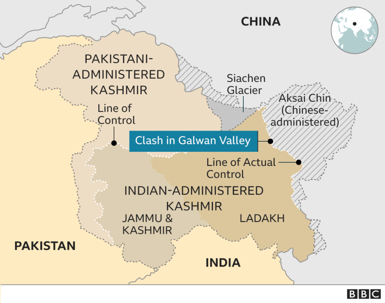
There are three regions where the current dispute is going on namely Pangong Lake, Galwan valley and hot springs near Konga.
1. Pangong Lake: Both Indian and Chinese army went for patrolling in this region which covered about 10km. Those conversations had turned into conflicts. From the past few years India started building infrastructure by building roads which made easy for India to transport the troops. China claims that their LAC lies in Finger 4 whereas Indian claimed LAC lies in Finger 8. The region between these fingers is termed as gray region. The first dispute began on 5th May 2020 and Chinese troops travelled to finger 5 and eventually reached finger 4 on 10th of May. Over 5000 soldiers are between Finger 4 and finger 8 which covered about 8km. Both the governments agreed not use guns and bullets. That is why we have seen savage kind of beating which includes the rocks, sticks, iron rods and fists. Intially Indian government claimed that three soldiers were killed and which rose to 20 in number the very next day. Indian claims that 43 Chinese soldiers were killed but there is no official announcement from the Chinese government.

2. Galwan valley: It is situated at the height of 14000 km above the sea level. They occupied 2-3kms of Indian territory which also gave them direct access to the Northern India. The main advantage to Chinese troops lies in the height itself. They can attact the Indian troops from above. We can’t say that Chinese intruded in the Indian land in Pangong river because there wasn’t a clear LAC. But here there is a clear border line which was agreed by both governments. Chinese crossed the border line.
3. Hot springs near Konga: It is the least affected area among the three. Chinese got no use of this area.
Rajnath Singh once admitted in an interview that Chinese soldiers crossed border. PIB made sure that it was a fake news. Few say that China is trying to evoke the nationalist sentiment amidst COVID19 crisis. Few say that Chinese is against the infrastructure that had been developed by India by building roads. The majority say that the government made Ladakh a union territory and this had made China to do so.
There are no natural resources in that area and still China try to conquer that frozen deserted land to show its power and strategic position in the world.

You must be logged in to post a comment.