

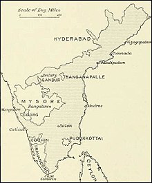
Pudukkottai was a kingdom and later a princely state in British India, which existed from 1680 until 1948.1913 map of the Madras Presidency showing location of Pudukkottai State.
The Kingdom of Pudukkottai was founded in about 1680 as a feudatory of Ramnad and grew with subsequent additions from Tanjore, Sivaganga and Ramnad. One of the staunch allies of the British East India Company in the Carnatic, Anglo-Mysore and Polygar wars, the kingdom was brought under the Company’s protection in 1800 as per the system of Subsidiary Alliance. The state was placed under the control of the Madras Presidency from 1800 until 1 October 1923, when the Madras States Agency was abolished, and until 1948 it was under the political control of the Government of India.
Pudukkottai State covered a total area of 1,178 square miles (3,050 km2) and had a population of 438,648 in 1941. It extended over the whole of the present-day Pudukkottai district of Tamil Nadu (with the exception of Aranthangi taluk which was then a part of Tanjore district). The town of Pudukkottai was its capital. The ruler of Pudukkottai was entitled to a 17-gun salute.
Geography.
The state of Pudukkottai extended from 10 degrees 7′ to 10 degrees 44’N latitudes and 78 degrees 25′ and 79 degrees 12′ E longitudes.and covered a total area of 1,178 square miles (3,050 km2). It extended for 52 miles (84 km) from east to west and 41 miles (66 km) from north to south.The state was bounded by Trichinopoly district to the west, Tanjore district to the east and south-east and Sivaganga estate of Madura district to the south.
The kingdom did not have fixed boundaries originally and was called “Tondaiman country” or “Tondaiman’s woods” until the end of 18th century. The kingdom started to have fixed boundaries since early 19th century. The easternmost point of Pudukkottai state was located 12 miles (19 km) from the sea. When the Pudukkottai district was formed in 1974 long after its incorporation into the Republic of India, the coastal Aranthangi taluk was detached from Tanjore district and merged with the new district.
For administrative purposes, the state was divided into three taluks: Alangudi, Kulathurand Thirumayam, each under the authority of a Tahsildar who was responsible for land revenue. There was also a few semi-autonomous zamindaris : Karambakadu, Nagaram, Palayavanam, Senthankudi and Seriyalur.
Demography..
As of 1931, the princely state of Pudukkottai had a total population of 400,694 with a population density of 340 people per square mile. Ponnamaravathi firka was the most densely populated with 498 people per square mile while Nirpalani was the most sparsely populated with 213 people per square mile.There were 435 towns and villages – 426 of them with a population less than 5,000 and nine – Pudukkottai, Ponnamaravathi, Varpet, Ramachandrapuram, Arimalam, Thirumayam, Alangudi, Kiranur and Pillamangalam-Alagapuri with population greater than 5,000.The male literacy rate was 21.62 percent and the female literacy rate, 1.87 percent.Between 1925 and 1929, the population of the state dropped by over 65 percent as more than 53,000 people left Pudukkottai for neighbouring districts due to widespread plague and famine.
Religion:
The kingdom was predominantly Hindu. However, there were significant Muslim and Christian populations. The affairs of Hindu temples was administered by a Devasthanams Department established in 1897.
According to the 1901 census, there were 353,723 Hindus who formed 93% of the state’s population. Muslims who numbered 12,268 formed 3.2% of the population while the Christians numbering 14,449 formed 3.8% of the population.In 1931, there were 367,348 Hindus (91.7 percent), 15,194 Muslims (3.8 percent) and 17,960 Christians (4.5 percent).
Languages :
The majority of the population spoke Tamil as their mother tongue. According to the 1931 census, Tamil was spoken by 378,741 people or 94.52 percent of the population as their mother tongue.Other languages spoken as mother-tongue included Telugu (12,250 speakers, 3.05%), Kanarese (5,118, 1.27%), Hindustani or Urdu (1,993, 0.49%), Saurashtri (1,172, 0.29%), Marathi (660, 0.16%), Malayalam (522, 0.13%), Hindi (187, 0.04%), Arabic (23, 0.005%), English (22, 0.005%), Danish (2, 0.0005%), Malay (1, 0.0003%), Sinhalese (1, 0.0003%), Konkani (1, 0.0003%) and Spanish (1, 0.0003%). The natives of Pudukkottai spoke Tamil which was also an official language of the state alongside English. Telugu-speakers were descendants of military chieftains who had migrated during the rule of the Vijayanagar Empire and the Madurai Nayak kingdom. Kanarese or Kannada was spoken largely by the Kuruba shepherds who had migrated from the Mysore kingdom.However, the Kurubars spoke a Kanarese dialect of their own with a heavy admixture of Tamil words.Hindusthani or Urdu was used by Pathani Muslims while Saurasthri and Marathi were spoken by the Saurashtra and Thanjavur Marathi migrants.
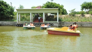
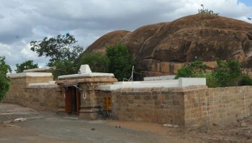
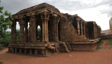
Tourist Places

A rock cut cave temple situated in the heart of the city built by Mahendravarma pallava is Known as Kokaraneeswarer…
A museum has been initiated by the state Government on 1910 AD with the antiquity of History, Geology, Zoology, Archaeology,Anthorapalogy…
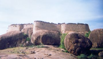
Olden days kings construct Fort and palaces, so as to protect the subjects from enemy country and a residential area…
It is located at a distance of 20 km from pudukkottai . The cave temples situated here are the testimony…
Avudaiyarkoil

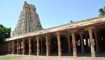
The temple dedicated Athmanatha samy situated in Avudayar koil at a distance of 60 km from pudukkottai, contain life-size sculptures….
Chithannavasal is a Prominent Tourist Centre of Pudukottai District. It is located on the Annavasal – Pudukottai Road at a…
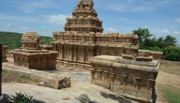
It is located at a distance of 17 km from Pudukkottai. Narthamalai is head Quarters for the Cheiftain of Mutharaiyar….
Pdukkottai District ,at Keezhayur panchayat a siva temple together with vishu temple have been situated with a distance of 33…
The name Kunnandar Koil is called as Thirukundrakudi in the inscriptions available in this Temple. It is located 40 km…

The name Kodumbaloor has been mentioned in the Tamil epic Silapathigaram. It is located at a distance of 35km from…

You must be logged in to post a comment.