History Blast from the Past : ISRO’s 20 Satellites in One Go through PSLV C34 Achievement >>>>>>>>>>>

SALUTE TO ISRO AND OUR GREAT SCIENTISTS

Sometimes rewind the moments related to country pride has quite satisfactory. In the post, I am recalling the ISRO’s historical moment of 2016 … 20 satellites in one go.

Isro scripted history on Wednesday by launching 20 satellites, including those from the US, Germany, Canada and Indonesia, from its Satish Dhawan Space Centre in Andhra Pradesh’s Sriharikota in one go.

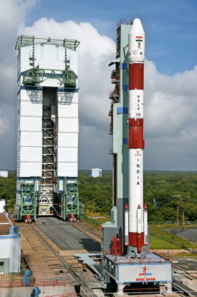
The Indian Space Research Organisation used its flagship rocket Polar Satellite Launch Vehicle (PSLV) C34 — standing 44.4 metre tall and weighing 320 tonne — for the lift-off that was lauded by Prime Minister Narendra Modiji.

Credit : Third Party Reference

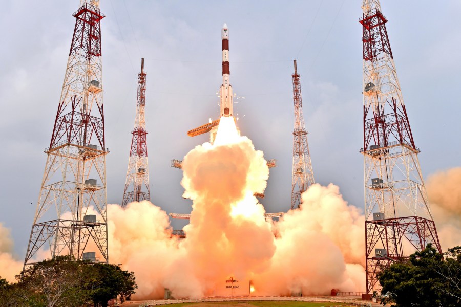
“Our space programme has time and again shown the transformative potential of science & technology in people’s lives,” he posted after the rocket tore into the morning skies at 9.26 am with a growl breaking free of the earth’s gravitational pull.

“Over the years we developed expertise & capability to help other nations in their space initiatives. This is the skill of our scientists.”

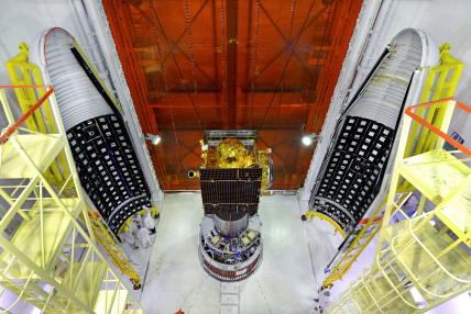
The 20 satellites weighed 1,288kg. The rocket’s main cargo is India’s 725.5kg Cartosat-2 series satellite for earth observation. This satellite is similar to the earlier Cartosat-2, 2A and 2B.

The other 19 satellites weighing around 560 kg are from the US, Canada, Germany and Indonesia as well as one satellite each from Chennai’s Sathyabama University and College of Engineering, Pune. The whole launch mission was over in around 26 minutes.

Isro chairperson AS Kiran Kumar congratulated his team on the successful launch ‘in record time’ and said “PSLV C-34 has done its job”.

“We have the current generation of earth observation satellite of Cartosat 2 series,” ISRO said, and added the space agency had done a “wonderful job”.

The images sent by Cartosat satellite will be useful for cartographic, urban, rural, coastal land use, water distribution and other applications.

The 110kg SkySat Gen2-1 belonging to Terra Bella, a Google company, is a small earth-imaging satellite capable of capturing sub-metre resolution imagery and high definition video, Isro said.

The Planet Labs Dove Satellites are also earth-imaging satellites. A total of 12 Dove satellites each weighing 4.7kg are carried in this mission inside three QuadPack dispensers, the space agency said.

Credit : Third Party Reference

The PSLV rocket also carriedf 85kg M3MSat from Canada. The technology-demonstration mission was jointly funded and managed by Defence Research and Development Canada and the Canadian Space Agency.

The other foreign satellites on board were: 120 kg LAPSN-A3 of Indonesia, the 130 kg BIROS, from German Aerospace Centre, and the 25.5 kg GHGSat-D, Canada.

The 1.5 kg Sathyabamasat from Sathyabama University will collect data on green house gases while the 1kg Swayam satellite from College of Engineering, Pune will provide point-to-point messaging services to the HAM radio community.

In 2008, the Isro had launched 10 satellites with the PSLV rocket. Till date India has launched 57 foreign satellites successfully.

Reference – https://divyanshspacetech.wordpress.com

But why can’t Globalized Navic as World Recognized GPS System : Super Exclusive >>>>>>>>

Why Navic :-

Navic is an independent Indian Satellite based positioning system for critical National applications. The main objective is to provide Reliable Position, Navigation and Timing services over India and its neighbourhood, to provide fairly good accuracy to the user. The IRNSS will provide basically two types of services

  1. Standard Positioning Service (SPS)
  2. Restricted Service (RS)

To date, ISRO has built a total of nine satellites in the IRNSS series; of which eight are currently in orbit Three of these satellites are in geostationary orbit (GEO) while the remaining in geosynchronous orbits (GSO) that maintain an inclination of 29° to the equatorial plane. The IRNSS constellation was named as “NavIC” (Navigation with Indian Constellation) by the Honourable Prime Minister, Mr. Narendra Modi and dedicated to the nation on the occasion of the successful launch of the IRNSS-1G satellite. The eight operational satellites in the IRNSS series, namely IRNSS-1A, 1B, 1C, 1D, 1E, 1F, 1G and 1I were launched on Jul 02, 2013; Apr 04, 2014; Oct 16, 2014; Mar 28, 2015; Jan 20, 2016; Mar 10, 2016, Apr 28, 2016; and Apr 12, 2018 respectively. The PSLV-39 / IRNSS-1H being unsuccessful; the satellite could not reach orbit.

Credit: Third Party Reference

Oh, Did I just ask to not address NAVIC (Navigation with Indian Constellation) as our own GPS (Global Positioning System). Have I lost my mind to go against the trend media has created? Am I actually serious about it? Well, let’s see why I am making such a preposterous appeal.

I have realised while talking to a lot of people on social media that they think GPS is a technology per say in generic terms which is completely incorrect. And the headlines all over media are reflecting as such. So first let’s talk about different satellite based navigation systems.

WHAT IS GPS :-

GPS (Global Positioning System) is a global satellite-based navigation system made up of a network of 24 satellites placed into orbit by the U.S. Department of Defense (DoD). It is a U.S.-owned utility that provides users with positioning, navigation, and timing (PNT) services. This system consists of three segments: the space segment, the control segment, and the user segment. GPS is operated and maintained by the U.S. Air Force. It is currently the world’s most utilized satellite navigation system.

ABOUT GNSS :-

The generic name of what we assume to be GPS is GNSS (Global Navigation Satellite System). Currently there are two operational GNSS:
1) Global Positioning System (GPS) is owned by the United States.
2) GLONASS is owned by Russia.

The third GNSS- GALILEO of European Union isn’t completely operational yet, 12 of 30 satellites in orbit. The forth BeiDou (Chinese Navigation system) is a limited test system, its full-scale global navigation system or GNSS also known as COMPASS or BeiDou-2 is currently under construction, it has about 20 satellites in orbit at present.

THEN WHAT’S THE ISSUE?

See, by now we have developed GPS isn’t a generic term, it’s just most popular and we human race runs after something that’s always more popular and it’s exactly what needs to be changed if we want to create our own identity in this world, if we want to stand with pride, if we want other nations to respect and recognise us then we need to be own people and not some ripped off identity of other nation and that’s what NAVIC deserve.

Credit: Third Party Reference

NAVIC was developed after so much of continuous handwork of ISRO scientists, thorough research and loads of money. It isn’t just another satellite based navigation system, it made us the fifth elite nation in this world to have our own navigation satellite system and it is a big deal. I am forever grateful to GPS for extending its services to us but we (India) developed and deployed NAVIC because many of the GPS services weren’t available to defence forces specially and we needed that thus came NAVIC.

NAVIC made us a proud nation, it showed the world the powerful force India is, it showed that we were Inventers/developers, we are and we always will be. We have some of the best brains in the world that is what NAVIC represents. It’s our pride and giving it a second hand name just dishearten me and it should dishearten you as well.

China has its own search engine Baidu and they do not call it ‘Chinese Google’. We do not call Flipkart as ‘India’s Amazon’ or Ola as ‘India’s Uber’ or every Smartphone an iPhone. Even you wouldn’t like to be called by other’s names!

What we say today, what we trend today will be remembered tomorrow and I do not want NAVIC to be known as ‘Indian GPS’.

If you agree with me then kindly share this post, raise your voice, talk about it, and aware more people about it. All I want is NAVIC to be known as NAVIC to the entire world and I need your help in doing so.

Reference- divyanshspacetech.wordpress.com and isro.gov.in