Karst Topography

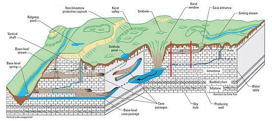
Karst is a type of landscape where the dissolving of the bedrock has created sinkholes, sinking streams, caves, springs, and other characteristic features. Karst is associated with soluble rock types such as limestone, marble, and gypsum. In general, a typical karst landscape forms when much of the water falling on the surface interacts with and enters the subsurface through cracks, fractures, and holes that have been dissolved into the bedrock. After traveling underground, sometimes for long distances, this water is then discharged from springs, many of which are cave entrances.

Chemical Reaction:-

Limestone is a type of carbonate rock — that is, a rock made up primarily of a carbonate mineral which, in the case of limestone, is usually calcite or aragonite. These are both forms of calcium carbonate (CaCO3). Over time, limestone may be dissolved by carbonic acid (i.e., carbon dioxide dissolved in water). Carbonic acid is formed when rain picks up CO2 as it falls through the atmosphere. Once it hits the ground, it may pick up more CO2 in the soil, turning into a weak carbonic acid solution. When this solution seeps into limestone bedrock via cracks and fissures, larger openings are created. Over the course of thousands of years, this erosive process creates underground drainage systems and caves.

Mammoth Cave,USA is the longest Cave system in the world.

Xiaozhai Tiankeng,China Largest Sinkhole.

Other examples,Yutacan peninsula,Mexico

Cockpit Country,Jamaica etc.

In India karst topography is present in the Vindhya region (mainly southwestern Bihar), the Himalayas (parts of Jammu & Kashmir, Robert Cave, Sahasradhara, the eastern Himalayas, areas near Dehradun), Pachmarhi in Madhya Pradesh, the surrounding coast near Vishakhapatnam, and Bastar in Chhattisgarh.

Landforms :-

Earthquakes

Earthquake, any sudden shaking of the ground caused by the passage of seismic waves through Earths’s rocks. Seismic waves are produce when some form of energy stored in Earth’s crust is suddenly released, usually when masses of rock straining against one another suddenly fracture and “slip.” Earthquakes occur most often along geologic faults, narrow zones where rock masses move in relation to one another

  • tectonic earthquake is one that occurs when the earth’s crust breaks due to geological forces on rocks and adjoining plates that cause physical and chemical changes.
  • volcanic earthquake is any earthquake that results from tectonic forces which occur in conjunction with volcanic activity.
  • collapse earthquake are small earthquakes in underground caverns and mines that are caused by seismic waves produced from the explosion of rock on the surface.
  • An explosion earthquake is an earthquake that is the result of the detonation of a nuclear and/or chemical device.

Seismic waves is of three types-primary waves,secondary waves and surface wave.

Of the body waves, the primary waves has the higher speed of propagation and so reaches a seismic recording station faster than the secondary, or S, wave. P waves, also called compressional or longitudinal waves, give the transmitting medium whether liquid, solid, or gas a back-and-forth motion in the direction of the path of propagation, thus stretching or compressing the medium as the wave passes any one point in a manner similar to that of sound waves in air.

P waves can travel in all three medius.S waves can only travel in solid medium.

Two common surface waves are Love waves (L wave) and Rayleigh waves (R wave). The L-waves are the slowest among the earthquake waves and are recorded last on the seismograph.
Of the four seismic waves, most of the shaking and damage from an earthquake is due to the Rayleigh
wave (R-wave).

Earthquakes can occur due to human activity or natural reason like volcano,tsunami etc.

“Zealandia- 8th Continent Soon ?”

Science and technology has helped humans in discovery of a number of things hidden deep inside sea, land, and even outer space. The invention of internet had gave birth to globalization  and people could travelling around the world, talk to people from on end to other end, get information about any topic they want, just with a single click and many more. While most of the earth secrest remain hidden, there have been some human advancement to discover some of them and thus gain more knowledge.There have been various theories reflecting the facts of drowned cities and islands due increase in water level or tsunamis or any other factotre like tectonic shift. Scientists have really been fascinated towards these facts and thus they have been finding some of those and thus get an idea about how early life was. The search of these led them to find the 8th continent which was expected to be lost crores of years ago. “Zealandia” is the name given to this continent and soon we can see it as an accepted continent around the world. 

Zealandia is present between Australia and New Caledonia in the South Pacific Ocean. The interesting fact to know is that about 94% of the land is submerged under water. According to the American Geological Society, Zealandia has an area of 50 lakh square km, which equals to about 66% of total Australian land. Zealandia was expected to be a part of Australia, but due to tectonic shift, it got away from it and drowned in water. So It’s fascinating to know about such a place and scientists went on a drilling experiment and collected some samples of rocks of Zealandia.The results were really good enough as they were rich in silica, granite and limestone. But how could be find a continental, suddenly. The first theory of Zealandia was given in 1995 and after then in 2017 , it was accepted to be land which could be named as a continent by most of the scientists but still not official. So with the help of the latest technologies , we were able to reach this place  and find the lost continent probably. 

Zealandia can be provided the designation if a continents, since it fulfills some of requirements required for it to be a continent .These include.:

  1. Continent needs to have elevation above the ocean floor , surrounding it. Which surely is as we see most of the land above the ocean floor through the images captured. 
  2. The crust of the continent must have igneous, sedimentary and metamorphic rocks, which certainly are present in it as per the experiments done by the experts. 
  3. The crust must be thicker and less dense than the oceanic crust. We see the thickness of Zealandia is thicker than the ocean floor we see, which makes it visible and also less than the oceanic crust. 
  4. It must be spread across a wider area. Interesting fact about Zealandia is that it’s size lie between the biggest island and smallest continent, so it might be a confusion to name it as an island or a continent. 

The benefits of such a piece of land which was under land for so many years could be enormous. It Would be rich in resources, new metals and stones and also would help us to understand what earth would have been so many years ago and most if its parts are untouched and pure. This could surely lead us to open up new possibilities and resources. 

But the big question still remains is will Zealandia get a position of a new continent. It’s still a question  most scientists have been conflicting up for. The main issue is that we do not actually know the pure definition of what a continent truly is, and how we separate it from other big islands. Maybe in the future we would be able to notice a wide change in our geography with 8 continents, new possibilities of research and development and a lot more understanding about our earth and it’s hidden secrets.