
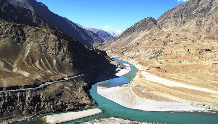
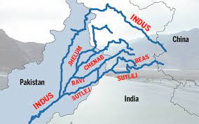
The river Indus as said about the Ganga is a transboundary river that flows Ladakh and Kashmir northwards, passes leftwards towards Nanga Parbat Massif, and Pakistan southwards and ends its journey in the Arabian sea by Karachi. The Indus is termed to be one among the world’s largest rivers in average annual flow, with an estimate of 243 cubic km, which is twice and thrice of the river Nile and the Tigris with the Euphrates combined respectively. The Indus originates from the Tibetan plateau near Lake Manasarovar and enters India in Ladakh. It cuts through the Himalayas in a deep gorge near Nanga Parbat to enter Pakistan. It has five main tributaries – the Sutlej, the Beas, the Ravi, the Chenab and the Jhelum. These rivers give Punjab its name, for the word ‘Punjab’ means ‘five rivers’. This Himalayan river is both snow-fed and rainfed, and therefore flow continuously throughout the year. The river Indus, also known as the Sindhu river, flows for 2897 km, mostly through Pakistan. Since the river moves slowly across the plain, it deposits accumulated silt on its bed. The river bed is thus higher than the sandy plain. When the river is in flood, this results in much destruction. The Indus finally branches into distributaries that join the sea at Karachi. The very river is also famous for the Indus river dolphin, a freshwater dolphin, and one of the world’s rarest mammals. It is, also the second most endangered freshwater river dolphin.
Regions through which the Indus flows
The Indus rises in southern Tibet at a height of about 5500 metres. It flows through a high plateau, then the ground falls away, and the river drops rapidly, and gathers momentum. It rushes northwest and collects the waters from innumerable glacier-fed streams. It flows between the greatest mountain ranges, the Karakoram and the Himalayas. generally, the river becomes slower and has a wider channel as it approaches its delta on the Arabian sea. Agriculture in Pakistan wouldn’t be even possible without this river. In addition, it supplies essential ingredients for human life for many urban areas. These include the Pakistani cities of Islamabad, Lahore, Peshawar and Karachi. Therefore the Sindhu is Pakistan’s longest river with a total length of 3180 km.
The Chenab
The Chenab rises in the upper Himalayas, in the district of Himachal Pradesh in India. Its waters begin from snowmelt from the Bara Lacha Pass. During the Vedic period, it was known as Chandra Bhaga, and it begins at the confluence of two rivers, the Chandra and the Bhaga in Himachal Pradesh. It flows through the Jammu, into the plains of Pakistan. It is first joined by the Jhelum, and then by the Ravi rivers. Later, it meets Sutlej, which has earlier been joined by the Beas. Altogether, these form the so-called ‘five rivers of Punjab’. After, 960 km, it flows into the Indus. The river is dear to the people of Punjab. Moreover, it forms an important part of the land’s history and culture.
Fact: The world’s highest railway bridge – the Chenab bridge – spans the Chenab. It crosses the river in Jammu and Kashmir.
The Jhelum
The Jhelum is the largest, and most western Punjab’s five rivers. It is an ancient river that has been mentioned both by the ancient Greeks as well as ancient Egyptians. It rises from a deep spring, the Verinag Spring in the southeastern part of the valley of Kashmir in India. the river wanders northwards through the valley of Kashmir to the Wular Lake. After emerging from the lake, it continues winding its way through a deep gorge into Punjab. It widens out into an alluvial plain and then goes south to join the Chenab at Trimmu after 813 km. its flow is controlled by snowmelt and the monsoon. In its lower course, the river is famous for its hydroelectric power generation. The Mangla dam and the reservoir on the Jhelum irrigate around 3 million acres of land.
The Ravi
The Ravi, one of the five rivers that create Punjab, crosses national boundaries. It rises in the majestic Himalayas in the state of Himachal Pradesh in India. It crosses Jammu and Kashmir and then flows into Pakistan. After 725 km, it empties itself into the Chenab. It is fed by glacier melt and is the smallest of all rivers of Punjab. In Vedic times, the Ravi was known as Iravati or Airavati river. It is a trans-border river of India and Pakistan. After partition, the river waters were divided between India and Pakistan.
Fact: It irrigates a large area in Punjab through a canal. This canal is known as the upper bari doab canal.
The Beas
The river Beas, one of the five rivers of Punjab, is famous in world history. It is one of the rivers that created problem’s in alexander the great’s conquest of India. His troops mutinied here in 326 BC, refusing to go any further, as they had been away from home for eight years. The Beas rises from the Rohtang Pass in the western Himalayas of Himachal Pradesh and flows south through the Kulu valley. It then enters Punjab and flows in a southerly direction. Thereafter, it finally meets the Sutlej after flowing for 470 km. the chief tributaries of the Beas are bain, Banganga, Luni and Uhal. The river was known in ancient India as the Vipasha, while the ancient Greeks called it the Hyphasis. In the 20th century, it was developed for irrigation and hydroelectric power generation.
The Sutlej
The Sutlej, the longest Punjab’s five rivers, has its source in the Rakshastal lake in Tibet. Sometimes called the red river, it is the easternmost of the Indus river’s tributaries. Further next, it rushes through the Himalayan gorges, and crosses Himachal Pradesh, before entering Punjab. It then joins the Chenab and they empty into the Indus. There are many irrigation projects along its 1400 km long course. They include the Bhakra- Nangal project, and the Sirhind canal. In addition, there is also the Sutlej valley project which benefits both India and Pakistan.
Fact: In the villages of the Sutlej valley you will find descendants of the yak traders of the olden times. These traders were known as Zhang Zhung.
The Indus: the cradle of civilization
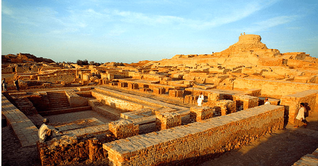
One of the greatest civilizations of ancient times flourished on the banks of the river Indus. Around 3300 BC, there were two great cities in the Indus valley, Harappa and Mohenjo Daro. They were very planned and had houses built with bricks, and even a proper drainage system. The town planning, water supply, sewage and drainage system were of very high quality – there were bathhouses and granaries in plenty, too. These cities prove to the world that the most sophisticated urban civilization of its time flourished in India, more than 5000 years ago! The wonders of engineering and architecture, the richness of the culture, and the quality of the life enjoyed by the people all prove that the valley stood to be the cradle of civilization.
The river basin covers an area of around one million square kilometres and extends to four countries. They are China, India, Afghanistan and Pakistan. Snow and glacier meltwater is the main source of water for this river system, as rainfall is low in the region. It ends in a delta, which includes numerous mangroves. The Indus basin stretches to the Karakoram and Haramosh ranges in the north, the Arabian Sea in the south, the Sulaiman and Kirthar ranges in the west, the Himalayas in the east. In India, the basin spreads over the states of Jammu and Kashmir, Himachal Pradesh, Punjab Rajasthan, Haryana and the union territory of Chandigarh.
Indus Water Treaty
India and Pakistan are two of the four countries through which the Indus river flows. The waters of the same and its tributaries support life in vast areas in these two countries. The Indus river system consists of three western tributaries of the Indus and three eastern rivers. The treaty was a result of Pakistani fears that since the sources of the rivers of the Indus basin were in India, India would have total control of the water. So, the world bank drew up a water-sharing treaty called the Indus water treaty. According to this treaty, the Ravi, the Beas and the Sutlej, which constitute the eastern rivers, are allocated for exclusive use by India, before they enter Pakistan. Similarly, Pakistan has exclusive use of the western rivers the Jhelum, the Chenab, and the Indus. The treaty was signed in Karachi on September 19th, 1960.
Major cities in the Indus basin
Industries in the Indus river basin are mainly based on agriculture and allied products. These include the textile, woollen, sugar, oil and paper Industries, as well as Industries manufacturing agricultural equipment. Other Industries in the region are cement, automobiles, machine and machine parts. These Industries have led to the growth of many towns and cities in the river basin. Important urban centres and towns in the basin are Chandigarh, Srinagar, Shimla, Ambala, Bikaner, Bathinda and Patiala. Chandigarh serves as the capital of Punjab and Haryana while Srinagar is the capital of Jammu and Kashmir. Shimla, a beautiful city on the forested hillside of the Himalayas, is the capital of Himachal Pradesh.
Problems faced by Indus rivers
Rapid population growth
As the Indus is one of the longest rivers in Asia, and many civilizations shaped near it, the rapid population growth has a serious hand on the pollution caused. As the number of people around it increases so does the manipulation and excessive use of river water. Thus it could be concluded that the human actions that affect the river pollution counter affect them.
Increased cultivation rate
As the population increases, so does the need for food. Thus for achieving this the cultivations as a whole should be raised to a certain level covering the need. Added to this the Indus basin highly supports cropping. The exploitation caused by chemical fertilizers and pesticides used had serious effects on the river. The
Issues related to reservoir
The inefficiency of the reservoir had been in great discussions among authorities over the years. the increased freshwater need has come to a greater problem. Added to the low capacity of reservoirs, is the issue of inefficient management of the same.
Sewage management
The untreated sewage disposal to the rivers had adversely affected their condition for too long. The urban sewage added to the industrial waste is strengthening the damage caused. Proper treatment of the sewage is the only possible way to counterattack this issue.
Excessive industrialization
The Indus is a cradle of civilization, many industries grew near it, making it a great industrial site from time immemorial. So is the industrial waste disposal to the water bodies. The extensive water manipulation on the industrial need and discharge of the harmful by-products to the rivers marks the need for sustainability over the industrial sector. It is said that it is one of the top rivers that end up polluting the oceans.
Regional climate change
The fast-paced climatic changes such as the overheated summers causing glacier melts in a higher level are the representations of unstable weather conditions. This then leads to a decrease in river water flow. Well, it isn’t a new fact that global warming the main enemy. When fossil fuels are burned which then increases the greenhouse effect leading towards glacier melts. The minute changes in water flow can even cause not so smaller but undesirable changes in crop production and the organisms.

You must be logged in to post a comment.