Different Landforms that exists in the World

The earth is a fascinating place with all kinds of variation and geographical interest. All over the world, wild and wondrous things have happened. These occurrences have created a series of landforms throughout Earth’s lifespan that make each many areas unique.

As defined by National Geographic, a landform is a “feature on the Earth’s surface that is part of the terrain.” The terrain of the land includes all of its topographic features. Whether a formation sticks out of the ground or sinks into it, it has topographic significance. 

Endogenic forces and exogenic forces can create a lot of landforms. Mountains, hills, plateaus, and plains are the four major types of landforms. Minor landforms include buttes, canyons, valleys, and basins.

There are four major types of landforms. There are four that are accepted throughout the scientific community. These include mountains, plateaus, hills, and plains. Everything else can fall into these broad and general categories.

There are hundreds of minor landform typologies. Some of them are well known, like valleys. Others you have probably never heard of since they only belong to particular geographic regions.
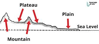
Mountains

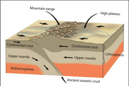
  • A mountain is a large landform that rises above the surrounding land in a limited area, usually in the form of a peak. A mountain is generally steeper than a hill.
  • Mountains are formed through tectonic forces or volcanism. These forces can locally raise the surface of the earth.
  • Mountains erode slowly through the action of rivers, weather conditions, and glaciers. A few mountains are isolated summits, but most occur in huge mountain ranges.
  • Nearly 27% of the world’s land surface is covered by mountains.
  • It is from the mountains that up to 80% of the planet’s fresh surface water come from.
  • According to the UN’s Food and Agriculture Organization (FAO), about 12% of the world’s population lives in the mountains, but over 50% are directly or indirectly dependent on mountain resources.

The mountains, on the basis of their mode of formation, can be classified as:

  1. Fold Mountains
  2. Block Mountains
  3. Volcanic Mountains/ Accumulated Mountains
  4. Residual Mountains/ Relict Mountains

Examples of mountains:- Himalayas, Andes, Rocky Mountains, Alps, Appalachian Mountains, Ural Mountains, Karakoram

Plateaus

  • A plateau is a flat-topped table land.
  • Plateaus occur in every continent and take up a third of the Earths land.
  • They are one of the four major landforms, along with mountains, plains, and hills.
  • Plateaus, like mountains may be young or old. The Deccan plateau in India is one of the oldest plateaus.
  • Valleys form when river water cuts through the plateau. The Columbia Plateau, between the Cascade and Rocky mountains in the northwestern United States, is cut through by the Columbia River.
  • Sometimes, a plateau is so eroded that it is broken up into smaller raised sections called Many outlier plateaus are composed of very old, dense rock formations. Iron ore and coal often are found in plateau outliers.
  • Plateaus are very useful because they are rich in mineral deposits. As a result, many of the mining areas in the world are located in the plateau areas.

The plateaus can be classified as:

  1. Intermontane Plateaus
  2. Piedmont plateaus
  3. Continental plateaus
  4. Volcanic plateaus
  5. Dissected plateaus

Plains

  • Plain, any relatively level area of the Earth’s surface exhibiting gentle slopes and small local relief. Plains vary widely in size.
  • The smallest occupy only a few hectares, whereas the largest cover hundreds of thousands of square kilometers—as, for example, the Great Plains of North America and the expanse of gently undulating land that sweeps from the Pyrenees Range on the French–Spanish border across northern Europe and Asia almost halfway around the world nearly to the Bering Sea.
  • Occupying slightly more than one-third of the terrestrial surface, plains are found on all continents except Antarctica.
  • Most of the plain have been formed by deposition of sediments brought down by rivers. Besides rivers, some plains have also been formed by the action of the wind, moving ice and tectonic activities
  • They occur north of the Arctic circle, in the tropics, and in the middle latitudes. Corresponding to their broad geographical distribution, the plains of the world show considerable variation in vegetation.
  • Some are tree-covered and others are grassy. Still, others support scrub brush and bunch grass, while a few, which are nearly waterless deserts, have only the most sparse and scanty plant life.

More common examples of plains include:

  1. Great Plains (US) – 1,100,000 square miles
  2. Canterbury Plains (New Zealand) – 195 square miles
  3. Australian Plains – 2,966,200 square miles
  4. Serengeti Plains – 11,583 square miles
  5. European Plain – 2,000,000 square miles
  6. West Siberian Plain (Russia) – 1,200,000 square miles
  7. Indus Valley Plain (Pakistan) – 200,000 square miles

Hills

  • Hills are like tiny mountains. They share many of their characteristics with mountains.
  • For example, hills have to have a higher elevation than the land around them.
  • Hills are smaller than mountains and are also not as steep. Although the heights of some hills might be close to some small mountains, their gently sloping nature prevents them from being a mountain.

Some of the more famous hills in the world include:

  1. Chocolate Hills (Philippines)
  2. Ananthagiri Hills (India)
  3. Tuscany Hills (Italy)
  4. Glastonbury Tor (England)

What is MSP?

India is an agriculture dominated country. More than 50% of Indian workforce is employed by the agriculture. Farmers strive hard to produce high yield and quality products but their income is less than expenses. Market price is determined by supply and income demand. When there is large supply of crops but less demand , there is sharp fall in farm prices affecting farmers drastically. There is always price fluctuations in agricultural products while farmers get a decent return when there is shortage of supply,the same products fetch them poor price during bumper harvest season.
The government of India has introduced MSP (Minimum Support Price ) to protect producers against excessive fall in farm prices leading heavy loss suffered by the farmers.MSP is the minimum price a farmer must be paid for their agricultural produce as guaranteed by the government of India. If the market price falls below MSP, the government procures that crop from the farmers at MSP. MSP is announced for  22 major crops along with a Fair Remunerative Prices (FRP) for sugarcane. MSP is recommended by Commission for Agricultural Costs and Prices (CACP) but the final decision is taken by the Cabinet Committee on Economic Affairs(CCEA) of union government.

MSP ensures profit of atleast 50% over the cost of production for the farmers.It includes cost of production, domestic and international prices, demand-supply conditions, inter-crop price parity and the terms of trade between agricultural and non-agricultural sectors.
Farmers are free to sell their products to any non-governmental parties, if they get favorable terms to sell their products or better than MSP. The government mainly buys rice and wheat at guaranteed price.

Benefits of MSP:
• It acts as a surety to farmers so that their crops get the fair amount for their produce and helps them sustain their losses and does not affect them drastically
• It helps to keep a floor price which does not let the prices fall below a certain point.
• The government can use these crops to be sold at government fair price shops at a price lower than market rate that will also help the government recover some amount and reduce the losses of the government.
• It safeguard the interest of the consumer by ensuring supplies at a reasonable price.
• Government manages food scarcity by distribution of stored grains at affordable prices.

Drawback of MSP :
It doesn’t increase in proportion to the increase in cost of production.
• There are a lot of farmers who don’t have adequate information about MSP and are exploited by middlemen.
• There are several regions in the country where farmers can’t access to the benefits through MSP.
• Open market workings , which works on supply and demand relations is detrimental for farmers , is disrupted by government intervention.
• Maintenance cost of procuring grains is raised by MSP which affects the investment in agri-infrastructure.

The Anthropocene

The Earth is divided into geological time scales, each denoting events that occurred in Earth’s geological history, by scientists. The scale begins with the formation of the Earth about 4.5 billion years ago, known as “Hadean”. The current geological epoch is known as the “Holocene”, which began approximately 11,700 years ago. The Holocene epoch is characterized by the rapid proliferation and spread of the human species on Earth. The “Anthropocene” is a proposed epoch that follows the Holocene and marks the period when human activity has started to have a significant impact on the planet’s ecosystem. The term “Anthropocene” was first proposed by the Dutch chemist Paul J. Crutzen and American biologist Eugene F. Stoermer (Crutzen & Stoermer 2000) to denote the current period in Earth’s geological history wherein, instead of the environment shaping humans it is the humans who are shaping and drastically altering the environment.

The Anthropocene, according to Steffen et al. is divided into three periods (616). It begins with the industrial revolution, wherein man first harnessed the energy of fossil fuels, coal, and oil and gas. The extensive use of the newfound wealth of energy in the form of fossil fuels stamped a significant imprint on Earth’s environment, evident in the increase in deforestation and rise in the concentration of methane, carbon dioxide, and nitrous oxide in Earth’s atmosphere (616). The second period, from 1945-to 2015, is known as the “great acceleration”. This period is characterized by an exponential increase in the impact of humans on the Earth system. An increase in the population of humans and an increase in industrialization resulted in a substantial increase in the concentration of greenhouse gases in Earth’s atmosphere (618). The third period, from 2015 onwards, is known as “stewards of Earth’s system”. This period is marked by the recognition of Anthropogenic influences on the Earth system and the subsequent filtration of this growing awareness on decision-making processes (618).

The major problem represented by the Anthropocene is the radical shifts in Earth’s temperature and biodiversity. These shift include global warming, extinction of species, habitat loss, and changes in the chemical composition of oceans and soils. Other probelms inlclude sustenance of human vices like greed, indifference, and intemperance.

There are, according to Steffen et al., three philosophical approaches to dealing with these problems. Firstly, is the business-as-usual philosophy (619), which employs a laissez-faire mindset when dealing with the changing global environment. The second is mitigation which is “based on the recognition that the threat of further global change is serious enough that it must be dealt with proactively” (619). And the third option is geoengineering (619), which attempts to solve the problem of climate change with technology.

Works cited

Crutzen, Paul J. and Eugene F. Stoermer 2000. The “Anthropocene.” Global Change Newsletter (41): 17–18.

Steffen, Will, et al. “The Anthropocene: Conceptual and Historical Perspectives.” Philosophical Transactions of the Royal Society A: Mathematical, Physical and Engineering Sciences, vol. 369, no. 1938, 2011, 842–67. Crossref, https://doi.org/10.1098/rsta.2010.0327.

Steffen, Will, Paul J. Crutzen, et al. “The Anthropocene: Are Humans Now Overwhelming the Great Forces of Nature.” AMBIO: A Journal of the Human Environment, vol. 36, no. 8, 2007, 614–21. Crossref. https://doi.org/10.1579/0044-7447(2007)36[614:taahno]2.0.co;2

Significance of “Ganga Dussehra”

This year ganga dussehra will be celebrated on 9 June Thursday till 10 june Friday 2022.On this day devotees of godness ganga worship her holy incarnation and presence on earth. It is believed that a holy dip in ganga is equal to hundred Mahayagnas. Traditionally, this festival is also known as Gangavataran or Ganga Dashara. According to the books of Hindu mythology, it is believed that on this day Goddess Ganga descended on the planet earth. As per ancient beliefs, King Bhagirath from the Sagara Dynasty once worshiped Lord Brahma for purifying the souls of his ancestors and relive them of the curse, so that they can attain salvation. Lord Brahma asked the king to worship Lord Shiva as it was difficult for Lord Brahma to bring Goddess Ganga to earth for her rage and only Lord Shiva had the power to control it.Pleased by his prayers and dedication, Lord Shiva gave him a vardan (blessing) and he asked Lord Shiva to control the rage of Goddes Open App olding her in his Jata (hair) to save the earth from destruction. This festival is usually celebrated during Summers and it is believed that after worshiping and taking a holy dip in Ganga, donating food, fruits, vegetables, rice, flour, ghee, money, water containers etc can bring prosperity and happiness in life. It is believed that a person who stands in the holy Ganga, worships her and recites Ganga Strotam on this day finds a place in Baikunth after death. If you are unable to reach the river ghat, mixing a few drops of holy Gangajal gives the same virtue of Like any other occasion in Hindu mythology, the Ganga Dussehra festival has its own significance, values, and importance. The following blog will lead you through the journey of this auspicious event. Why ganga dussehra is celebrated? The legend has it that the king named Sagara had 60,000 sons searching for a lost horse for the Ashwamedha Yagya tied near the Ashram of Sage Kapil by God Indra. The 60,000 sons said to possess created tons of commotion that disturbed the meditating Sage Kapila and anger when the sage opened his eyes. So he burned them to ashes. He told them the touch of the water Ganga would only give them the Moksha. As per the legend, one among the descendants of King Sagara named Bhagiratha performed austerity to gratify Brahma and send Ganga on earth.Goddess Ganga then descended to earth in seven streams and washed down all the ashes of Bhagiratha ancestors, and thus, Ganga Dusshera is widely known because of the day when the river . King Sagara of the Suryavansha dynasty had decided to perform the Ashwamedha Yajna (horse sacrifice) to prove his supremacy. However, Lord Indra, considering the sacrifice results, stole the horse enlisted to perform the yajna and delivered it to the ashram of Kapila, a sage immersed in meditation.King Sagara’s 60,000 sons began to seek out the horse. Kapila snapped out of his meditation before they might do him any harm. As a consequence of their disrespect towards a venerated sage, the sons were burnt to ashes.While returning the horse to King Sagara’s grandson, Kapila revealed that the sons might be redeemed if the Ganga descended on earth and purified their souls with its water.King Sagara’s great-grandson, Bhagiratha, wished to free his ancestors from the curse. So, after much penance, he pleased the Ganges to descend from heaven, but not without a caveat: her currents would destroy the world.Anxious to deliver his ancestors, Bhagiratha prayed to Lord Shiva, who, impressed by his determination, agreed to interrupt the Ganga’s fall .

Approach for TOD Implementation


1) Influence Zone 

The area in the immediate vicinity of the transit station, i.e. within a walking distance, having high density compact development with mixed land use to support all basic needs of the residents is called the influence zone of a transit station/corridor. Influence zone is either established at a transit stations or along the transit corridors. It is generally up to a radius of nearly 500-800m of the transit station. Where the distance between the transit stations is less than 1 km and there is overlap in the influence area, it can be identified as a delineated zone (around 500m) on either side of the transit corridor within 10 – 12 minutes walking distance. 

2) High Density Compact Development 

TOD promotes densification in the influence area by providing higher Floor Area Ratio (FAR)/ Floor Space Index (FSI) and higher population and job density as compared to the area around and beyond the influence areas. To ensure sustainable development, the minimum FAR should be 300 – 500%, and can be higher, depending on the city size. This will promote higher concentration of people within the walking distances of transit station, thereby increasing the ridership of the public transport and resulting in increased fare revenue, pollution and congestion reduction.

3) Mixed Use Development 

Mixed land use should be stipulated for development/redevelopment in the TOD zone as it would reduce the need for travel by providing most of the activities such as shopping, entertainment and public amenities such as schools, parks, playgrounds, hospitals etc. within the walking distance of the residents. It would also improve the accessibility of the transit facilities and at the same time link origins and destinations, i.e. residences with work places or activity nodes. This would ensure better utilization of transit fleet by distributing loads in both directions, rather than creating unidirectional peak hour flows. 

4) Mandatory and Inclusive Housing 

The cities should fix a minimum percentage (30% or higher) of allowed FAR for affordable housing (for example up to 60 sq.mt. area) in all development/redevelopment in the influence zones. Housing in the influence zone should have a mix of all economic groups/sections. The development control regulation should stipulate housing for Economically Weaker Sections (EWS) in the influence area to give an opportunity to the people who depend on public transport for daily commuting to live in walkable neighborhoods. 

5) Multimodal Integration 

The influence area should have high quality integrated multimodal transport system for the optimum use of the facilities by the residents/users. The system should have seamless physical connectivity, information integration and fare integration across modes so that the first and last mile connectivity does not become a bottleneck in the use of public transit systems by the citizens. The transit system, including its stations, should be designed to provide high quality services that assure user satisfaction in terms of safety and comfort. The citizens should have barrier free access to all the required amenities in the transit system as well as around the transit centers. 

6) Focus on Pedestrians, Cyclists and NMT Users 

The streets should be designed for users of all age groups and for all types of commuters including pedestrians, bicyclists, motorists and transit riders. They should be safe and accessible by all. The influence zone should have development in smaller blocks with a finer street network having provision for pedestrians, bicyclists and NMT (Non-Motorised Transport) users. This will create a grid of small, traversable blocks which has sidewalks and amenities like lighting and information signage etc. and ensure accessibility of the transit stations by pedestrians and cyclist. 

7) Street Oriented Buildings and Vibrant Public Spaces 

Retail and other ‘active uses’ should be supported on the ground floor along the main streets, key intersections, stations and parking garages to ensure high quality pedestrian environments. To promote natural surveillance of public spaces, all boundary walls and setbacks should be removed and buildings should be permitted up to the edge of the street. Also, the orientation of the buildings should be such so as to face the pedestrian facilities. The streets should have a natural surveillance system by providing mixed use active frontage, vending zones and avoiding opaque wall, which would ensure a safe environment for pedestrians, especially women, children and elderly. 

8) Managed Parking 

To discourage the use of private vehicles and to manage parking in TOD, it is essential that the supply of the parking is reduced and made expensive within the influence zone. On street parking should be prohibited within 100 m of the transit station, except for freight delivery and pickup or drop off of the differently abled. The use of parking spaces within the influence zone can be maximized by sharing of spaces between uses that have demand during different times of the day. For example parking requirements for office/work can be shared with the parking spaces for residences as their hours for demands do not coincide with each other.

The Deep under world- MARIANA TRENCH

The infamous Mariana Trench sits like a crescent shaped dent in the floor of the Pacific. A 2,550kms long, 69km wide fracture that plummets down into a pure black/ dark void.

At the bottom it hosts the deepest known location on the Earth, the Challenger Deep- 11,033meters or 36,200feet beneath the waves. The trench itself is, but one part of the global network of deep scars that cut across the ocean floor. Features that formed from a process called “subduction”.

In the case of the Mariana Trench, the western edge of the Pacific plate was thrust beneath the smaller Mariana plate to the west, creating the deep fracture. Molten material then rose through volcanoes near the trench, building the nearby Mariana islands.

At its deepest point, The Mariana trench dips down into a little explored zone of the ocean. the Hadal zone, named after the realm of Hades, the underworld of Greek Mythology. A suitable title for a place, where the conditions of the pure darkness, acidic freezing water, scarce food and the immense pressure create a challenging environment for the creatures to survive in. For much of history, it was believed to be a dead zone, void of any life at all. An impossible frontier and an empty void of perils that could never be reached by any human. But in the 19th century this was all about to change.

The Mariana’s depths were first plumbed in 1875 when the crew abroad the H.M.S challenger cast a weighted sounding rope over the side of the vessel and found they need more rope. They did not expected there to be a location so deep. Knowing it’s existence, few dared to venture to the bottom.

Challenger Deep

In 1960, 85years after the Challenger deep was discovered, 2 men set out to reach the bottom, Jacques Piccard and Navy Lt. Don Walsh, sheltered only by a cramped bathyscaphe submersible called THE TRIESTE. Their 5 hour descent was fraught with challenges. The water pressure near the bottom was 1000’s of times greater than atmospheric pressure at sea level. this caused crack, limiting their time spent on the sea floor to only 20minutes.

Later other experts lead their way and saw microorganisms living of chemicals from altered rocks. It is a sunless world.

Why is the ocean so deep here?

The Mariana Trench is located at a convergent plate boundary. Here two converging plates of oceanic lithosphere collide with one another. At this collision point, one of the plates descends into the mantle. At the line of contact between the two plates, the downward flexure forms a trough known as an ocean trench. An example of an ocean trench is shown in the diagram. Ocean trenches form some of the deepest locations in Earth’s oceans.

Never came across the thought, How mountains are formed??

We love climbing mountains, hiking through the mountains, and even just looking at them. But never have you thought how are they formed????

well, lets start by knowing what mountains are actually made of.

Mountains are made of the same stuff that we are all standing on right now, the hard rocky layer of the Earths surface, called the Crust. To be simple, The crust is a crispy, crunchy part/layer of the Earth.

The dirt, the rocks and all of the land on the planet are parts of the Crust. And it covers the whole Earth, even the Land that’s under water.

To be brief and clear, Earth’s crust is kind of like bread crust i.e., it covers everything in the same way that bread crust covers the whole loaf. But, unlike the bread crust, the Earth’s crust isn’t all in one piece. It’s broken up into pieces called plates, which covers the Earth like a giant Jigsaw puzzle.

These plates are huge and heavy but they don’t just sit there. In fact they are always moving. They move very slowly, just a tiny bit at a time, about few centimeters a year. But over a long periods of time, all of that moving around can add up to some big changes. Some times two of the plates in the Earth’s crust will move towards each other, and when they do they start to press against one another. But they have nowhere to go. So, they will just push against each other until they start to crumple. Then the rocks that make up the plates are pushed up over and over each other. The more they push together, the more the land rises and after a while, you will see a big thing, which we call a mountain.

Since, the plates are so huge, when they push up against each other, they don’t just make one mountain, they can makeup a whole mountain range, like The Alps in the Europe, The Andes in South America, The Appalachians in The United States were all made this way- by two plates of Earth’s crust slowly crashing into each other. Because of the slow movement of plates, it takes really long time for this mountains to form. long time in the sense millions and millions of years. That’s the reason why we can still see and even hear in news that the length of the mountains increased by some inches and are still growing.

Mount Everest, the highest mountain on Earth, grows about 4 millimeters every year. Do you know the reason? It’s because, the 2 plates that make up the land in the part of the world are still slowly smashing each other(Eurasian plate and Indian plate).

So, the plates of Earth’s crust are always in motion, which means that a long time ago, the mountains we see today weren’t there at all! and the Earth will definitely will look different in the future too!!!!!!!!!!!!!!!! But takes a bit more time than we expect.

Twitter bots bug Elon Musk no end

Elon Musk has accused Twitter of “resisting and thwarting” his right to information regarding the fake accounts issue that he had raised earlier. He has also called Twitter apparent refusal to not share the information a “clear material breach” of the terms of the merger agreement. “Mr. Musk does not agree with the characterizations in Twitter’s June 1 letter. Twitter has, in fact, refused to provide the information that Mr. Musk has repeatedly requested since May 9, 2022 to facilitate his evaluation of spam and fake accounts on the company’s platform,” the letter signed by Musk’s attorney Mike Ringler states.

Boost for space PSU

The Union Cabinet, chaired by Prime Minister Narendra Modi, on June 8 approved the transfer of 10 in-orbit communication satellites from the government of India to NewSpace India Ltd (NSIL), a commercial arm of ISRO.

The Cabinet has also approved increasing the authorised share capital of NSIL from Rs 1,000 crore to Rs 7,500 crore.

“NSIL functioning as a single-window operator will also facilitate the ease of doing business in the space sector. NSIL Board will now be empowered to price the transponders as per the market dynamics and global trends in the satellite communication sector. NSIL is also authorised to offer and allocate capacity as per its internal policies and guidelines,” it added.

The transfer of these assets to NSIL will further provide the desired financial autonomy to the company to realise capital-intensive programmes or projects, thereby offering huge employment potential and technology spin-off to other sectors of the economy.

In Assam success rate of class 10 dips upto 56%

On Tuesday,The board of secondary education Assam announced the results of class 10 board examinations in which 56.49% of 4,05,582 candidates were declared successful as per the officials said.

The board states that the pass percentage of boys was 58.80 while it was 54.49 percent among the girls.

Total 2,29,131 candidates cleared the examination of class 10.Dhamaji recorded the highest pass percentage at 85.46 while chirag recorded the lowest percentage at 34.27.

In 2021,the pass percentage was 93.10 the examination could not be held last year just because of COVID pandemic and evaluation scheme was done on basis of special formula taking into the account of past performances of candidates.

In the Assam high Madrassa examination also conducted by the SEBA, the pass percentage was 54.73 with 10,454 who had appeared in it.

So, the percentage was dipped upto 56% as compared to past one.

OIC pursuing divisive agenda, says India

India’s strong response came while several countries, including India’s crucial Gulf partner, the United Arab Emirates (UAE), and security partners Oman and Jordan condemned the remarks.

India on Monday hit out at the Organisation of Islamic Cooperation (OIC) after it condemned the derogatory comments made by two former BJP leaders on Prophet Muhammed and Islam.

Arrival of British in India

On May 20, 1498, Vasco da Gama arrived in Calicut, establishing a sea route connecting Europe and East Asia. Following this, India became a focal point for European trade, as well as the scope of European ambitions to gain control of the Spice Islands trade monopoly, resulting in numerous naval conflicts. The British East India Company arrived in India to conduct business, primarily in spices. They also traded silk, cotton, indigo dye, tea, and opium, among other things.

John Watts and George White created the British Joint Stock Company, or East India Company, in 1600 AD to seek trade with South and South-East Asian nations. The majority of the shares in these joint-stock companies were owned by British merchants and nobles. The British government had no direct relationship with the East India Company. Initially, the British enter the Indian subcontinent as spice dealers. Prior to the modern era, spices were the principal means of preserving meat in Europe. The subcontinent was then dragged into the Empire by force, thanks to more modern and effective weapons. “The sun never sets on the British Empire,” as the saying goes. It would have been more true to argue that the British Empire was primarily made up of regions that were occupied and controlled under force. On August 24, 1608 AD, the British arrived in the Indian Subcontinent at the port of Surat for the purpose of trade, but it was not until 7 years later that they received a royal order (i.e. Farman) to construct a factory in Surat under the command of Sir Thomas Roe (Ambassador of James I). Following this, the Vijaynagara Empire granted the East India Company permission to build a second factory in Massulipatnam. The British gradually surpassed the other European commercial companies, and their trading operations in India grew dramatically over time. Numerous trading posts sprang up around India’s east and west coastlines, and significant English settlements grew up around the presidential capitals of Calcutta, Bombay, and Madras. Silk, Indigo Dye, Cotton, Tea, and Opium were their main commodities. By establishing a facility in Kolkata 20 years later, the Company had expanded its footprint to the East of India. During their time as a trade corporation, they recognized that the entire Indian Subcontinent was divided into regional kingdoms in fact, therefore they began to consider how to consolidate all of the resources. The East India Company began interfering in Indian politics in the 1750s. When one of the Company’s military officials, Robert Clive, beat the armies of the Nawab of Bengal, Siraj-ud-daulah, in the Battle of Plassey in 1757, the Company’s fortunes rose and it transformed from a commercial endeavor to a ruling enterprise. After the First War Independence in 1857, also known as the Revolt of 1857, the East India Company’s reign finally came to an end in 1858. Following the breakup of the East India Company in India, the British Crown assumed direct authority of the country, ushering in the British Raj.

Football – Beyond Emotions

Football is one of the greatest sports of all time. It takes us into a fantasy of excitement and sometimes it hurts. Modern football originated in England in the 19th century. The game was a 120-yard pitch containing 2 goal posts in two equal half. the winner was decided by the goals.

There are two teams, each team contains 11 players including a goalkeeper. Today’s football is much improved by great players like Pele, Maradona, Cruyff, etc. The sport involves so much of emotional moments that broke so many hearts. The Munich air disaster, the Murder of Andres Escobar, and The death of Emiliano sala are some of the dark days of football.

Munich air disaster 1958

The Munich disaster occurred on 6 February 1958 in West Germany. players of the British club Manchester United were flying from Munich. the flight crashed after the third attempt to take off from a slushy runway.23 passengers died after that and 21 survived. that was one of the saddest days in football.

The Munich air crash, Germany

Andres Escobar’s death

Andres Escobar was a Colombian international player who played for Colombia in many championships including the world cup. The Colombian was played for like Athletico Nacional BSC young boys and the Colombian national team.

Escobar was murdered aftermath of the 1994 world cup for scoring their own goal in the world cup competition which leads them to knock out from that tournament. the incident degraded the image of the country.

Emiliano Sala’s death

The Argentine footballer Emiliano sala passed away on January 21, 2019. The young superstar was an emerging player who played for the French club Nantes. the separation of Emiliano sala was a heartbreaking moment for the football world. Sala was overcome by toxic gases from the unlicensed aircraft before dying in a plane crash.