

Dr. Sachin Ranu Govardhane
Dept of Geography
V.V. Ms S. G. Patil Arts, Science And Commerce College Sakri,
Tal- Sakri Dist- Dhule.
Email Id sachingovardhane@gmail.com
Abstract
Forest ecosystems in the Satpuda fringe of North Maharashtra are very crucial in maintaining the ecological stability and tribal livelihoods, but they are becoming under pressure due to development pressures. The paper evaluates the change in forest cover and its sustainability development in the Satpuda fringe in 2015-2025 using a remote sensing and GIS-based methodology. Geometric, radiometric, and atmospheric corrections were applied to multi-temporal satellite images of Landsat 8 (2015) and Landsat 9/Sentinel-2 (2025). In ArcGIS Pro, supervised classification and post-classification change detection methods were used to measure the change of tehsil-wise forest cover in terms of area and percentage. The findings indicate a general and geographically imbalanced decrease in forest cover in the study area. The loss of forest was found to be significant in Akrani (247.90 sq. km; -19.14%) and Akkalkuwa (109.25 sq. km; -11.74%), which means that there is a strong pressure in tribal tehsils with a lot of forest. Other tehsils had moderate declines, with only Raver having a marginal growth (3.42 sq. km; +0.36%), probably because of local afforestation. Forest loss spatial distribution is in close relation to population increase, agricultural activities, and infrastructure. The paper identifies the urgency to have integrated land-use planning and conservation-based development policies to achieve long-term sustainability in the ecologically sensitive Satpuda fringe of North Maharashtra.
Keywords
Forest cover change; Remote sensing and GIS; Change detection; Sustainable development; Land use–land cover; Satpuda fringe, North Maharashtra.
Introduction
Forests are very important in ensuring an ecological balance, rural livelihoods and sustainable development, especially in socio-economically vulnerable and environmentally sensitive areas. In India, forested landscapes situated in hill ranges and tribal belts are becoming more and more strained with the increasing population, agricultural activities, development of infrastructure, and the shift in land-use patterns (Behera et al., 2015). The Satpuda Range, particularly its northern edge into North Maharashtra, including Nandurbar district, Dhule district and Jalgaon district is one such ecologically important area. This area is a transitional area whereby thick forest cover is slowly being replaced by agricultural land and human habitation and is therefore very vulnerable to forest degradation and loss (Zurqani et al., 2019).
The Satpuda fringe is typified by topography that is undulating, a forest cover that is mainly comprised of the deciduous forests and a tribal population that relies heavily on the forest cover to provide fuelwood, fodder, small forest produce and subsistence agriculture (Gautam et al., 2002). In the past 10 years, the traditional land-use patterns have changed due to developmental activities like road construction, agricultural intensification, expansion of settlements, and demographic growth (Giriraj et al., 2008). Although these changes are meant to enhance economic status and infrastructure, they tend to have unplanned ecological effects, especially the loss and degradation of forest cover (Bas et al., 2024). The loss of forests in such areas not only endangers the biodiversity and ecosystem services but also the very basis of sustainable development as it impacts the water availability, soil stability, and livelihood security (Kline et al., 2004).
The economic growth, social well-being, and environmental conservation must be balanced in a careful manner to achieve sustainable development in the forest-dependent regions (Mani & Varghese, 2018). Nevertheless, this balance is difficult to measure without credible and spatially explicit information on forest dynamics and association with development processes (Islomov et al., 2023). In this regard, remote sensing and GIS methods provide an effective and inexpensive method of tracking the change in forest cover over time (Stamatopoulos et al., 2024). The satellite-based analysis can be used to consistently monitor large and inaccessible regions and enable researchers to measure the loss of forests, spatial dynamics, and correlate them with socio-economic factors such as population growth and agricultural development at more specific administrative units like tehsils.
Although national level statistics on forests are available, localized research on current changes and development pressures at tehsil level is scarce in the case of the Satpuda fringe of North Maharashtra (Syamsih, 2024). In response to this gap, the current paper conducts a remote sensing-based evaluation of the change in forest cover between 2015 and 2025, a time when the area is experiencing a high rate of development. The study aims to combine satellite-based forest data with simple development indicators to gain a better insight into the spatial distribution of forest loss and its overlap with the ongoing development processes. The results should be relevant to the regional-level planning by identifying priority areas in which the development strategies should be more aligned with the forest conservation and long-term sustainability objectives.
Study Area
The study site is the Satpuda fringe of North Maharashtra, which is a region in the south foothills of Satpuda Range. It covers portions of Nandurbar district, Dhule district and Jalgaon district, and is a transitional region between forested hills and agricultural plains. The area is also marked by a topography of undulations, tropical dry deciduous forests and a majorly tribal population that relies on forest resources. Over the past years, population growth, agricultural activities, and development of infrastructure have escalated the pressure on forest areas and thus the Satpuda fringe is a vital area to understand the issues of forest loss and sustainable development.
Figure 3 LULC Map of Satpuda fringe of North Maharashtra during 2015–2025 to show change in forest cover.
Aim
The aim of the study is to assess forest loss and its implications for sustainable development in the Satpuda fringe of North Maharashtra by analyzing recent forest cover changes using remote sensing techniques and examining their relationship with selected development indicators.
Objectives
- To assess changes in forest cover in the Satpuda fringe of North Maharashtra between 2015 and 2025.
- To identify and analyze the spatial patterns of forest loss at the tehsil level within the study area.
- To examine the relationship between forest loss and development indicators, particularly population growth and agricultural expansion.
- To evaluate the implications of forest loss for sustainable development.
Methodology and Database
The current research uses a remote sensing and GIS-based approach to evaluate the change in forest cover and its effects on sustainable development in the Satpuda fringe of North Maharashtra. The decadal changes in the forest cover were analyzed using multi-temporal satellite data of 2015 and 2025 on the tehsil level. Available sources of cloud-free satellite images of NASA included Landsat 8 (OLI) in 2015 and Landsat 9 (OLI-2) or Sentinel-2 in 2025. The images were geometrically fixed, radiometrically fixed, and atmospherically fixed to make them comparable over time. With the assistance of visual interpretation and available forest cover maps, supervised classification methods were used to classify forest and non-forest classes. Post-classification comparison was used to measure change in forest area (sq. km and percent) in the two reference years.
The ArcGIS Pro software was used to perform spatial analysis to compute the tehsil-wise forest cover statistics and to determine the spatial patterns of forest loss. The data on tehsil boundaries were collected through SOI official sources of administration and superimposed on the classified forest maps to derive information on areas. These datasets were combined with spatial outputs in order to understand development-based pressures on forest resources. The integration of satellite imagery, GIS-based spatial analysis, and secondary statistical data will be a strong database to assess forest loss and its impact on sustainable development in the Satpuda fringe of North Maharashtra.
Table 1 Spatial analysis of Forest cover area in the Satpuda fringe of North Maharashtra
| Year | 2015 | 2025 | Change Detection | |||||
| Tehsil | Area (Sq.km) | Area (%) | Area (Sq.km) | Area (%) | Decrease Area (Sq.km) | Increase Area (Sq.km) | Decrease Area (%) | Increase Area (%) |
| Akkalkuwa | 521.474 | 56.04 | 412.227 | 44.30 | 109.247 | — | 11.74 | — |
| Akrani | 1060.541 | 81.90 | 812.644 | 62.75 | 247.897 | — | 19.14 | — |
| Taloda | 99.426 | 21.87 | 91.020 | 20.02 | 8.405 | — | 1.85 | — |
| Shahada | 111.620 | 9.45 | 103.346 | 8.75 | 8.274 | — | 0.70 | — |
| Shirpur | 363.556 | 24.11 | 337.167 | 22.36 | 26.389 | — | 1.75 | — |
| Chopda | 361.092 | 31.36 | 356.755 | 30.99 | 4.337 | — | 0.38 | — |
| Yaval | 306.460 | 33.11 | 288.430 | 31.16 | 18.030 | — | 1.95 | — |
| Raver | 317.361 | 33.78 | 320.784 | 34.14 | — | 3.424 | — | 0.36 |
(Source: Calculated by researcher using ArcGIS Pro change detection analysis)
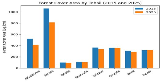
Figure 1 Tehsil-wise forest cover area in the Satpuda fringe of North Maharashtra for the years 2015 and 2025
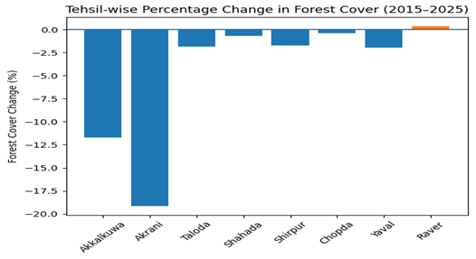
Figure 2 Tehsil-wise percentage change in forest cover in the Satpuda fringe of North Maharashtra during 2015–2025.
Results
The dynamic analysis of the forest cover in the Satpuda fringe of North Maharashtra in the year 2015 and 2025 shows a clear and spatially uneven trend of forest loss at the level of the tehsil (Table 1). In general, the absolute forest area (sq. km) and proportional forest cover (%) decreased in most tehsils, which indicates continuous pressure on forest resources in the decade.
The greatest absolute and relative loss is seen in the tribal and forested tehsils of Akrani and Akkalkuwa which comprise the largest share of Forest loss. Akrani documented a decline of 247.90 sq. km, which is equivalent to 19.14% decline in forest cover, and Akkalkuwa lost 109.25 sq. km (11.74%). Such losses suggest that there has been massive deterioration in regions that were once able to sustain thick forest cover. Conversely, tehsils like Taloda, Shahada, Shirpur, Chopda and Yaval have had a relatively moderate loss of between 0.38 percent to 1.95 percent, but the trend is always negative.
Spatially, loss of forests is higher in the north and northeast of the study area that borders the core Satpuda ranges (Akrani and Akkalkuwa), which implies increased anthropogenic pressure in ecologically sensitive areas. The tehsils of central and southern parts like Chopda and Shahada experience relatively low forest loss, indicating the lack of forest or comparatively high control of land-use change. The overall downward trend is broken by a slight increase of 3.42 sq. km (0.36%) in Raver, which has been due to afforestation efforts and plantation growth in the satellite-based data.
The high rate of forest loss in Akrani and Akkalkuwa is aligned to areas where there is increase in population, development of infrastructure and transformation of forest land into agricultural lands (Defries et al., 2010). The increase of subsistence and commercial agriculture, along with the increase of settlements, seems to be a major cause of forest depletion (Richards, 2015). Intensive agricultural development and irrigation in the Tehsils, including Yaval and Shirpur, also depict the observable forest decline, which further confirms the connection between the land-use change and the development processes (Ayele et al., 2019).
The witnessed reduction in forest cover is a major threat to sustainable development within the Satpuda fringe. Deforestation poses a threat to biodiversity, ecosystem services, and livelihood security of tribal communities that rely on forest resources. Although there are only positive changes in Raver, which indicate that it is possible to achieve positive results with the help of specific interventions, the overall trend shows that more integrated land-use planning, more robust forest protection, and more balanced economic growth and ecology should be developed. Overall, the findings indicate that forest loss within the Satpuda fringe between 2015-2025 is spatially clustered, development pressures are closely associated, and the outcomes have important long-term sustainable development implications in North Maharashtra.
Discussion
This research paper indicates that there has been a consistent decrease in the forest cover in the Satpuda fringe of North Maharashtra between 2015 and 2025, which is indicative of larger trends of land-use change in ecologically sensitive areas in India. The scale and geographical diversity of the forest loss experienced at the tehsil level highlight the interplay between the environmental resources and development pressures.
The intense deforestation of the Akrani and Akkalkuwa tehsils is especially important since these regions traditionally form the very heart of the forested and tribal-controlled terrain of the Satpuda ranges. These tehsils were susceptible to absolute losses as development pressures increased in 2015 due to a high initial forest cover. Agricultural expansion, fuelwood harvesting and infrastructure development particularly road connectivity and settlement expansion seem to be the major causes of deforestation in these areas (Lele & Joshi, 2008). Conversely, tehsils with relatively lower forest cover to start with like Chopda and Shahada had minimal change, which indicates that the availability of forests itself limits the extent of further loss (Bone et al., 2016).
The witnessed reduction in forest cover is directly linked with population increase and agricultural development especially in tehsils where subsistence farming and irrigated agriculture has encroached into marginal forest areas (Mulatu et al., 2025). Forest clearance in tribal tehsils to cultivate, build houses and other related activities is a manifestation of livelihood-driven land-use change and not industrial-scale deforestation. But this slow and diffused conversion has cumulative effects which are also of the first importance. The decline in forest cover in tehsils like Shirpur and Yaval also lends credence to the point that agricultural intensification and better irrigation infrastructure are some of the factors that lead to forest-to-agriculture conversion (Ali & Benjaminsen, 2004).
Sustainable development wise, the further depletion of forest cover is a cause of concern in terms of stability in the ecosystem, biodiversity protection and climate stability. The degradation of forests in the Satpuda fringe poses a threat to the important ecosystem services that include soil conservation, groundwater recharge, and the local climate regulation (Móstiga et al., 2024). To tribal communities, the reduced forest resources have a direct impact on food security, availability of non-timber forest products and the traditional livelihood systems. The fact that the percentage change in forest cover in Raver tehsil was positive indicates that afforestation efforts or plantation work or better forest management can produce positive results, but the magnitude of this improvement is very small.
The results highlight the importance of combined and region-specific land-use planning that balances the development goals with the conservation of the ecological environment (Rahma Febriyanti et al., 2022). Enhancing community-based forest management, agroforestry, and controlling agricultural activities on slopes covered with forests may reduce the loss further (Jeon et al., 2013). Also, remote sensing-based monitoring, as the one used in this study, is an efficient instrument of tracking forest dynamics and evidence-based policy-making.
Although the study is effective in capturing decadal cover changes in forests through the satellite data, it fails to capture all qualitative factors of the forests including forest degradation, fragmentation or species composition. Future studies are encouraged to combine socio-economic data, field data and longer time series data to capture the causes and effects of forest loss. The association of forest change with specific development indicators would also enhance the sustainability assessment of the Satpuda fringe. On the whole, the discussion highlights the fact that the loss of forests in the Satpuda fringe of North Maharashtra is not only an environmental problem but also a development problem that requires balanced, inclusive and sustainable planning strategies.
Conclusion
The current research gives a clear evaluation of the change in forest cover in the Satpuda fringe of North Maharashtra between 2015 and 2025 through a remote sensing method. The findings show that there is a general decrease in the forest cover in most of the tehsils, and especially in the areas of Akrani and Akkalkuwa, where there are severe losses, which point to these areas as the zones of the critical ecological exposure. The spatial analysis proves that the loss of forests is not evenly distributed and is closely associated with the local development processes.
The results show that forest depletion is strongly correlated with the indicators of development like population growth, agricultural expansion, and infrastructure development. Although these processes have led to socio-economic enhancement, they have also increased the strain on the forest ecosystems, particularly in tribal dominated and forest endowed tehsils (Chettri et al., 2007). The fact that the marginal increase in forest cover in Raver tehsil was observed indicates that specific conservation initiatives, afforestation efforts, and proper land management can have positive results, yet these efforts are not widespread in the area (Clark et al., 2021).
In terms of sustainable development, further loss of forests is a major threat to the conservation of biodiversity, ecosystems, and livelihood security of communities that rely on forests. The research highlights the importance of considering the environment in the planning of regional development. The community-based forest management, agro forestry practices and controlled land use change policies are necessary to balance the development requirements with the ecological sustainability.
To sum up, remote sensing is a useful and trustworthy means of monitoring forest dynamics and helping to make informed decisions. The development strategies in the Satpuda fringe of North Maharashtra should not be focused on short-term economic benefits, but should be integrated to ensure that forest resources are protected and at the same time, the socio-economic needs are met to ensure long-term sustainability.
References
- Ali, J., & Benjaminsen, T. A. (2004). Fuelwood, Timber and Deforestation in the Himalayas. Mountain Research and Development, 24(4), 312–318. https://doi.org/10.1659/0276-4741(2004)024[0312:ftadit]2.0.co;2
- Ayele, G., Hayicho, H., & Alemu, M. (2019). Land Use Land Cover Change Detection and Deforestation Modeling: In Delomena District of Bale Zone, Ethiopia. Journal of Environmental Protection, 10(04), 532–561. https://doi.org/10.4236/jep.2019.104031
- Bas, T. G., Sáez, M. L., & Sáez, N. (2024). Sustainable Development versus Extractivist Deforestation in Tropical, Subtropical, and Boreal Forest Ecosystems: Repercussions and Controversies about the Mother Tree and the Mycorrhizal Network Hypothesis. Plants, 13(9), 1231. https://doi.org/10.3390/plants13091231
- Behera, R. N., Nayak, D. K., Andersen, P., &Måren, I. E. (2015). From jhum to broom: Agricultural land-use change and food security implications on the Meghalaya Plateau, India. Ambio, 45(1), 63–77. https://doi.org/10.1007/s13280-015-0691-3
- Bone, R. A., Parks, K. E., Hudson, M. D., Tsirinzeni, M., & Willcock, S. (2016). Deforestation since independence: a quantitative assessment of four decades of land-cover change in Malawi. Southern Forests: A Journal of Forest Science, 79(4), 269–275. https://doi.org/10.2989/20702620.2016.1233777
- Chettri, N., Sharma, E., Shakya, B., & Bajracharya, B. (2007). Developing Forested Conservation Corridors in the Kangchenjunga Landscape, Eastern Himalaya. Mountain Research and Development, 27(3), 211–214. https://doi.org/10.1659/mrd.0923
- Clark, B., Defries, R., & Krishnaswamy, J. (2021). India’s Commitments to Increase Tree and Forest Cover: Consequences for Water Supply and Agriculture Production within the Central Indian Highlands. Water, 13(7), 959. https://doi.org/10.3390/w13070959
- Defries, R. S., Rudel, T., Uriarte, M., & Hansen, M. (2010). Deforestation driven by urban population growth and agricultural trade in the twenty-first century. Nature Geoscience, 3(3), 178–181. https://doi.org/10.1038/ngeo756
- Gautam, A. P., Webb, E. L., &Eiumnoh, A. (2002). GIS Assessment of Land Use/Land Cover Changes Associated with Community Forestry Implementation in the Middle Hills of Nepal. Mountain Research and Development, 22(1), 63–69. https://doi.org/10.1659/0276-4741(2002)022%5B0063: gaolul]2.0.co;2
- Giriraj, A., Irfan-Ullah, M., Murthy, M. S. R., &Beierkuhnlein, C. (2008). Modelling Spatial and Temporal Forest Cover Change Patterns (1973-2020): A Case Study from South Western Ghats (India). Sensors (Basel, Switzerland), 8(10), 6132–6153. https://doi.org/10.3390/s8106132
- Islomov, S., Aslanov, I., Shamuratova, G., Jumanov, A., Allanazarov, K., Daljanov, Q., Tursinov, M., &Karimbaev, Q. (2023). Monitoring of Land and Forest Cover Change Dynamics Using Remote Sensing and GIS in Mountains and Foothill of Zaamin, Uzbekistan (pp. 1908–1914). Springer. https://doi.org/10.1007/978-3-031-21219-2_212
- Lele, N., & Joshi, P. K. (2008). Analyzing deforestation rates, spatial forest cover changes and identifying critical areas of forest cover changes in North-East India during 1972–1999. Environmental Monitoring and Assessment, 156(1–4), 159–170. https://doi.org/10.1007/s10661-008-0472-6
- Mani, J. K., & Varghese, A. O. (2018). Remote Sensing and GIS in Agriculture and Forest Resource Monitoring (pp. 377–400). Springer. https://doi.org/10.1007/978-3-319-78711-4_19
- Móstiga, M., Armenteras, D., Vayreda, J., & Retana, J. (2024). Two decades of accelerated deforestation in Peruvian forests: a national and regional analysis (2000–2020). Regional Environmental Change, 24(2). https://doi.org/10.1007/s10113-024-02189-5
- Mulatu, K., Hundera, K., &Senbeta, F. (2025). Analysis of Forest Cover Change in the Southwest Ethiopia: Key Drivers, Impacts, and Conservation Implications. International Journal of Forestry Research, 2025(1). https://doi.org/10.1155/ijfr/5523008
- Rahma Febriyanti, A., Tri Ratnasari, R., &Wardhana, A. K. (2022). The Effect of Economic Growth, Agricultural Land, and Trade Openness Moderated by Population Density on Deforestation in OIC Countries. Quantitative Economics and Management Studies, 3(2), 221–234. https://doi.org/10.35877/454ri.qems828
- Richards, P. (2015). What Drives Indirect Land Use Change? How Brazil’s Agriculture Sector Influences Frontier Deforestation. Annals of the Association of American Geographers, 105(5), 1026–1040. https://doi.org/10.1080/00045608.2015.1060924
- Stamatopoulos, I., Le, T. C., & Daver, F. (2024). UAV-assisted seeding and monitoring of reforestation sites: a review. Australian Forestry, 87(2), 90–98. https://doi.org/10.1080/00049158.2024.2343516
- Syamsih, D. (2024). Impacts of Deforestation on Soil Quality and Water Resources in Tropical Forest Areas of Sumatra. Journal of Horizon, 1(1), 16–22. https://doi.org/10.62872/kvmcwq82
- Zurqani, H. A., Post, C. J., Mikhailova, E. A., & Allen, J. S. (2019). Mapping Urbanization Trends in a Forested Landscape Using Google Earth Engine. Remote Sensing in Earth Systems Sciences, 2(4), 173–182. https://doi.org/10.1007/s41976-019-00020-y

You must be logged in to post a comment.