Navigation with Indian Constellation (NavIC), also called the Indian Regional Navigation Satellite System (IRNSS), is considered on par with US-based GPS, Russia’s Glonass and Galileo developed by Europe.
Making innovative applications to the entire community in the ocean-based services, especially for the underserved and unserved, the NavIC constellation is really going to create history, according to ISRO Chairman K Sivan.
By using receivers on the ground, IRNSS-1I will help in determining position and time accurately through signals in a space covering India.
Standard Positioning Service (SPS) and Restricted Service (RS), which are provided to all and authorised users respectively, are the services associated with IRNSS.
Indian Prime Minister Narendra Modi named the independent regional navigation satellite system developed by India as “NavIC” which offers services like terrestrial and marine navigation, disaster management, vehicle tracking and fleet management, a navigation aid for hikers and travellers, visual and voice navigation for drivers.
Built at a cost of $174 million, NavIC was originally approved in 2006 and became operational in 2018.
Consisting of eight satellites, NavIC is currently being used for providing emergency warning alerts to fishermen venturing into the deep sea where there is no terrestrial network connectivity and in public vehicle tracking in India.
In order to ensure the availability of NavIC signal in any part of the world, India’s satellite navigation draft policy in 2021 stated the government will work towards “expanding the coverage from regional to global.”
With the aim of removing dependence on foreign satellite systems for navigation service requirements, NavIC is conceived particularly for “strategic sectors.”
Government says, India’s satellite-based navigation system, NavIC, is as good as GPS of the United States in terms of position accuracy and availability in its service region.
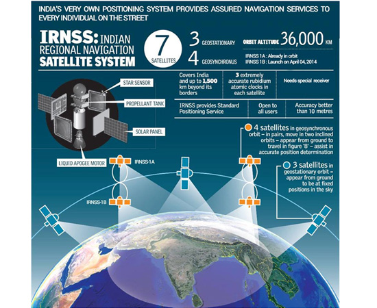
The Indian Regional Navigation Satellite System, with an operational name of NavIC, is an autonomous regional satellite navigation system that provides accurate real-time positioning and timing services. It covers India and a region extending 1,500 km around it, with plans for further extension.
Replying to a question in the Rajya Sabha, Union Minister of State (Independent Charge) Science & Technology; Minister of State (Independent Charge) Earth Sciences; MoS PMO, Personnel, Public Grievances, Pensions, Atomic Energy and Space, Dr Jitendra Singh said,
NavIC can help in navigation on land, air, sea and also in disaster management.
NavIC satellites are placed at a higher orbit than the GPS of United States. NavIC satellites are placed in geostationary orbit (GEO) & geosynchronous orbit (GSO) with an altitude of about 36,000 km; GPS satellites are placed in medium earth orbit (MEO) with an altitude of about 20,000 km.
NavIC uses dual frequency bands, which improves accuracy of dual frequency receivers by enabling them to correct atmospheric errors through simultaneous use of two frequencies. It also helps in better reliability and availability because the signal from either frequency can serve the positioning requirement equally well.
At the time of inception, an indigenously developed satellite navigation system was conceptualized to cater to requirements of critical national applications, including those of defence and commercial establishments. Hence the coverage area was designed to cover Indian Territory and surrounding 1500 km of Indian borders. The needs of critical national applications do evolve with time and efforts are continuously made to meet these requirements, including from the point of view of coverage.
Navic is an independent Indian Satellite based positioning system for critical National applications. The main objective is to provide Reliable Position, Navigation and Timing services over India and its neighbourhood, to provide fairly good accuracy to the user. The IRNSS will provide basically two types of services
Standard Positioning Service (SPS)
Restricted Service (RS)
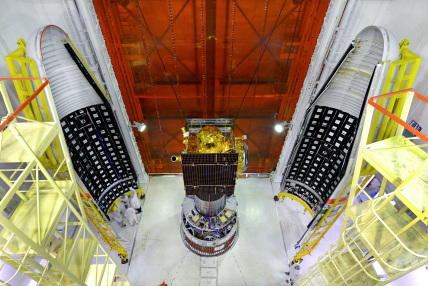
To date, ISRO has built a total of nine satellites in the IRNSS series; of which eight are currently in orbit Three of these satellites are in geostationary orbit (GEO) while the remaining in geosynchronous orbits (GSO) that maintain an inclination of 29° to the equatorial plane. The IRNSS constellation was named as “NavIC” (Navigation with Indian Constellation) by the Honourable Prime Minister, Mr. Narendra Modi and dedicated to the nation on the occasion of the successful launch of the IRNSS-1G satellite. The eight operational satellites in the IRNSS series, namely IRNSS-1A, 1B, 1C, 1D, 1E, 1F, 1G and 1I were launched on Jul 02, 2013; Apr 04, 2014; Oct 16, 2014; Mar 28, 2015; Jan 20, 2016; Mar 10, 2016, Apr 28, 2016; and Apr 12, 2018 respectively. The PSLV-39 / IRNSS-1H being unsuccessful; the satellite could not reach orbit.
Credit: Third Party Reference
Oh, Did I just ask to not address NAVIC (Navigation with Indian Constellation) as our own GPS (Global Positioning System). Have I lost my mind to go against the trend media has created? Am I actually serious about it? Well, let’s see why I am making such a preposterous appeal.
I have realised while talking to a lot of people on social media that they think GPS is a technology per say in generic terms which is completely incorrect. And the headlines all over media are reflecting as such. So first let’s talk about different satellite based navigation systems.
WHAT IS GPS :-
GPS (Global Positioning System) is a global satellite-based navigation system made up of a network of 24 satellites placed into orbit by the U.S. Department of Defense (DoD). It is a U.S.-owned utility that provides users with positioning, navigation, and timing (PNT) services. This system consists of three segments: the space segment, the control segment, and the user segment. GPS is operated and maintained by the U.S. Air Force. It is currently the world’s most utilized satellite navigation system.
ABOUT GNSS :-
The generic name of what we assume to be GPS is GNSS (Global Navigation Satellite System). Currently there are two operational GNSS: 1) Global Positioning System (GPS) is owned by the United States. 2) GLONASS is owned by Russia.
The third GNSS- GALILEO of European Union isn’t completely operational yet, 12 of 30 satellites in orbit. The forth BeiDou (Chinese Navigation system) is a limited test system, its full-scale global navigation system or GNSS also known as COMPASS or BeiDou-2 is currently under construction, it has about 20 satellites in orbit at present.
THEN WHAT’S THE ISSUE?
See, by now we have developed GPS isn’t a generic term, it’s just most popular and we human race runs after something that’s always more popular and it’s exactly what needs to be changed if we want to create our own identity in this world, if we want to stand with pride, if we want other nations to respect and recognise us then we need to be own people and not some ripped off identity of other nation and that’s what NAVIC deserve.
Credit: Third Party Reference
NAVIC was developed after so much of continuous handwork of ISRO scientists, thorough research and loads of money. It isn’t just another satellite based navigation system, it made us the fifth elite nation in this world to have our own navigation satellite system and it is a big deal. I am forever grateful to GPS for extending its services to us but we (India) developed and deployed NAVIC because many of the GPS services weren’t available to defence forces specially and we needed that thus came NAVIC.
“NAVIC made us a proud nation, it showed the world the powerful force India is, it showed that we were Inventers/developers, we are and we always will be. We have some of the best brains in the world that is what NAVIC represents. It’s our pride and giving it a second hand name just dishearten me and it should dishearten you as well.
China has its own search engine Baidu and they do not call it ‘Chinese Google’. We do not call Flipkart as ‘India’s Amazon’ or Ola as ‘India’s Uber’ or every Smartphone an iPhone. Even you wouldn’t like to be called by other’s names!
What we say today, what we trend today will be remembered tomorrow and I do not want NAVIC to be known as ‘Indian GPS’.
If you agree with me then kindly share this post, raise your voice, talk about it, and aware more people about it. All I want is NAVIC to be known as NAVIC to the entire world and I need your help in doing so.
Reference-divyanshspacetech.wordpress.com and isro.gov.in


You must be logged in to post a comment.