

Author: Admin
Track2Training for students. Learn more on https://track2training.com
ISRO Announces Free Online Course With Certificates on Remote Sensing, GI System

ISRO has announced a five-day free online course on remote sensing and GIS, being conducted by IIRS for government officials, policy-makers, and research scholars. Read on for more details to apply.
Sounds Interesting? Share it now!
The Indian Space Research Organisation (ISRO) has invited applications for a free online course called RS and GIS Applications in Atmospheric and Oceanic Hazards. The five-day course has been organised by the Indian Institute of Remote Sensing (IIRS) under ISRO.
The course has been designed for all stakeholders that need to be aware of natural and man-made disasters — such as tsunamis, cyclones, floods, storm surges, extreme rainfall, and dust storm. It will provide participants with an overview of utilising remote sensing and GIS data to avert them.
The curriculum is suitable for central and state government officials, policymakers, professionals and specialists from universities, educational institutes, operational and research institutes, and research scholars.
Things to know
The course is free.
The course can be completed in five days.
Course study materials, such as lecture slides and video-recorded lectures, will be made available through e-class.
There is a limited number of seats available. Registration will be done on a first come first serve basis.
A certificate will be given to the participants who have 70 percent attendance in the course.
How to apply
Applications will be submitted online.
To participate in this programme, the interested organisations, universities, departments, and institutes have to identify a coordinator at their end.
The identified coordinator will have to register his/her institute as a nodal centre on the IIRS website.
The course can then be taken by registered participants through the e-class platform of IIRS-ISRO.
Important dates
The course will begin on 27 February 2023 and end on 3 March 2023.
Use this link for Registration
For more information, check the official notification.
Maa Kalijai Temple; Beauty of Chilika Lake
Chilika Lake is a brackish water lagoon located in the state of Odisha, India. It is the largest coastal lagoon in India and the second largest in the world. The lake is spread over an area of 1,100 square kilometers and has a unique ecosystem that supports a wide variety of flora and fauna. It is home to over 160 species of birds, including several migratory species that visit the lake during the winter months. The lake is also home to a variety of fish, crustaceans, and other aquatic animals. The lake’s ecosystem is highly productive, and it supports the livelihoods of thousands of people who depend on the lake for fishing, farming, and other activities.
Chilika Lake is also an important tourist destination and is known for its natural beauty and biodiversity. Visitors can take boat rides on the lake and observe the various bird species and other wildlife that inhabit the area. The lake is also home to several small islands that are popular among tourists.
Hisory of Maa Kalijai Temple
Kalijai Temple is a famous Hindu temple located on an island in Chilika Lake in the state of Odisha, India. The temple is dedicated to the goddess Kalajai, who is considered to be an incarnation of the goddess Kali.
According to legend, a newly married girl (named Jaai) and her father were on their way to meet her husband. Her in-house law’s was on an island in Chilika Lake, so they had to take a boat across the lake to get there. The coast of Odisha is prone to cyclones, and during this boat trip, they encountered a severe cyclone, causing their boat to capsize in Chilika Lake. Except for the girl Jaai, all of the boatmen and her father survived this incident. They looked for her but couldn’t find her. After the untimely death of that newlywed girl, she became the Goddess of the people who lived nearby, and she is still worshipped as an Excerpt of Kali. And, this is how the place got its name.

The temple is located on an island in the middle of Chilika Lake, and can only be reached by boat. Visitors to the temple can enjoy the scenic boat ride across the lake and take in the natural beauty of the area. The temple is also home to a variety of wildlife, including several species of birds, which can be seen on the island and in the surrounding water.
The Kalijai Temple is a popular pilgrimage site for devotees of the goddess Kalijai, who come from all over India to offer prayers and seek blessings. The temple is particularly crowded during the annual festival of Kalijai, which is held in the month of November and attracts thousands of devotees.
The temple is also a popular tourist attraction, and visitors can explore the temple complex and learn about the history and legends associated with the temple. The beautiful architecture of the temple, the scenic surroundings, and the spiritual atmosphere make it a must-visit destination in Odisha.
7 Challenges of Urban Planning in India by Dr Ashok kumar
Second World War(1939- 1945)
World War II was a global conflict that lasted from 1939 to 1945. It was the deadliest conflict in human history, with an estimated 50-85 million fatalities worldwide, including civilians and military personnel. The war was fought between two main alliances: the Axis powers, consisting of Germany, Italy, and Japan; and the Allied powers, consisting of the United States, Great Britain, France, and the Soviet Union, among others.
The war began on September 1, 1939, when Germany invaded Poland. Britain and France, who had guaranteed Poland’s security, declared war on Germany on September 3. The early years of the war were marked by German victories in Europe and the rapid expansion of the Axis powers, including the invasion of the Soviet Union in 1941.
The tide of the war began to turn in favor of the Allies in 1942, with significant victories in North Africa and the Soviet Union. In 1944, Allied forces landed in Normandy and began the liberation of Western Europe. The war in Europe ended on May 8, 1945, when Germany surrendered.
The war in the Pacific continued until August 15, 1945, when Japan announced its surrender after atomic bombs were dropped on the cities of Hiroshima and Nagasaki by the United States.
The aftermath of the war led to significant changes in the political and social landscape of the world, including the formation of the United Nations and the beginning of the Cold War between the Western powers and the Soviet Union.

Source – Wikipedia
Causes of World War II:
1. The Treaty of Versailles (1919): The treaty of Versailles had in itself the germs of the Second World War. The Germany was very badly treated. She was forced to sign the treaty at the point of a bayonet, in a spirit of revenge. To tear away the treaty of Versailles, Hitler joined hands with Mussolini of Italy.
2. Nationalist Movements of Germany & Italy: The rise of the national movement in Germany & Italy added fuel to the fire. Although Hitler tried to assure the world that he meant peace, he could not conceal his ambition for long. He embarked on a career of aggression which ultimately lead to war. The same was the case with Mussolini who had established his dictatorship in Italy in 1922.
3. Conflict of Ideology between Dictatorship & Democracy: Countries like Germany, Italy & Japan represented the ideology of dictatorship while Great Britain, France & USA represented the ideology of democracy. Mussolini described the conflict between the two ideology thus: ‘The struggle between the two worlds can permit no compromise. Either we or they’
4. Inefficiency of League of Nations: Unfortunately, when hostility was growing between the two camps there was no effective international organization which could bring the leaders of the two camps on a common platform and bring about a reconciliation between them. The League of Nations was practically dead.
5. Colonial & Commercial Rivalry: The colonial and commercial rivalry between England and France on one side, and Germany and Italy on the other brought them in conflict with each other.
6. Aggressiveness of Berlin-Rome-Tokyo Axis : Hitler had became very aggressive. He annexed the Saar Valley, occupied Rhineland and Austria captured Czechoslovakia etc. Mussolini attacked Abyssinia (Ethiopia) Japan attached China. This aggressive mood of the Fascist Power got its fullest expression when they formed an Axis providing for mutual aid in the international sphere.
7. Immediate Cause: The immediate cause of the war was the refuse of Poland to Surrender. Germany gave an ultimatum to Poland regarding : (i) surrender the port of Dazing, (ii) the right of establishing a rail link between Germany and East Prussia through the Polish corridor. These two demands were rejected by Poland. So Germany invaded Poland on Sept. 1, 1939. Britain and France as they were under treaty obligations to aid Poland, declared war against Germany on Sept. 3, 1393.
Bronze Age Civilization
The Bronze Age was a period of human history that began around 3000 BCE and lasted until around 1200 BCE. During this time, many civilizations emerged and developed in various parts of the world. Some of the most well-known Bronze Age civilizations include:
-
Mesopotamian Civilization: The Oldest Civilization of the world Mesopotamia means land between the rivers. Mesopotamia is the land that developed in the region between the Tigris and Euphrates rivers is often referred to as the cradle of civilization.
-
Egyptian Civilization: The civilization that developed along the Nile River in northeastern Africa is one of the most famous Bronze Age civilizations. The ancient Egyptians developed a sophisticated system of writing, art, architecture, religion, and government that influenced later cultures.
-
Indus Valley Civilization: This Bronze Age civilization developed in the northwestern region of the Indian subcontinent around 2500 BCE. The Indus Valley Civilization was known for its advanced urban planning, including a complex system of drainage and water management.
-
Chinese Civilization: The Shang Dynasty was a Bronze Age civilization that developed in China around 1600 BCE. The Shang Dynasty is known for its sophisticated system of writing, bronze metallurgy, and art.

Source – flagfen.com
Mesopotamian Civilization:
The Mesopotamian civilization emerged in the region that is now Iraq around 4000 BCE and lasted until the 6th century BCE. It is known as one of the earliest civilizations in the world, and its contributions to human history are numerous.
The Mesopotamians developed a system of writing called cuneiform, which involved pressing a reed stylus into clay tablets to create wedge-shaped marks. This system allowed for the recording of laws, contracts, and other important documents, making it possible to keep records and communicate across long distances.
The potter’s wheel was perhaps first used in Mesopotamia. They also developed the first written legal code, the Code of Hammurabi, which established a set of laws and punishments for crimes. They had discovered the Pythagoras Theorem and could also calculate the length of day and night.
Overall, the Mesopotamians were a highly influential civilization, and their innovations and achievements continue to shape the world today.
Egyptian Civilization:
The Egyptian civilization emerged along the Nile River and hence, Egypt is called the ‘Gift of the Nile’. The Old Kingdom is also called as the ‘Age of the Pyramids’. The Egyptians built impressive structures, including the pyramids, temples, and palaces. These structures were designed to honor the pharaohs, who were considered to be divine rulers.
The Egyptians had a complex religion, which included a pantheon of gods and goddesses, each of whom controlled different aspects of the natural world. They believed in the afterlife and developed elaborate burial practices, including the construction of tombs and the preservation of bodies through mummification.
The Egyptians also made significant contributions to mathematics and science, including the development of geometry, astronomy, and medicine. They developed a decimal system of numeration. The crowing achievement of the Egyptians was the Solar Calendar.
Overall, the Egyptian civilization was one of the most influential and long-lasting in human history, leaving behind a rich legacy of art, architecture, literature, and culture that continues to inspire us today.
Indus Valley Civilization:
The Indus Valley Civilization (also known as the Harappan Civilization) was an ancient civilization that flourished in the northwestern region of the Indian subcontinent from approximately 2600 BCE to 1900 BCE. It was named after the Indus River, which flows through the region.
The Indus Valley Civilization was one of the world’s earliest urban civilizations, and it had a highly sophisticated culture with a well-developed system of writing, impressive architecture, and advanced agricultural techniques. The cities of the Indus Valley Civilization were also notable for their efficient drainage systems, which were among the most advanced of their time.
Some of the major cities of the Indus Valley Civilization included Harappa, Mohenjo-Daro, and Dholavira, which were all located in present-day Pakistan. The civilization also had extensive trade networks that reached as far as Mesopotamia, Central Asia, and the Persian Gulf.
Despite its significant achievements, much about the Indus Valley Civilization remains a mystery, as the script used by the civilization has yet to be fully deciphered, and there is still much debate about the reasons for its decline and ultimate collapse.
Chinese Civilization:
Chinese civilization is one of the world’s oldest, dating back to around 2100 BCE. The civilization emerged in the Yellow River Valley of China and has contributed immensely to the world in fields such as philosophy, art, science, and technology.
The early Chinese civilization was characterized by a series of dynasties, which were ruled by emperors and marked by significant achievements in technology, art, and literature. The Shang Dynasty (1600 BCE-1046 BCE) was known for its bronze casting, oracle bone inscriptions, and advanced agriculture.
The Chinese civilization is also known for its significant contributions to philosophy, including the teachings of Confucius, Taoism, and Buddhism. Confucianism emphasizes the importance of moral values and ethics, while Taoism emphasizes the importance of harmony and balance in nature. Buddhism was introduced to China in the 1st century CE and became an influential religion in the country.
In the field of science and technology, the ancient Chinese civilization made significant contributions in areas such as astronomy, mathematics, medicine, and engineering. The Chinese were among the first to develop gunpowder, paper, printing, and the compass, which had a significant impact on the world.
Overall, Chinese civilization has had a profound impact on the world, with its contributions in various fields shaping the course of human history.
Fundamental Rights and Fundamental Duties for Indian Citizens
India is well-known for its cultural diversity. This great nation’s identity is formed by many religions, cultures, and languages. Along with this diversity, India has been the site of several significant political movements. The struggle for independence from British rule was one of these movements. Following our country’s independence in 1947, our leaders worked tirelessly to draught a constitution that would protect the rights of all citizens. The Indian Constitution is a document that discusses the fundamental rights and duties of Indian citizens. In this article, we will look at these fundamental rights in greater detail!

Picture Courtesy – https://www.nicholls.edu/
What are the fundamental rights?
The fundamental rights are the fundamental rights guaranteed to all Indian citizens by the Constitution. Part III of the Constitution enshrines these rights ( Articles 12-35). Fundamental rights are not absolute, but are subject to reasonable limitations. Every Indian citizen is guaranteed seven fundamental rights under the Indian Constitution.
Article 12-35 of the Indian constitution establishes seven fundamental rights. It includes the right to equality (Article 14-18), the right to freedom (Article 19-22), the right against exploitation (Article 23-24), the right to religious freedom (Article 25-28), cultural and educational rights (Article 29-30), the right to property (Article 31), and the right to constitutional remedies (Article 32). (Article 32). Courts have the authority to enforce fundamental rights, subject to reasonable limitations.
- Right to Equality (Article 14-18): The right to equality includes the prohibition of discrimination on the basis of caste, race, place of birth, sex, religion, and equal opportunity for employment.
- Right to Freedom (Article 19-22): These rights include the freedom to speak freely and express yourself, the right to form associations, unions, or cooperatives, the right to move, reside, and work.
- Right against Exploitation (Articles 23-24): This includes protection from human trafficking and forced labor.
- Right to Freedom of Religion (Articles 25-28): This right includes the freedom to choose, practice, and promote the religion of your choice.
- Cultural and Educational Rights (Articles 29-30): These rights include the right to protect minorities’ interests as well as the right to preserve their language, script, or culture.
- Right to Property (Article 31): The 44th Amendment Act of 1978 abolished this right and replaced it with a legal right under Article 300A.
- Right to Constitutional Remedies (Article 32): This is the most important right because it grants the authority to petition the Supreme Court for the enforcement of Fundamental Rights.
- Fundamental rights are not absolute, but are subject to reasonable limitations, as stated in the constitution. Except in declared emergencies, these rights cannot be waived.
What are the fundamental duties under the Indian constitution?
The fundamental duties of citizens under the Indian Constitution are mentioned in Part IVA of the constitution. They were added by the 42nd Amendment in 1976. The amendment was done to instill a sense of patriotism and national pride in the citizens. There are ten fundamental duties mentioned in the constitution.
These fundamental duties are not enforceable by law but the constitution aims to inculcate a sense of duty in every citizen. Some of the fundamental duties include:
– protect our composite culture’s rich heritage;
– protect our country and provide national service whenever the government requests it.
– promote harmony and a sense of common brotherhood among the people of India, regardless of regional, linguistic, or religious differences.
– value and preserve our country’s rich biodiversity;
– protect mother earth as well as rivers, wildlife, forests, and lakes.
– protect public property and avoid violence;
Apart from the fundamental duties mentioned above, Indian citizens are also required to perform additional duties.
Differences between fundamental rights and fundamental duties:
The major difference between fundamental rights and fundamental duties is that fundamental duties are binding on all citizens, whereas fundamental rights are not.
–The Fundamental Rights, as defined in Part III of the Constitution, are all citizens’ basic civil and political rights.
– The Fundamental Duties, as defined in Part IVA of the Constitution, are non-mandatory obligations that are regarded as moral obligations.
– The courts can enforce the Fundamental Rights, but not the Fundamental Duties.
– The Fundamental Duties were added to the Constitution recently, whereas the Fundamental Rights have been present since its inception.
Conclusion:
The Fundamental Rights are a set of rights to which all Indian citizens are entitled. These rights are enshrined in the Indian Constitution and protect the individual from abuse by both the government and private individuals and organizations. I tried to outline the seven fundamental rights that all Indians have, define fundamental duties, and differentiate between fundamental rights and fundamental duties in this blog post.
How to Write a Research Paper for Publication in SCI
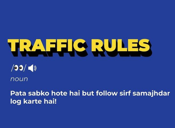
Traffic Rules and Regulations
In 1914, the first legislation ‘Indian Motor Vehicle Act 1914’ was passed in our country to regulate the motor vehicles and as well as other road users. Since then, traffic pressure on Indian roads has multiplied several times, and the first Motor Vehicle Act 1914 has been amended and revised several times by the Government of India to form the ‘The Motor Vehicle Act 1988’. Traffic rules and regulations are designed to ensure the smooth flow of motor vehicles on the road, which includes not only drivers but also pedestrians, cyclists, hand carters, and other road users. Drivers and other road users must have a thorough understanding of traffic rules/regulations, traffic signs, and markings. The proper understanding of these rules can significantly reduce the number of accidents while also establishing a healthy and well-organized traffic system in our country.
Both pedestrians and the drivers should be disciplined & obey all the rules and regulations. So, I request every citizen of this country to follow the do’s and don’ts listed down below for pedestrians and drivers, respectively.
DO’s for pedestrians –
- DO walk in a straight line down the sidewalk.
- DO stop at crosswalks and pay attention to the signals.
- DO pay attention to your surroundings when walking, especially at night and alone.
- DO take the time to enjoy your walk even if you are in a hurry… look around and see.
- DO smile if you happen to make eye contact with another human being.
DON’Ts for pedestrians –
- DON’T stop randomly on the sidewalk without checking that people are right behind you.
- DON’T jaywalk without looking.
- DON’T wear headphones and have your music turned up so loud you can’t hear what’s happening on the street.
- DON’T cut across the sidewalk to get to a shop or something without looking behind you.
- DON’T walk into things while your head is down looking at your phone… trust me, it happens!
DO’s while driving –
- Do always wear a helmet while riding a 2 wheeler.
- Do always wear a seat belt.
- Do follow the speed limit.
- Do be courteous towards other drivers and riders.
- Do give pedestrians the right-of-way in crosswalks.
- Do make room for bicycles.
- Do pay attention while driving, even if you are familiar with the area. A surprising number of accidents take place only blocks away from home!
- Do use indicators.
- Always keep to the left.
- Do keep a safe distance.
- Do always carry the important papers and your driving license.
- Do drive cautiously in severe weather.
- Do plan your long route journeys in advance. Take proper gaps in between.
DON’Ts while driving –
- Don’t drive alcohol and drive, and don’t get in a car with a driver who has been drinking or using drugs.
- Don’t talk on your cell phone and drive at the same time. If you need to make or answer a call, pull over at a safe place and then resume your journey.
- Don’t let your emotions and frustrations get the best of you. Don’t engage in road rage, no matter how irritating another driver might be to you.
- Don’t tailgate other cars, pass on shoulders, run stoplights or stop signs, or break any other rules on purpose.
- Don’t drive if you are underage.
- Don’t overtake suddenly.
- Don’t use brakes suddenly.
- Don’t overspeed over potholes.
Using Modeling and Simulation to Test Designs and Requirements
Modeling is an efficient and cost-effective way to represent a real-world system. A model can represent key aspects of the system, including the underlying requirements, the components, and how those components communicate with one another. The model can be simulated, enabling designers to test designs before hardware is available, or to test conditions that are either difficult or expensive to replicate in the real world. Iterating between modeling and simulation can improve the quality of the system design early, reducing the number of errors found later in the design process.
Despite these advantages, designers who heavily rely on hand coding do not always take full advantage of modeling and simulation. Setting up tests can be difficult and time-consuming, and when separate tools are used for each domain, it can be challenging to obtain a system-level view of the design. As a result, defects that could have been found in the modeling and simulation phase are often found during the implementation phase, when defects are more expensive to fix.
These issues are addressed in Simulink®, a platform for modeling and simulation. Simulink supports not only multidomain modeling but also simulation, with its own set of ordinary differential equation (ODE) solvers. A fundamental advantage of using Simulink is that you can represent different domains, including control systems, state machines, and environmental models, in one model, and then run simulations within Simulink to verify that the model is built correctly. As the simulation runs, you have access to simulation analysis capabilities, such as data displays, state animation, and conditional breakpoints. After the simulation is completed, you can analyze any logged data with MATLAB® scripts and visualization tools.
In this article, we describe a workflow for building a component model from requirements, simulating and testing that component model, and then connecting it to a system-level model for further simulation and testing. To illustrate this workflow we will build and test the fault detection, isolation, and recovery (FDIR) component of the HL-20, a re-entry vehicle designed by NASA to complement the Space Shuttle orbiter. We will connect our component to a system-level model that includes environmental models, flight controls, and guidance, navigation, and controls (GN&C) systems, and then simulate the system-level model to validate its behavior.

What is Simulation Modelling
SN Sharma (2022) has rightly stated that “Simulation is a well designed model which should be representative of real world like situation, it can be done after taking into account all components with well-defined (cohesive) functions, and minimised dependencies on other component which can be done after getting thorough knowledge of the functioning conditions of the model.”

Automated Reproducibility
Being able to recreate any run of the software—for testing purposes and to check claims about its outputs—in an automated way (not just via manual recreation from documentation). This includes provenance (and perhaps automated recreation) of the entire computational environment (since results can vary based on things like the versions of external libraries used).
Cohesive, Loosely-Coupled Design
A design separated into components with well-defined (cohesive) functions, and minimised dependencies on other components (loose-coupling). This massively aids the debugging, maintenance and reusability of the code. This often involves reusing recurring structural and behavioural forms that have been shown to help solve common design issues: SE calls such forms design patterns (Gamma et al. 1995; Buschmann 1996). Such forms help establish a shared software design vocabulary at a higher level of abstraction.
Testability
Being designed in a way that facilitates testing at different levels (e.g., single class, component or whole system) and, where possible, includes automated tests as part of the software deliverable. In particular, automated tests provide a bank of regression tests which can be continually re-run to check that changes have not caused bugs elsewhere (i.e., caused previously successful tests to fail). Such tests become the central driver of the development process in the increasingly-used Test-Driven Development (TDD) approach (Jeffries & Melnik 2007).
However, there appears to be virtually no discussion of these issues more generally for ‘mainstream’ simulation using widely-used toolkits such as, in the ABM case, NetLogo (Tisue & Wilensky 2004), Repast Simphony (North et al. 2013), MASON (Luke et al. 2005), or AnyLogic (Borshchev & Filippov 2004). In particular, there is nothing which allows simulation practitioners to understand how these ideas might be embodied in some best-practice simulation design, and to therefore have some frame to assess existing toolkits and make more informed decisions on their choice of simulation platform (and thus understand the strengths and weaknesses of their simulation software design with respect to this best-practice).
Utilities.
General utilities (not specific to the domain model or upper layers) for (a) data types (e.g., linked lists); (b) input/output capabilities, such as to/from different file formats; and (c) general algorithmic facilities such as random number generators, probability distributions or differential equation numerical solvers. These can interact; e.g., probability distributions could be initialised from external files.
Domain Model.
The code representing the abstraction of the real-world system, including the representation of space and time.
Execution Control.
How the domain model is actually executed, which typically amounts to instantiating a ‘root’ object and stepping through a schedule of actions (provided by a domain model component) to ‘unfold’ time dynamically. Because non-domain-model objects also need to interleave their actions in simulated time, this layer includes that capability. This is a ‘thin’ layer, but nevertheless a well-defined one.
Meta-Data Capture.
Code (scheduled in simulation time) to capture and calculate meta-data; i.e., derived model state (possibly held as a time series to capture changes over time) or atomic model state captured over time.
This layer includes any writing of outputs to file (or database) because this can be tightly coupled with meta-data capture; in larger-scale simulations, time series data may be captured in a rolling window for storage reasons (perhaps with this window used for visualisation), with outputs written to file as they ‘drop out of’ the window (or via some other buffering strategy).
State & Control Presentation.
The parts of the user interface which present model state and controls as part of a user interface. The presentation may be visual or textual. Where current model state is being presented, this directly uses the Domain Model layer. If meta-data is being presented, this uses the Meta-Data Capture layer.
In particular, note that a given domain model might have multiple presentations, with multiple alternative visualisations per component; such solutions require a layered domain model separation.
Experiments Definition.
The parts of the user interface which support the definition of simulation runs (experiments), possibly including multi-run experiments. This mainly consists of how model inputs are defined and passed on to the model, and any automated manipulation of them across multiple runs for things like sensitivity analysis. Because this tends to be particularly generic to any simulation (and modellers using multiple toolkits may want a vendor-neutral solution), separate experimental platforms exist (Gulyás et al. 2011), and I am aware of simulation consultancies who develop their own in-house.
References
- ALLAN, R. J. (2010). Survey of agent-based modelling and simulation tools. Tech. Rep. DL-TR-2010-007, Science & Technologies Facilities Council (STFC), UK.
BORSHCHEV, A. & Filippov, A. (2004). From system dynamics and discrete event to practical agent based modeling: Reasons, techniques, tools. In: Proceedings of the 22nd International Conference of the System Dynamics Society.
BRAILSFORD, S. C. (2014). Discrete-event simulation is alive and kicking! Journal of Simulation 8(1), 1–8.
BUSCHMANN, F. (1996). Pattern-Oriented Software Architecture: a system of patterns. Wiley, volume 1 ed. http://www.worldcat.org/isbn/0471958697.
COLLIER, N. & Ozik, J. (2013). Test-driven agent-based simulation development. In: Proceedings of the 2013 Winter Simulation Conference (Pasupathy, R., Kim, S. H., Tolk, A., Hill, R. & Kuhl, M. E., eds.). IEEE.
DAVISON, A. P., Mattioni, M., Samarkanov, D. & Teleńczuk, B. (2014). Sumatra: A toolkit for reproducible research. In: Implementing Reproducible Research (Stodden, V., Leisch, F. & Peng, R. D., eds.), chap. 3. Chapman & Hall, pp. 57–78.
DJANATLIEV, A., Dulz, W., German, R. & Schneider, V. (2011). VERITAS—a versatile modeling environment for test-driven agile simulation. In: Proceedings of Wintersim 2011 (Jain, S., Creasey, R. R., Himmelspach, J., White, K. P. & Fu, M., eds.). http://www.informs-sim.org/wsc11papers/325.pdf.
EVANS, E. (2004). Domain-Driven Design: tackling complexity in the heart of software. Addison-Wesley.
EWALD, R. & Uhrmacher, A. M. (2014). SESSL: A domain-specific language for simulation experiments. ACM Trans. Model. Comput. Simul. 24(2). . [doi:10.1145/2567895]
FOWLER, M. (2004). UML Distilled: A Brief Guide to the Standard Object Modeling Language. Addison-Wesley, third ed. http://www.worldcat.org/isbn/0321193687.
FOWLER, M., Rice, D., Foemmel, M., Hieatt, E., Mee, R. & Stafford, R. (2003). Patterns of Enterprise Application Architecture. Addison-Wesley.
GAMMA, E., Helm, R., Johnson, R. & Vlissides, J. (1995). Design Patterns: Elements of Reusable Object-Oriented Software. Addison-Wesley.
GILBERT, N. & Troitzsch, K. G. (2005). Simulation for the Social Scientist. Open University Press, 2nd ed.
GREEN, T. R. G. & Petre, M. (1996). Usability analysis of visual programming environments: A ‘cognitive dimensions’ framework. Journal of Visual Languages & Computing 7(2), 131–174. . [doi:10.1006/jvlc.1996.0009]
GRIMM, V. & Railsback, S. F. (2005). Individual-based modeling and ecology. Princeton Series in Theoretical and Computational Biology. Princeton University Press. http://www.worldcat.org/isbn/0691096651.
GULYÁS, L., Szabó, A., Legéndi, R., Máhr, T., Bocsi, R. & Kampis, G. (2011). Tools for large scale (distributed) agent-based computational experiments. In: Proceedings of CSSSA 2011. Computational Social Science Society of the Americas (CSSSA).
GÜRCAN, O., Dikenelli, O. & Bernon, C. (2013). A generic testing framework for agent-based simulation models. Journal of Simulation 7(3), 183–201. . [doi:10.1057/jos.2012.26]
HIMMELSPACH, J. & Uhrmacher, A. M. (2007). Plug’n simulate. In: 40th Annual Simulation Symposium (ANSS’07). Washington, DC, USA: IEEE. .
JEFFRIES, R. & Melnik, G. (2007). TDD: The art of fearless programming. IEEE Software 24(3), 24–30. . [doi:10.1109/MS.2007.75]
JOINES, J. A. & Roberts, S. D. (1999). Simulation in an object-oriented world. In: Proceedings of the 1999 Winter Simulation Conference (Farrington, P. A., Nembhard, H. B., Sturrock, D. T. & Evans, G. W., eds.). .
KERNIGHAN, B. (1979). UNIX for Beginners. Bell Telephone Labs, 2nd ed.
LUKE, S., Cioffi-Revilla, C., Panait, L., Sullivan, K. & Balan, G. (2005). MASON: A multiagent simulation environment. Simulation 81(7), 517-527. [doi:10.1177/0037549705058073]
MCCONNELL, S. (2004). Code Complete: A practical handbook of software construction. Microsoft Press, second ed. http://www.worldcat.org/isbn/9780735619678.
MILLER, J. H. & Page, S. E. (2007). Complex Adaptive Systems: An Introduction to Computational Models of Social Life. Princeton Studies in Complexity. Princeton Press.
MILLINGTON, J. D. A., O’Sullivan, D. & Perry, G. L. W. (2012). Model histories: Narrative explanation in generative simulation modelling. Geoforum 43(6), 1025–1034. . [doi:10.1016/j.geoforum.2012.06.017]
MULDER, J. D., van Wijk, J. J. & van Liere, R. (1999). A survey of computational steering environments. Future Generation Computer Systems 15(1), 119–129. . [doi:10.1016/S0167-739X(98)00047-8]
MÜLLER, J. P. (2009). Towards a formal semantics of event-based multi-agent simulations. In: Multi-agent Based Simulation IX, no. 5269 in LNCS. Springer.
NIKOLAI, C. & Madey, G. (2009). Tools of the trade: A survey of various agent based modeling platforms. Journal of Artificial Societies and Social Simulation, 12(2), 2. https://www.jasss.org/12/2/2.html.
NORTH, M. J., Collier, N. T., Ozik, J., Tatara, E. R., Macal, C. M., Bragen, M. & Sydelko, P. (2013). Complex adaptive systems modeling with Repast Simphony. Complex Adaptive Systems Modeling 1(1), 3+. . [doi:10.1186/2194-3206-1-3]
NORTH, M. J. & Macal, C. M. (2014). Product and process patterns for agent-based modelling and simulation. Journal of Simulation, 8, 25-36. . [doi:10.1057/jos.2013.4]
ORAM, A. & Wilson, G. (eds.) (2010). Making software : what really works, and why we believe it. O’Reilly. http://www.worldcat.org/isbn/9780596808327.
RAILSBACK, S. F. & Grimm, V. (2012). Agent-based and individual-based modeling : a practical introduction. Princeton University Press. http://www.worldcat.org/isbn/9780691136745.
RAILSBACK, S. F., Lytinen, S. L. & Jackson, S. K. (2006). Agent-based simulation platforms: review and development recommendations. Simulation 82, 609–623. http://www.humboldt.edu/ecomodel/documents/ABMPlatformReview.pdf. [doi:10.1177/0037549706073695]
ROPELLA, G. E., Railsback, S. F. & Jackson, S. K. (2002). Software engineering considerations for individual-based models. Natural Resource Modeling 15(1), 5–22. [doi:10.1111/j.1939-7445.2002.tb00077.x]
ROUCHIER, J., Cioffi-Revilla, C., Polhill, J. G. & Takadama, K. (2008). Progress in model-to-model analysis. Journal of Artificial Societies and Social Simulation 11(2), 8. https://www.jasss.org/11/2/8.html.
SANDVE, G. K., Nekrutenko, A., Taylor, J. & Hovig, E. (2013). Ten simple rules for reproducible computational research. PLoS Comput Biol 9(10), e1003285+. . [doi:10.1371/journal.pcbi.1003285]
SEGAL, J. (2008). Scientists and software engineers: A tale of two cultures. In: Proceedings of the Psychology of Programming Interest Group PPIG 08.
SOMMERVILLE, I. (2011). Software engineering. Pearson, 9th ed. http://www.worldcat.org/isbn/9780137053469.
STODDEN, V., Donoho, D., Fomel, S., Freidlander, M. P., Gerstein, M., Leveque, R., Mitchell, I., Larrimore Ouellette, L. & Wiggins, C. (2010). Reproducible research: Addressing the need for data and code sharing in computational science. Computing in Science & Engineering 12(5), 8–13. .
STODDEN, V., Guo, P. & Ma, Z. (2013). Toward reproducible computational research: An empirical analysis of data and code policy adoption by journals. PLoS ONE 8(6), e67111+. . [doi:10.1371/journal.pone.0067111]
TISUE, S. & Wilensky, U. (2004). NetLogo: Design and implementation of a multi-agent modeling environment. In: Proceedings of Agent 2004.
UHRMACHER, A. M. (2012). Seven pitfalls in modeling and simulation research. In: Proceedings of the 2012 Winter Simulation Conference (Laroque, C., Himmelspach, J., Pasupathy, R., Rose, O. & Uhrmacher, A. M., eds.).
VIANA, J., Rossiter, S., Channon, A. A., Brailsford, S. C. & Lotery, A. (2012). A multi-paradigm, whole system view of health and social care for age-related macular degeneration. In: Proceedings of the Winter Simulation Conference, WSC ’12. Winter Simulation Conference. http://dl.acm.org/citation.cfm?id=2429759.2429884.
WHITLEY & Blackwell, A. F. (2001). Visual programming in the wild: A survey of LabVIEW programmers. Journal of Visual Languages & Computing 12(4), 435–472. . [doi:10.1006/jvlc.2000.0198]
WILSON, G. (2014). Software carpentry: lessons learned. F1000Research . [doi:10.12688/f1000research.3-62.v1]
WILSON, G., Aruliah, D. A., Brown, C. T., Chue Hong, N. P., Davis, M., Guy, R. T., Haddock, S. H. D., Huff, K. D., Mitchell, I. M., Plumbley, M. D., Waugh, B., White, E. P. & Wilson, P. (2014). Best practices for scientific computing. PLoS Biol 12(1), e1001745+. . [doi:10.1371/journal.pbio.1001745]
ZEIGLER, B. P., Gon Kim, T. & Praehofer, H. (2000). Theory of modeling and simulation : integrating discrete event and continuous complex dynamic systems. Academic Press, 2nd ed.
ZINN, S., Himmelspach, J., Uhrmacher, A. M. & Gampe, J. (2013). Building Mic-Core, a specialized M&S software to simulate multi-state demographic micro models, based on JAMES II, a general M&S framework. Journal of Artificial Societies and Social Simulation 16(3), 5. https://www.jasss.org/16/3/5.html.
Story of Dharmapada – Legend of Konark Temple
The Sun Temple of Konark was built around the 13th century and took 12 years and 12000 artisans to complete. Generations have grown up hearing the immortal story of the little child prodigy-Dharmapada, who could only add the finishing touches to the construction work of Konark Temple and gave his life to save twelve thousand artisans. The throngs of people were stunned to learn that a 12-year-old boy could master the intricacies of building a temple in Odisha that modern architects find incomprehensible.

Picture Courtesy – Sadhana Khamari
The construction work of Sun Temple of Konark was over seen by Sibei Samantray Mahapatra and Bishu Maharana as the chief architect. The soil on which the temple was to be built was originally in such poor condition that the chief architect, Bishu Maharana, who was entrusted with the project, became very upset. There was an agreement between the king and the workers that no one would be allowed to leave until the entire project was completed.
As the construction progressed, the chief architect Bishu Maharana and his workers encountered difficulties in repositioning the Kalasha (temple crown stone). Meanwhile, the chief architect’s son, ‘Dharmapada,’ came to see his father because he had been away from home for a long time. Dharmapada was born a month after his father’s departure, and it had been twelve years, he had never seen his father and his mother never told him much about his father. On his 12th birthday, he asked his mother for a gift, and she told him about his father and his responsibility to build the Konark Sun Temple near the sea. Dharmapada decided to visit his father and arrived at the construction site after a long journey. He went to the site and didn’t take long to spot his father. After meeting his father and other artisans, he discovered that they were dissatisfied and faced a major problem.
The versatile boy could have known about the real flaw in the final stage of construction from the manuscripts he read as a child. It was only through his sheer genius that the stone that would fit the temple as the key stone or Kalash and keep the temple together could be designed. When his father showed him the structure, he hurried to make the correct stone with him. The key stone was correctly placed and the work was completed within a few hours.
However, the workers on the construction site were afraid that the king would be furious if he found out that a 12-year-old child had completed the work while twelve thousand artisans had failed to do so. The sensitive child climbed and gradually reached the temple’s peak. As the first ray of light appeared, the child jumped into the sea and gave his life to save 12000 lives, including his father’s. The example of supreme sacrifice laid down by the little child has been passed down through the generations as a tale of inspiration, brilliance, and self-sacrifice for the greater good of society.
Know more about every 12 zodiac signs; Dates, Traits & more
There are 12 different horoscope signs, each with its own strengths, weaknesses, traits, desires, and way of viewing the world. Your personal astrological sign is based on the position of the sun on the day you were born. Take a look below to learn what your zodiac sign is, and discover their powerful traits and secrets.

Picture Courtesy – https://english.jagran.com/
Aries (23rd March- 22nd April)
As the first sign to appear in the zodiac, Aries are typically brave and outgoing.
They’re assertive by nature and won’t hesitate to tell you how they feel. But they do need to be mindful that they don’t hurt anyone’s feelings by speaking impulsively. They can be headstrong at times, and make better leaders than followers.
Taurus (23rd April- 22nd May)
No one will expose you to the finer things in life, quite like a Taurus.
This fixed earth sign has impeccable taste and loves to indulge. They tend to be financially responsible, but still know how to treat themselves and the ones they love. Though they do have a stubborn streak, this member of the zodiac is incredibly loyal and reliable.
Gemini (23rd May- 22nd June)
Perhaps the most curious sign in the zodiac, Geminis make great students and communicators.
They’re witty and charming, but also have a darker side to them. They love to socialize but can become nervous or overstimulated when they don’t take time for themselves. This sign is also great at multitasking but needs to be careful not to take on too much at once.
Cancer (23rd June- 22nd July)
As a water sign, Cancers feel deeply, though will often keep these sentiments hidden under their shell.
They are intuitively nurturing and love to take care of the people around them. They have a reputation for being moody and aren’t always the best at unpacking their feelings with others. They often opt to sort out their issues alone.
Leo (23rd July- 22nd August)
Warm, artistic, and protective of the ones they love, Leos make great friends and companions.
They are confident and larger-than life, easily charming the people they encounter. However, this sign can be dramatic from time to time, especially if they feel disrespected. They feel passionately about their personal interests but need to be mindful that they show interest in the lives of those around them as well.
Virgo (23rd August- 22nd September)
One of the most efficient members of the zodiac, Virgos are organized, driven, and meticulous in their work.
They are very detail-oriented, making them master editors with extremely high standards. However, they need to be mindful that they are not overly demanding or critical of themselves or those around them.
Libra (23rd September- 22nd October)
Known for their diplomacy and harmonious energy, Libra is one of the most laid-back members of the zodiac.
They are extremely relationship-oriented but can sometimes prioritize their partner’s needs over their own. This Venus ruled sign has a keen eye for aesthetics with impeccable personal style and well decorated homes.
Scorpio (23rd October- 22nd November)
Mysterious, charismatic, brave, and magnetic, Scorpios are hard to ignore.
They are extremely intuitive and make natural psychologists with an ability to easily read those around them. They form intense bonds with their friends and romantic partners, but they can become possessive or jealous if they’re not completely confident with themselves.
Sagittarius (23rd November- 22nd December)
Sagittarius is one of the most beloved members of the zodiac-with an adventurous, charismatic, and generous spirit.
They lean toward optimism and love to take risks, but need to be mindful of living in the present and making practical plans for the future. Sagittarius are natural philosophers and are always looking to explore the mysteries of the universe.
Capricorn (23rd December- 22nd January)
Perhaps the most disciplined members of the zodiac, Capricorns, are known for their endurance and determination.
Career-motivated and focused on status, these earth signs are highly driven to reach their professional goals and take their responsibilities very seriously. They’re typically resistant to change and will often stick with their personal routines for many years.
Aquarius (23rd January- 22nd February)
Nothing says “quirky” quite like Aquarius energy does. This member of the zodiac embodies rebellion, creativity, eccentricity, and intelligence.
They’re driven by a desire to evolve past antiquated ideals, and help society move into a more compassionate space. They can be seen as unpredictable or disorganized, but often surprise people with their streaks of brilliance and hidden genius.
Pisces (23rd February- 22nd March)
Pisces signs have a peaceful and gentle presence about them, with an uncanny ability to tap into the emotions of the collective.
They’re extremely malleable and need to be careful of who they surround themselves with. Since they are hyper-intuitive, they can sometimes become disconnected-making it important for this water sign to ground often.
Drainage System of India
India is the country of rivers. Here, more than 4000 big and small rivers are found, which can be divided into 23 large and 200 small river basins. On the basis of origin, Indian rivers are broadly divided into (A)Himalayan Rivers and (B) Peninsular Rivers. The differences in drainage pattern and water levels are found in these two types of river systems. In India, water mainly drains in two directions of the main water divide line of India. 90% of land water drains into the Bay of Bengal and the rest drains into Arabian Sea.
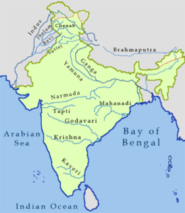
Picture Courtesy – https://in.pinterest.com/pin/87609155236646009/
(A) Himalayan Rivers
Indus System
This system includes the Indus and its tributaries, like Jhelum, Chenab, Ravi, Beas, Sultej(The Panchnad), etc. It is 2880 km long, originates from Mansarovar lake in Tibet. In India, it flows between Zaskar and Ladakh ranges. It is also one of the largest river of the world. It is also known as the Sindhu and is India’s westernmost Himalayan river. It flows from a glacier near Bokhar Chu in the Kailash Mountain range of Tibet. In Tibet, it is known as ‘Singi Khamban’; or Lion’s mouth.
Important tributaries of Indus System:
- Jhelum – It originates from Verinag stream in J&K at 4900 m height & flows only in J&K. It passes through Wular Lake in Kashmir valley. It joins Chenab at Trimmu (Pakistan). Kishan Ganga and Lidar are important tributaries of Jhelum. Controversial Tulbul Project is located on this river.
- Chenab – It originates from Chandra-Bhaga stream in Himachal Pradesh near Lahul & Spiti. It flows in Himachal Pradesh and J&K Jhelum and Ravi meet with Chenab in Himachal Pradesh. Controversial Baglihar Project is located across this river in Doda district of J&K. Salal, Dulhasti and Ranvir Sagar hydropower project is also located on river Chenab.
- Ravi – It originates from Kullu hills near Rohtang pass (Himachal Pradesh). It flows in Himachal Pradesh, J&K and Punjab. Ranjit Sagar (also known as Thein Dam) is located on river Ravi.
- Beas – It originates from Beas kund near Rohtang pass in Himachal Pradesh and flows in Himachal Pradesh & Punjab. It joins Satluj at Harike (Punjab). Indira Gandhi Canal takes off from Harike barrage, which is the longest irrigation canal of India. It runs up to Jaisalmer district of Rajasthan. Pong reservoir is constructed across this river.
- Satluj – It originates from Rakshastal near Mansarovar Lake in Tibet and enters into India through Shipki-la pass (Himachal Pradesh). River Spiti is its major tributary. Satluj flows in Himachal Pradesh and Punjab. It forms boundary between India and Pakistan near Ferozepur. Famous Bhakra-Nangal Projects located on the river Bhakra dam is also called Govind Sagar dam. Nathpa-Jhakri (Himachal Pradesh) is also located on this river and producing more power as compared to Bhakra-Nangal. Satluj is known as Langchen Khambab in Tibet.
Ganga System
Ganga System Ganga is the longest river of India (2510 km). It originates as Bhagirathi from Gangotri glacier in Uttarkashi district of Uttarakhand. Bhagirathi is joined by Alaknanda (originates from Badrinath) at Devprayag. Alaknanda and Bhagirathi flow in the name of Ganga below Devprayag. Major part of Ganga lies in Uttar Pradesh region Famous Tehri Dam is located on river Bhagirathi and it is considered as India’s highest dam (265 m).
Important tributaries of Ganga System:
Left Bank Tributaries –
- Ramganga: It originates near Nainital and joins Ganga near Farrukhabad (Uttar Pradesh)
- Gomti: It originates near Pilibhit and joins Ganga downstream to Varanasi near Ghazipur (Uttar Pradesh).
- Kali or Sarda: It joins Ghaghra which meets Ganga near Chhapra (Bihar).
- Gandak: It originates from Nepal-China border in Tibet and joins Ganga near Hajipur (Bihar).
- Kosi: It originates from Nepal-China border and is also known as Sorrow of Bihar.
- Mahananda: it originates from Nepal – Sikkim border and joins Ganga in Bangladesh.
Right Bank Tributaries –
- Yamuna: It originates from Yamunotri glacier and joins Ganga at Prayagraj. Important tributaries of Yamuna are Chambal (originates from Mhow in Madhya Pradesh), Ken, Betwa, Dhasan etc.
- Son – It originates from Amarkantak plateau and flows towards north and joins Ganga near Manner (Danapur Bihar) upstream of Patna. It is the only peninsular river which directly joins Ganga Rihand river is its main tributary, Govind Vallabh Pant Sagar is located on Rihand river. It lies in Renukot region (near Hindalco) of Uttar Pradesh.
Brahmaputra System
It originates from Tumcho Khambhat glacier in Mansarovar Lake of Tibet. It is known as Tsangpo in Tibet( meaning “purifier”), Brahmaputra in Assam and Jamuna in Bangladesh.
Brahmaputra is volume wise largest river of India where as lengthwise Ganga is the longest river of India. It is one of the longest rivers of the world and with regard to the volume of water it is among the four largest rivers of the world Its drainage system is spread in three countries- China (Tibet), India and Bangladesh and it takes a sharp south-westerly turn along the eastern side of the Namcha Barwa Mountain and forms a 5500 m deep gorge.
Brahmaputra forms largest number of fresh water riverine islands in the world and among this, Majuli is the largest fresh water riverine island in the world.
Important tributaries of Brahmaputra are Subansir Lohit. Tista, Pagladia, Puthumari, Jia Bhore Dibang or Sikang. Koppali, Jal-dhaka, Tor Barak, etc. Last four of these join in Bangladesh.
(B) Peninsular Rivers
The peninsular rivers are distinguished by their fixed course, lack of meanders, and nonperennial flow of water.
The drainage system is older than the Himalayan drainage system.
The Western Ghats, which run near the western coast, serve as a water divide between the major Peninsular rivers.
Except for the Narmada and Tapi, the majority of the Peninsular rivers flow from west to east.
The Peninsular drainage’s other major river systems are the Mahanadi, Godavari, Krishna, and Kaveri.
Narmada River –
- It is the peninsular region’s largest west-flowing river, flowing through a rift valley between the Vindhya (north) and Satpura Ranges (south). It rises in Madhya Pradesh from the Maikala range near Amarkantak. Major Tributaries of the river are Hiran, Orsang, Barna and Kolar.
- The Narmada basin includes Madhya Pradesh, Maharashtra, and Gujarat. The Sardar Sarovar Project has been constructed on this river.
Tapi –
- The Betul district of Madhya Pradesh, which is located in the Satpura ranges, is the source of another significant river that flows west.
- While much shorter in length than the Narmada, it too flows in a rift valley.
- Parts of Gujarat, Maharashtra, and Madhya Pradesh are included in its basin.
Mahanadi –
- The river origins in Chhattisgarh’s Raipur area and flows through Odisha eventually discharging into the Bay of Bengal.
- This river’s drainage basin spans 53% of Madhya Pradesh and Chhattisgarh and 47% of Odisha.
- Seonath, Hasdeo, Mand, Ib, Jonking, and Tel rivers are among the major tributaries.
- Its basin is bordered on the north by the Central India hills, on the south and east by the Eastern Ghats, and on the west by the Maikala range.
Godavari –
- It is also known as the “Dakshin Ganga” and is the largest Peninsular river system.
- It rises in the Maharashtra district of Nasik and empties into the Bay of Bengal.
- Its tributaries drain Maharashtra, Madhya Pradesh, Chhattisgarh, Odisha, and Andhra Pradesh.
- Its main tributaries are the Penganga, Indravati, Pranhita, and Manjra.
Krishna –
- Krishna river is the second largest east-flowing Peninsular river, rising in Sahyadri near Mahabaleshwar.
- Its major tributaries include the Koyna, Tungbhadra, and Bhima rivers.
- Before entering the Bay of Bengal, it flows through the states of Maharashtra, Karnataka, Telangana, and Andhra Pradesh.
Kaveri –
- The Kaveri river rises in the Brahmagiri hills of Karnataka’s Kodagu district.
- It is a holy river in southern India.
- Its major tributaries include the Arkavathi, Hemavathi, Bhavani, Kabini, and Amravati.
- It flows southeast through Karnataka, Kerala, and Tamil Nadu before draining into the Bay of Bengal via Pondicherry.
What are Agro-Climatic Regions of India?
Geographers use the term “area” to refer to any particular portion of Earth’s surface. It may be as small as a park or a neighborhood, or as large as a continent or an ocean. Metropolitan areas, for example, help define the borders of large population centers for a census and other official purposes. The metropolitan area of Delhi, Mumbai are urban geographic areas. Area is also an exact measure of the size of a surface with specific boundaries.

The geographical area of India is divided into 15 agro-climatic regions. These are further divided into more homogeneous 72 sub-zones. The 15 agro-climatic zones are:
- Zone 1 – Western Himalayan Region: Jammu and Kashmir, Uttar Pradesh
- Zone 2 – Eastern Himalayan Region: Assam, Sikkim, West Bengal and all North-Eastern states
- Zone 3 – Lower Gangetic Plains Region: West Bengal
- Zone 4 – Middle Gangetic Plains Region: Uttar Pradesh, Bihar
- Zone 5 – Upper Gangetic Plains Region: Uttar Pradesh
- Zone 6 – Trans-Gangetic Plains Region: Punjab, Haryana, Delhi and Rajasthan
- Zone 7 – Eastern Plateau and Hills Region: Maharashtra, Uttar Pradesh, Orissa and West Bengal
- Zone 8 – Central Plateau and Hills Region: MP, Rajasthan, Uttar Pradesh
- Zone 9 – Western Plateau and Hills Region: Maharashtra, Madhya Pradesh and Rajasthan
- Zone 10 – Southern Plateau and Hills Region: Andhra Pradesh, Karnataka, Tamil Nadu
- Zone 11 – East Coast Plains and Hills Region: Orissa, Andhra Pradesh, Tamil Nadu and Pondicherry
- Zone 12 – West Coast Plains and Ghat Region: Tamil Nadu, Kerala, Goa, Karnataka, Maharashtra
- Zone 13 – Gujarat Plains and Hills Region: Gujarat
- Zone 14 – Western Dry Region: Rajasthan
- Zone 15 – The Islands Region: Andaman and Nicobar, Lakshadweep
| Geographic Areas | Examples |
|---|---|
| Tropical Rainforest | Assam and parts of the Sahyadri Mountain Range |
| Tropical Savannah | Sahyadri Mountain Range and parts of Maharashtra |
| Tropical and subtropical steppe | Parts of Punjab and Gujarat |
| Tropical Desert | Most parts of Rajasthan |
| Moist subtropical with winter | Parts of Punjab, Assam, and Rajasthan |
| Mountain climate | Parts of Jammu and Kashmir, Himachal Pradesh, and Uttaranchal |
| Drought | Rajasthan, Gujarat, and Haryana |
| Tropical semi-arid steppe | Tamil Nadu, Maharashtra, and other parts of South India |

You must be logged in to post a comment.