EduPub (Edupedia Publications Pvt Ltd) is a company dedicated to the development of the education, learning, research and innovation in the field of the research and books publication. We are pioneer in providing wide range of services to educational institutions, government agencies, individuals and corporates in the field of training and education, research and development, research and innovation. research and publication.
Full name of \’A.J. Cronin\’ was Archibald Joseph Cronin. A.J. Cronin was born on 19 July 1896 in Cardross, Scotland. He was a great physician and a writer from scotland.
A.J. Cronin wrote several novels and short stories. His works are renowned for their memorable characters and powerful portrayal of the injustices in the society. His best-known novel was \’The Citadel\’. A.J. Cronin was passed away on 6 January 1981 at the age of 84.
Full name of \’Salim Ali\’ was Salim Moizuddin Abdul Ali. He was born on 12 November 1896 in Mumbai, India. His father\’s name was Moizuddin and his mother\’s name was Zeenat-un-nissa. His parents died in the very early age of Salim Ali.
Salim Ali was a famous ornithologist and naturalist of India. He is known as the \’Bird Man of India\’ because he was an expert on Indian Birds. He studied the habits and lifestyles of Indian birds all his life. Salim Ali has written books on the birds of India. For his great work he was awarded the Padm Bhushan and Padma Vibhushan by the Government of India.
Salim Ali was passed away on 20 June 1987 at the age of 90.
Apart from the great pleasure the cinema gives us a means of entertainment, it is in many ways an education in itself.
The film companies from time to time produce historical pictures and these pictures are of great assistance to the teacher of history. A couple of hours spent in the company of historical personage, dressed in the proper dress of the period, can teach us far more than we can learn from a whole week\’s reading of a history book.
Some of the educational film companies devote their time to the filming of the habits and customs of animals, insects, fish, germs and many other branches of scientific life. Such pictures are quite interesting and are a great help in the cause of education.
Students like geography more than most adults think. Kids are actually drawn to maps’ visual characters, their quirky variabilities, their puzzle-like natures that hold secret troves of meaning just waiting to be decoded.
For evidence, take a look at these ideas that reveal maps’ complexities:
The problem with most geography instruction is not that maps are boring; it’s that they are largely cordoned off within the confines of social studies classes. Maps, however, are by definition interdisciplinary. They unite physicality with artistry. More specifically, they combine political borders with spatial terrains. They expose slave trade routes across temporal spans. They chart celestial bodies through time and space.
The five animations below take map visualizations a step further by adding movement to standard geography. These interactions uncloak a whole new way for students to examine the world they inhabit. Each of these explainer videos adds an unexpected interdisciplinary twist to traditional maps, making them perfect for a range of lessons.
Geography + Sociology
The video entitled “Animated Map Shows How Religion Spread Around The World” was produced by Alex Kuzoian for Business Insider. It elegantly and efficiently traces the progression of global faiths through their continental migrations. It would make an effective companion to a range of sociology, anthropology, history, and religion lessons.
This mesmerizing visualization by NATS (formerly National Air Traffic Services) is called “London 24.” It sketches the number of airplane flights over London each day. The animation is being used in the debate over expanding UK runways, to handle the 3,000 daily flights to these five metropolitan airports. It is a nifty representation of how technology, science, and global wealth have created unexpected issues for modern safety.
Geography + History
This motion graphic from Vox, entitled “220 Years Of U.S. Population Changes In One Map,” explains why the mean center of population is one of the most important and the most understudied metrics of U.S. density. The video offers unique insights into the growth of the American frontier, the expansion of states, and the effect air conditioning has had on the South’s emergence as a population powerhouse.
Geography + Science
“What The Earth Would Look Like If All The Ice Melted,” from Business Insider, offers a compelling case for amping up the awareness of global climate change. Behind oddly disarming music, the animation moves its lens around the world, laying bare which major cities would be flooded if the earth’s temperature continues to rise.
Geography + Geology
Due to cartographic distortions, many people misjudge the size of the world’s landforms. This clip, also from Business Insider, is called “9 Animated Maps That Will Change The Way You See The World.” With jaunty music and cartoon graphics, the video gives a side-by-side slideshow of how the globe’s countries really stack up.
Students like geography more than most adults think. Kids are actually drawn to maps’ visual characters, their quirky variabilities, their puzzle-like natures that hold secret troves of meaning just waiting to be decoded.
For evidence, take a look at these ideas that reveal maps’ complexities:
The problem with most geography instruction is not that maps are boring; it’s that they are largely cordoned off within the confines of social studies classes. Maps, however, are by definition interdisciplinary. They unite physicality with artistry. More specifically, they combine political borders with spatial terrains. They expose slave trade routes across temporal spans. They chart celestial bodies through time and space.
The five animations below take map visualizations a step further by adding movement to standard geography. These interactions uncloak a whole new way for students to examine the world they inhabit. Each of these explainer videos adds an unexpected interdisciplinary twist to traditional maps, making them perfect for a range of lessons.
Geography + Sociology
The video entitled “Animated Map Shows How Religion Spread Around The World” was produced by Alex Kuzoian for Business Insider. It elegantly and efficiently traces the progression of global faiths through their continental migrations. It would make an effective companion to a range of sociology, anthropology, history, and religion lessons.
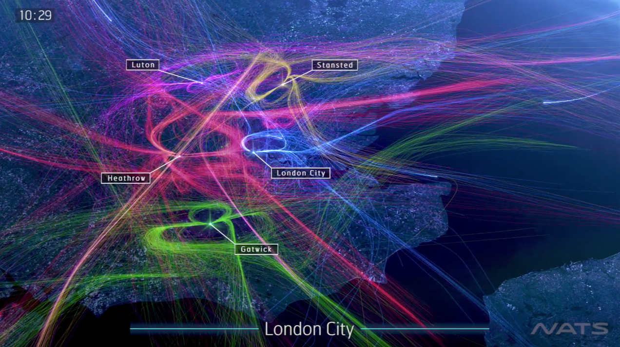
This mesmerizing visualization by NATS (formerly National Air Traffic Services) is called “London 24.” It sketches the number of airplane flights over London each day. The animation is being used in the debate over expanding UK runways, to handle the 3,000 daily flights to these five metropolitan airports. It is a nifty representation of how technology, science, and global wealth have created unexpected issues for modern safety.
Geography + History
This motion graphic from Vox, entitled “220 Years Of U.S. Population Changes In One Map,” explains why the mean center of population is one of the most important and the most understudied metrics of U.S. density. The video offers unique insights into the growth of the American frontier, the expansion of states, and the effect air conditioning has had on the South’s emergence as a population powerhouse.
Geography + Science
“What The Earth Would Look Like If All The Ice Melted,” from Business Insider, offers a compelling case for amping up the awareness of global climate change. Behind oddly disarming music, the animation moves its lens around the world, laying bare which major cities would be flooded if the earth’s temperature continues to rise.
Geography + Geology
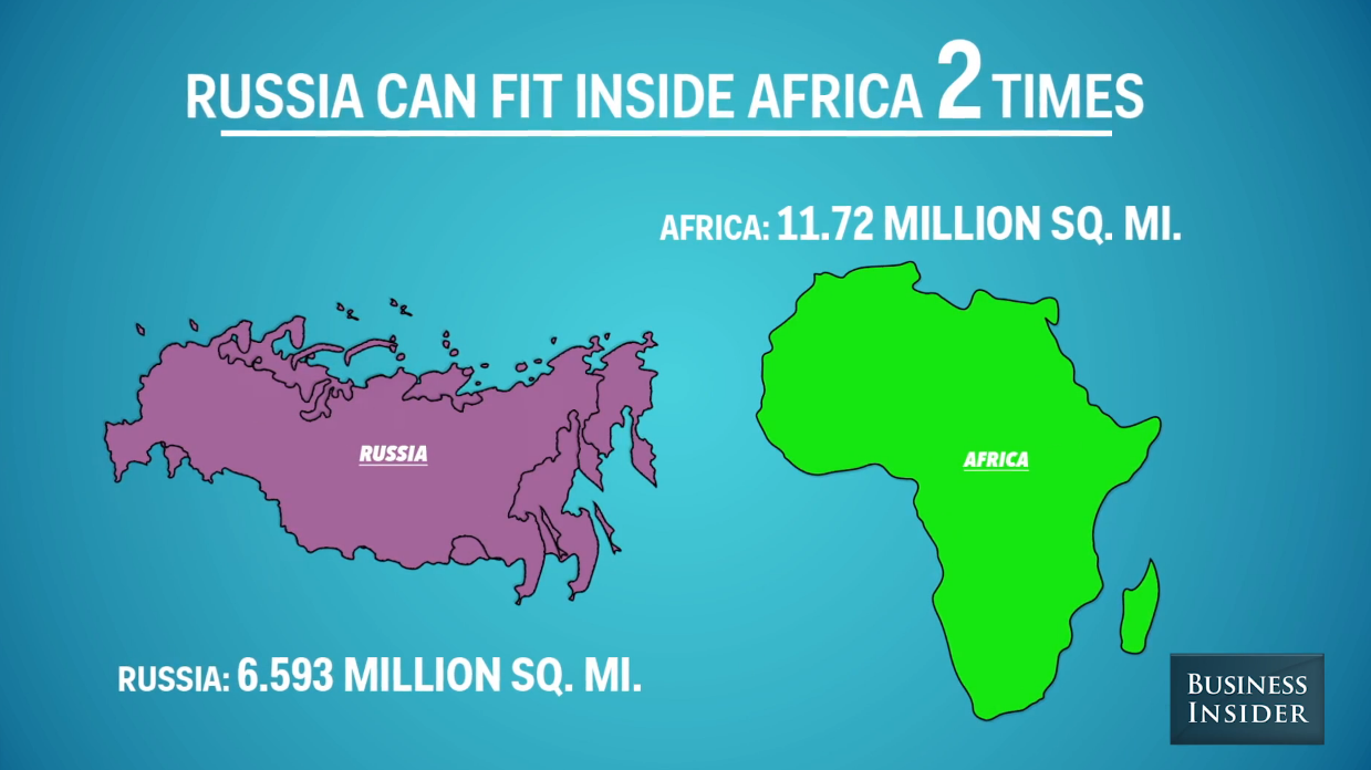
Due to cartographic distortions, many people misjudge the size of the world’s landforms. This clip, also from Business Insider, is called “9 Animated Maps That Will Change The Way You See The World.” With jaunty music and cartoon graphics, the video gives a side-by-side slideshow of how the globe’s countries really stack up.
\’Newspaper\’, as we know, is an essential part of our life. For a newspaper reader, it is the first and foremost thing that he would like to have early in the morning. It connects us with every field and every part of the world. Be it politics, entertainment, sports, films etc.
Newspaper provides information about the burning topics from all over world and keeps us well informed. Though news is also displayed on television and radio, there we don\’t have an option to choose. It results in wastage of time, as the news is repeated over and over again and is followed by a number of advertisements.
Apart from the information newspaper provides, it can be useful in a number of ways. The puzzles given in it develop the thinking ability. The job vacancies column help the people. A regular reader can improve his knowledge of language in which language he reads the newspaper. Newspaper also tells us about the different policies introduced by the Government and makes us aware about everything happening around us.
We can conclude by saying that the newspaper broadens our outlook and is an enormous source of information. Therefore one must develop the habit of reading newspaper everyday.
On August 25, 2016, the National Park Service (NPS) turns 100. After a century of shepherding America\’s splendor, the Park Service and its personnel will rightfully be feted as dedicated, humble stewards of our country\’s most precious landscapes.
Personally, we have been lucky enough to visit many of the nation\’s 59 parks on all points of the compass. Each site has never failed to live up to its consecration as a place of American rarity, pride, and beauty. From the unspoiled trails to the popular overlooks, every curated destination within the wilderness is a testament to the work and vision of the Parks Service.
This august anniversary introduces many opportunities to weave the Parks into authentic classroom lessons. For example, the \”Every Kid In A Park\” initiative seeks to connect our nation\’s youth to its most treasured spaces. Additionally, a wide range of visualizations now provide easy ways to incorporate the centennial into state standards and skill-based curricula. At their least, these videos and graphics offer terrific kick-offs to a morning\’s discussion. At their best, these charts and illustrations support critical student proficiencies. They also bring to life the gorgeous panoply of natural wonder that would make any Disney confection blush.
To start, the \”Find Your Park\” website gathers videos and social media interactions of everyday first-person testimonials about the grandeur of America\’s vistas. As a companion, the NPS has opened its Geographic Information Systems (GIS) data to the public, for educators and graphic artists to tap in building models of terrains and visitations.
Some of the best renderings of the National Parks come from the Works Project Administration during the 1930s New Deal. These art deco posters from the Federal Arts Project capture the majesty of the otherworldly settings in colorful and appealing travel enticements. National Geographic has assembled a nice collection of these posters from the Library Of Congress.
In a video homage, the outdoor outfitter O.A.R.S. has put together a stunning tribute to the Parks, told through the stirring words of Theodore Roosevelt. As befitting its founder, the NPS takes seriously its safeguarding of America\’s geology. It invites students of energy, minerals, and paleontology to explore the singular contours and cliffs through open online access and badging of restoration and geoscience. These resources are terrific for earth science and environmentally minded teachers to investigate with their students.
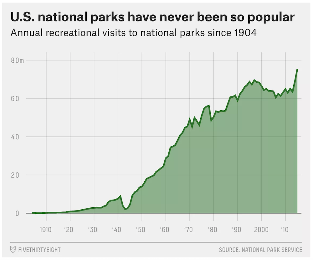
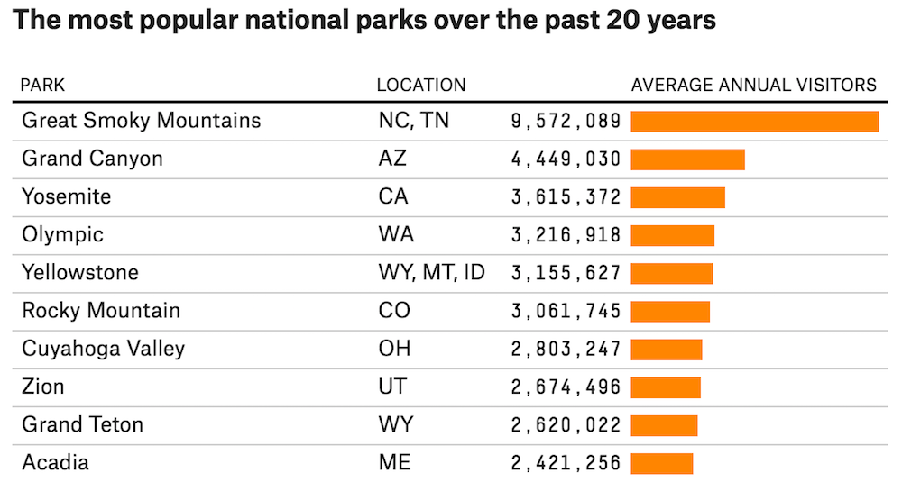
In math and statistics, the minds at FiveThirtyEight (who usually spend their time worrying about political polls and baseball ERAs) have analyzed the popularity of each park. They crafted crisp graphs and charts for STEM educators to draw from in ranking the visitors to each venerated location. As they note, \”the U.S. national parks have never been so popular,\” and the Great Smoky Mountains continues its reign as the most-visited National Park, due to its location and exquisiteness.
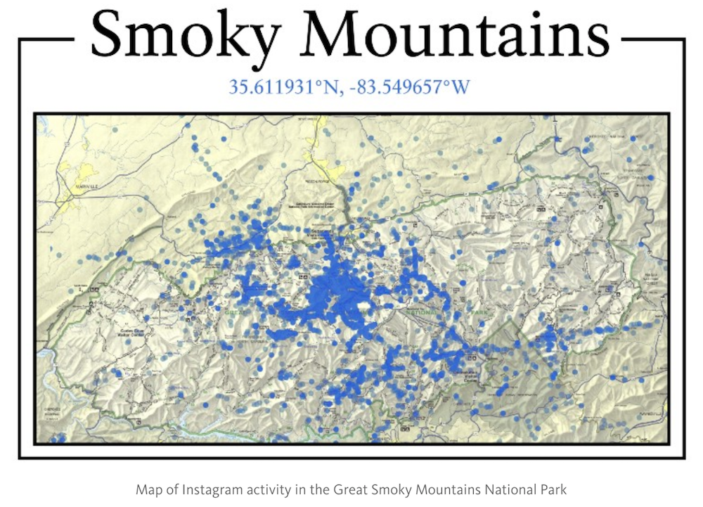
In probing the specifics beneath the Great Smoky Mountains\’ charm, researcher John Farrell raked the Instagram API to determine where in the Park photographs were most frequently snapped. His visualization layers social media atop traditional coordinate geography to present a new picture of the Park\’s usage. He includes similar map mash-ups for other coast-to-coast sites.
For its part, the NPS has put together its own retro advertisement, in the classic style of antique movie reels or 1950s television ads. This wry film is a perfect nod to the 100-year heritage of the organization. It also displays a warm embrace of every citizen who passes through the Parks\’ gates.
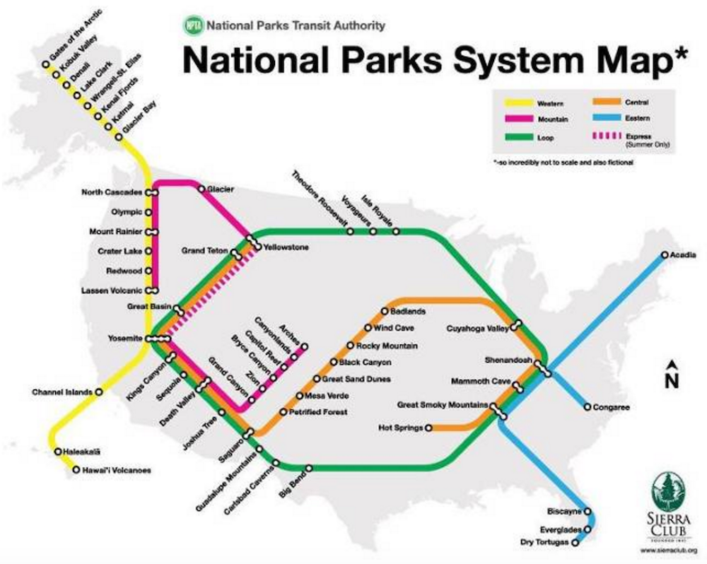
In order to help navigate the Parks, the Sierra Club has designed a System Map based on the urban subway template. This seemingly humorous rendering actually gives travelers a valuable guide in planning their vacations and in connecting the dots between regional marvels.
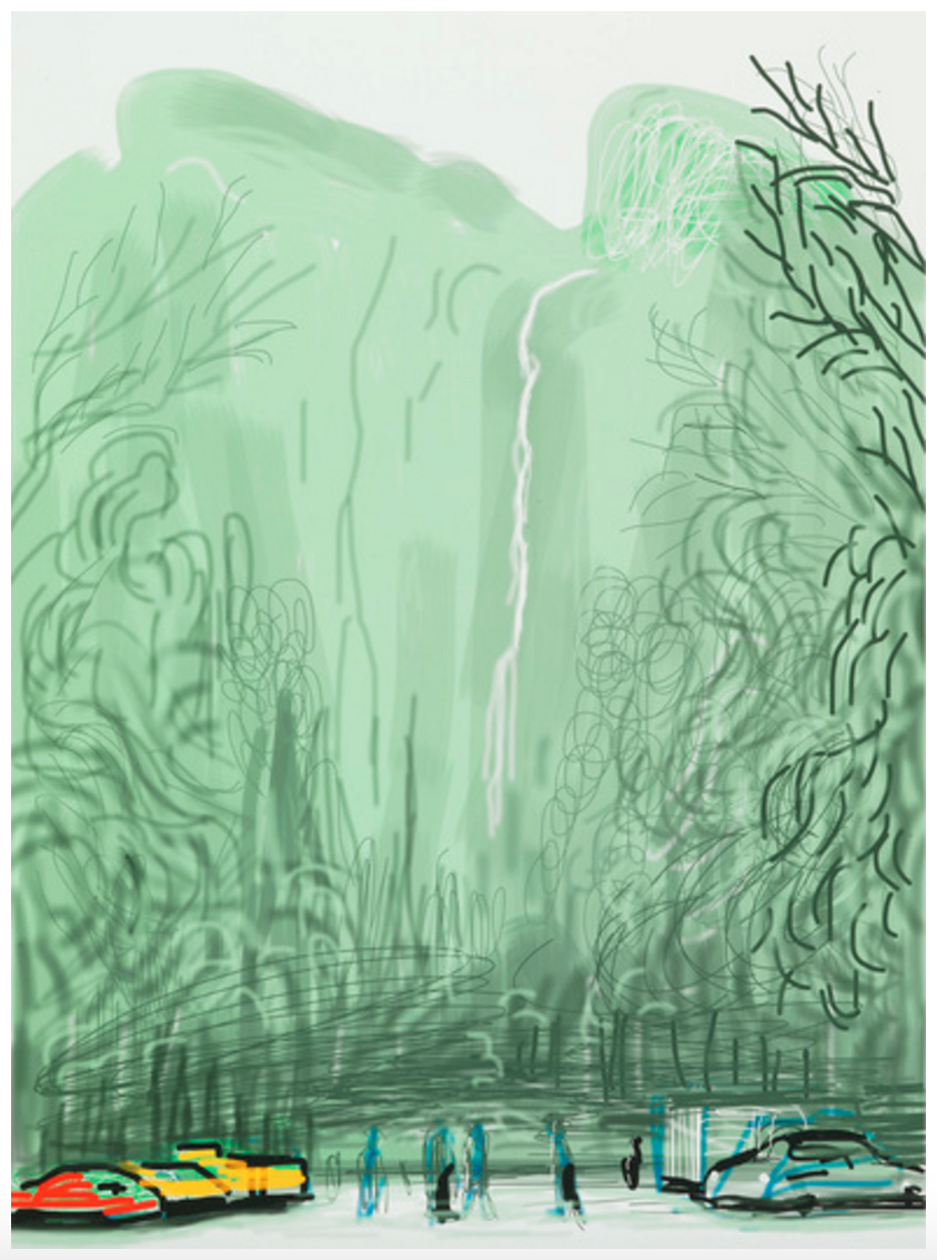
Finally, the purest representations of America\’s National Parks have always come from the minds of the country\’s painters. Beginning with the light portraits of Thomas Moran, many artists have sought to capture the glory of glaciers and geysers. Most recently, David Hockney scratched a series of brilliant sweeps on his iPad in his \”Yosemite Suite.\” These personal, stylized views prove to any viewer that the nation\’s Parks are love letters to its wilderness. They are the last vestige against urbanity and a hallmark of global distinction.


You must be logged in to post a comment.