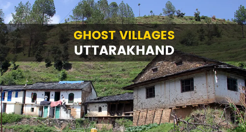
Migration from the hill areas of Uttarakhand is a concerned issue. Many people especially from far-flung rural areas migrate to nearest towns or cities within or outside the state in search of employment and better educational and health facilities. The continuous migration from some villages have resulted in the absolute desertion of those villages with no inhabiting population left behind. These un-inhabited villages are being termed as Ghost Villages.
As per 2011 Census, there are 1048 villages with zero population and another 44 villages have population less than 10 persons.
Browse the list of ghost villages in Uttarakhand by each districts. Pauri district in Garhwal region and Almora district in Kumaon region contain the most number of ghost villages in Uttarakhand.
The film, inspired by Devi’s own life, tells the story of an elderly couple’s love. PITHORAGARH: Hira Devi, 80, is an unlikely film heroine from one of Uttarakhand’s ghost villages, Gadtir, which has several empty houses because of migration. Hira Devi, 80, is an unlikely film heroine from one of Uttarakhand’s ghost villages, Gadtir, which has several empty houses because of migration. The octogenarian, who is illiterate and has lived in the mountain village most of her life, recently got a chance to star in ‘Pyre’, a film inspired by a story similar to her own, which will have its world premiere on Tuesday (Nov 19) at the 28th Tallinn Black Nights International Film Festival in Estonia.
The Himalayan mountain range stretches from Brahmaputra to the Indus River. It ranges over 2500 km and about 250 km thick. So how were these Great Himalayas built?
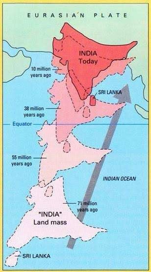
During the late Neoprotozoic era (1000mya-541mya) and early Palaeozoic (541-252mya) , the Indian tectonic plate was a part of the southern Gondwana land .This was separated by the Eurasian plate by the large Tethys ocean . In the early Carboniferous period , an early stage of rifting developed between the Indian subcontinent and the Gondwana land.
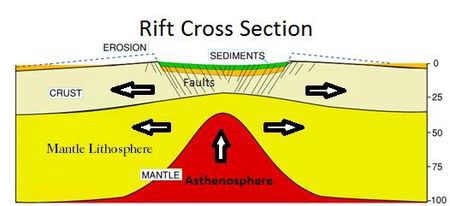
What is a Rift?
A rift is a zone where the lithosphere layer is stretched or pulled apart. In the early stage ,the upper part of the lithosphere starts to extend . As it evolves,some of the fault zones start to connect with each other and become even larger bounding faults .The crust becomes thin causing the rise of Asthenosphere. This way two new tectonic plates are formed from the older single one.
In the Norian period(210 mya), after a major drifting episode the Gondwana land split into two parts. The Indian subcontinent became a part of East Gondwana along with Australia and Antarctica. Later in the early Cretaceous(130 -125 mya), the Indian plate broke off from Australia and Antarctica with the ‘formation’ of Southern Indian Ocean.
At the end of Cretaceous period ,the Indian plate started drifting northward at speeds of about 18 to 20 cm per year which is the highest among all the continental drifts. It covered a distance of more than 6000 km in that time and rotated about 45° counterclockwise relative to the Eurasian plate. Interaction of the Eurasian plate with the coming Indian plate started at about 65 million years ago with the oceanic crust of the latter subducting under the Eurasian plate.
This started the formation of the youngest mountain ranges of the world , The Great Himalayas . This collision was so strong that till present also the Indian plate is colliding northward and the Himalayas continue to rise more than 5 mm a year but due to the stretching of Eurasian plate horizontally and effect of gravity this rising is affected.
Effect on Climate
According to a report of ‘Nature’ magazine, the Himalayan range ormation may have also started Asia’s monsoon about 8 million years ago and contributed to several ice ages that began 2.5 million years ago. The mountain’s and Tibetan Plateau’s uplift gave rise to a dry Central Asia that resulted in the formation of Gobi and Mongolian deserts.
This may have caused a dustier phase in the earth’s atmosphere . The Himalayan range obstructs the passage of cold continental air from north into India in winter and also forces the south westerly monsoon winds to give up most of their moisture before crossing the range northward.
The Himalayas are gigantic and lively and on the other hand they are calm and tranquil, perfect for the soul to grow spiritually.
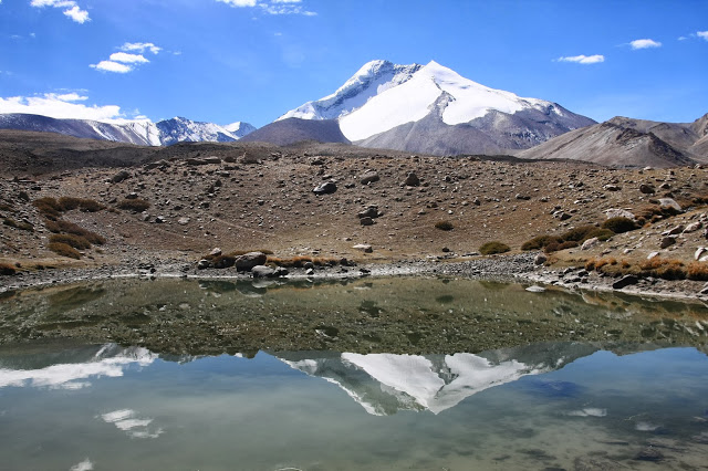
Kang Yatze or Kang Yatse (elevation 6,496 metres (21,312 ft)) is a mountain located at the end of the Markha Valley in the Himalayas in Ladakh. It is located in the Hemis National Park, not long away from the capital Leh.
The mountain has two summits. The true eastern summit is higher at 6,400 m but requires an extremely technical traverse across a knife-edge ridge for the mountaineers wishing to conquer it. The lower western peak (Kang Yatze II) is easier and more frequently climbed, although it is lower at about 6270m.
Kang Yatze II
The lower peak is mainly done from mid-June till September end. There are two approach routes to this peak. One is from Chilling and trekking through the Markha Valley, passing the villages of Skyu, Markha and Hankar. There is another approach that starts from the village of Shang-Sumdo and steeply climbs up the Markha Gorge passing by the campsite of Chyuskirmo, Lartsa and then climbing the Gongmaru La(Pass), a 5130 meter high pass to reach Nimaling. This peak is easier compared to the main lower western peak and does not require any technical mountaineering skills. From the very top, distant peaks of East Karakoram ranges are visible on a clear day.
Kang Yatze I
Kang Yatze I or the Eastern summit requires an intermediate Camp to be set up. The climb to Camp 1 is a short one but over a steep scree and cliffs zone. There is an alternative route following the Glacier where Camp 1 can be set as well. From Camp 1, the climb gets technical. The last 500 meters of the peak is very steep and mandatory fixed ropes.
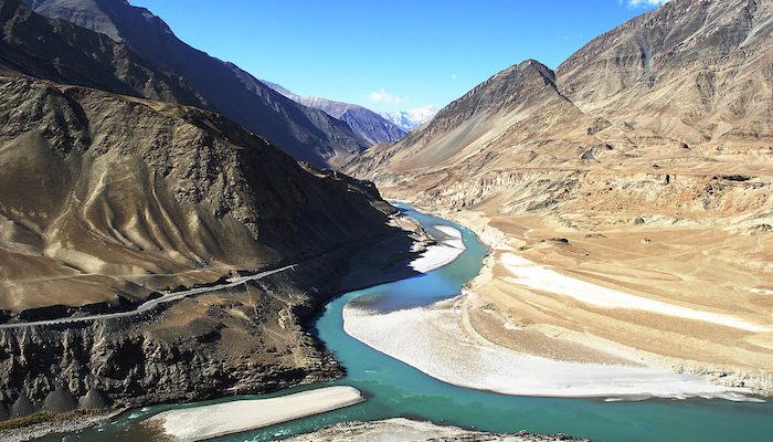
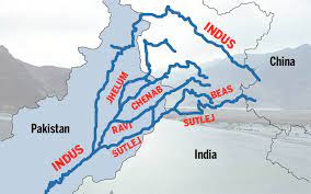
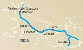
The river Indus as said about the Ganga is a transboundary river that flows Ladakh and Kashmir northwards, passes leftwards towards Nanga Parbat Massif, and Pakistan southwards and ends its journey in the Arabian sea by Karachi. The Indus is termed to be one among the world’s largest rivers in average annual flow, with an estimate of 243 cubic km, which is twice and thrice of the river Nile and the Tigris with the Euphrates combined respectively. The Indus originates from the Tibetan plateau near Lake Manasarovar and enters India in Ladakh. It cuts through the Himalayas in a deep gorge near Nanga Parbat to enter Pakistan. It has five main tributaries – the Sutlej, the Beas, the Ravi, the Chenab and the Jhelum. These rivers give Punjab its name, for the word ‘Punjab’ means ‘five rivers’. This Himalayan river is both snow-fed and rainfed, and therefore flow continuously throughout the year. The river Indus, also known as the Sindhu river, flows for 2897 km, mostly through Pakistan. Since the river moves slowly across the plain, it deposits accumulated silt on its bed. The river bed is thus higher than the sandy plain. When the river is in flood, this results in much destruction. The Indus finally branches into distributaries that join the sea at Karachi. The very river is also famous for the Indus river dolphin, a freshwater dolphin, and one of the world’s rarest mammals. It is, also the second most endangered freshwater river dolphin.
Regions through which the Indus flows
The Indus rises in southern Tibet at a height of about 5500 metres. It flows through a high plateau, then the ground falls away, and the river drops rapidly, and gathers momentum. It rushes northwest and collects the waters from innumerable glacier-fed streams. It flows between the greatest mountain ranges, the Karakoram and the Himalayas. generally, the river becomes slower and has a wider channel as it approaches its delta on the Arabian sea. Agriculture in Pakistan wouldn’t be even possible without this river. In addition, it supplies essential ingredients for human life for many urban areas. These include the Pakistani cities of Islamabad, Lahore, Peshawar and Karachi. Therefore the Sindhu is Pakistan’s longest river with a total length of 3180 km.
The Chenab
The Chenab rises in the upper Himalayas, in the district of Himachal Pradesh in India. Its waters begin from snowmelt from the Bara Lacha Pass. During the Vedic period, it was known as Chandra Bhaga, and it begins at the confluence of two rivers, the Chandra and the Bhaga in Himachal Pradesh. It flows through the Jammu, into the plains of Pakistan. It is first joined by the Jhelum, and then by the Ravi rivers. Later, it meets Sutlej, which has earlier been joined by the Beas.Altogether, these form the so-called ‘five rivers of Punjab’. After, 960 km, it flows into the Indus. The river is dear to the people of Punjab. Moreover, it forms an important part of the land’s history and culture.
Fact: The world’s highest railway bridge – the Chenab bridge – spans the Chenab. It crosses the river in Jammu and Kashmir.
map showing the path of the Indus river
The Jhelum
The Jhelum is the largest, and most western Punjab’s five rivers. It is an ancient river that has been mentioned both by the ancient Greeks as well as ancient Egyptians. It rises from a deep spring, the Verinag Spring in the southeastern part of the valley of Kashmir in India. the river wanders northwards through the valley of Kashmir to the Wular Lake. After emerging from the lake, it continues winding its way through a deep gorge into Punjab. It widens out into an alluvial plain and then goes south to join the Chenab at Trimmu after 813 km. its flow is controlled by snowmelt and the monsoon. In its lower course, the river is famous for its hydroelectric power generation. The Mangla dam and the reservoir on the Jhelum irrigate around 3 million acres of land.
The Ravi
The Ravi, one of the five rivers that create Punjab, crosses national boundaries. It rises in the majestic Himalayas in the state of Himachal Pradesh in India. It crosses Jammu and Kashmir and then flows into Pakistan. After 725 km, it empties itself into the Chenab. It is fed by glacier melt and is the smallest of all rivers of Punjab. In Vedic times, the Ravi was known as Iravati or Airavati river.It is a trans-border river of India and Pakistan. After partition, the river waters were divided between India and Pakistan.
Fact: It irrigates a large area in Punjab through a canal. This canal is known as the upper bari doab canal.
The Beas
The river Beas, one of the five rivers of Punjab, is famous in world history. It is one of the rivers that created problem’s in alexander the great’s conquest of India. His troops mutinied here in 326 BC, refusing to go any further, as they had been away from home for eight years. The Beas rises from the Rohtang Pass in the western Himalayas of Himachal Pradesh and flows south through the Kulu valley. It then enters Punjab and flows in a southerly direction. Thereafter, it finally meets the Sutlej after flowing for 470 km. the chief tributaries of the Beas are bain, Banganga, Luni and Uhal. The river was known in ancient India as the Vipasha, while the ancient Greeks called it the Hyphasis. In the 20th century, it was developed for irrigation and hydroelectric power generation.
The Sutlej
The Sutlej, the longest Punjab’s five rivers, has its source in the Rakshastal lake in Tibet. Sometimes called the red river, it is the easternmost of the Indus river’s tributaries. Further next, it rushes through the Himalayan gorges, and crosses Himachal Pradesh, before entering Punjab. It then joins the Chenab and they empty into the Indus. There are many irrigation projects along its 1400 km long course. They include the Bhakra- Nangal project, and the Sirhind canal. In addition, there is also the Sutlej valley project which benefits both India and Pakistan.
Fact: In the villages of the Sutlej valley you will find descendants of the yak traders of the olden times. These traders were known as Zhang Zhung.
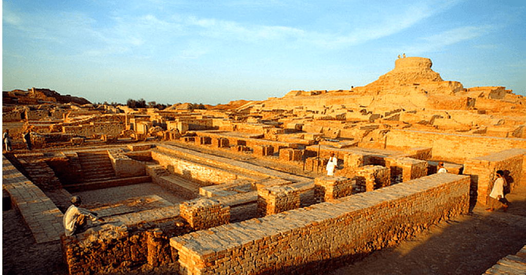
The Indus: the cradle of civilization
One of the greatest civilizations of ancient times flourished on the banks of the river Indus. Around 3300 BC, there were two great cities in the Indus valley, Harappa and Mohenjo Daro. They were very planned and had houses built with bricks, and even a proper drainage system. The town planning, water supply, sewage and drainage system were of very high quality – there were bathhouses and granaries in plenty, too. These cities prove to the world that the most sophisticated urban civilization of its time flourished in India, more than 5000 years ago! The wonders of engineering and architecture, the richness of the culture, and the quality of the life enjoyed by the people all prove that the valley stood to be the cradle of civilization.
The river basin covers an area of around one million square kilometres and extends to four countries. They are China, India, Afghanistan and Pakistan. Snow and glacier meltwater is the main source of water for this river system, as rainfall is low in the region. It ends in a delta, which includes numerous mangroves. The Indus basin stretches to the Karakoram and Haramosh ranges in the north, the Arabian Sea in the south, the Sulaiman and Kirthar ranges in the west, the Himalayas in the east. In India, the basin spreads over the states of Jammu and Kashmir, Himachal Pradesh, Punjab Rajasthan, Haryana and the union territory of Chandigarh.
Indus Water Treaty
India and Pakistan are two of the four countries through which the Indus river flows. The waters of the same and its tributaries support life in vast areas in these two countries. The Indus river system consists of three western tributaries of the Indus and three eastern rivers. The treaty was a result of Pakistani fears that since the sources of the rivers of the Indus basin were in India, India would have total control of the water. So, the world bank drew up a water-sharing treaty called the Indus water treaty. According to this treaty, the Ravi, the Beas and the Sutlej, which constitute the eastern rivers, are allocated for exclusive use by India, before they enter Pakistan. Similarly, Pakistan has exclusive use of the western rivers the Jhelum, the Chenab, and the Indus. The treaty was signed in Karachi on September 19th, 1960.
Major cities in the Indus basin
Industries in the Indus river basin are mainly based on agriculture and allied products. These include the textile, woollen, sugar, oil and paper Industries, as well as Industries manufacturing agricultural equipment. Other Industries in the region are cement, automobiles, machine and machine parts. These Industries have led to the growth of many towns and cities in the river basin. Important urban centres and towns in the basin are Chandigarh, Srinagar, Shimla, Ambala, Bikaner, Bathinda and Patiala. Chandigarh serves as the capital of Punjab and Haryana while Srinagar is the capital of Jammu and Kashmir. Shimla, a beautiful city on the forested hillside of the Himalayas, is the capital of Himachal Pradesh.
Problems faced by Indus rivers
Rapid population growth
As the Indus is one of the longest rivers in Asia, and many civilizations shaped near it, the rapid population growth has a serious hand on the pollution caused. As the number of people around it increases so does the manipulation and excessive use of river water. Thus it could be concluded that the human actions that affect the river pollution counter affect them.
Increased cultivation rate
As the population increases, so does the need for food. Thus for achieving this the cultivations as a whole should be raised to a certain level covering the need. Added to this the Indus basin highly supports cropping. The exploitation caused by chemical fertilizers and pesticides used had serious effects on the river. The
Issues related to reservoir
The inefficiency of the reservoir had been in great discussions among authorities over the years. the increased freshwater need has come to a greater problem. Added to the low capacity of reservoirs, is the issue of inefficient management of the same.
Sewage management
The untreated sewage disposal to the rivers had adversely affected their condition for too long. The urban sewage added to the industrial waste is strengthening the damage caused. Proper treatment of the sewage is the only possible way to counterattack this issue.
Excessive industrialization
The Indus is a cradle of civilization, many industries grew near it, making it a great industrial site from time immemorial. So is the industrial waste disposal to the water bodies. The extensive water manipulation on the industrial need and discharge of the harmful by-products to the rivers marks the need for sustainability over the industrial sector. It is said that it is one of the top rivers that end up polluting the oceans.
Regional climate change
The fast-paced climatic changes such as the overheated summers causing glacier melts in a higher level are the representations of unstable weather conditions. This then leads to a decrease in river water flow. Well, it isn’t a new fact that global warming the main enemy. When fossil fuels are burned which then increases the greenhouse effect leading towards glacier melts. The minute changes in water flow can even cause not so smaller but undesirable changes in crop production and the organisms.
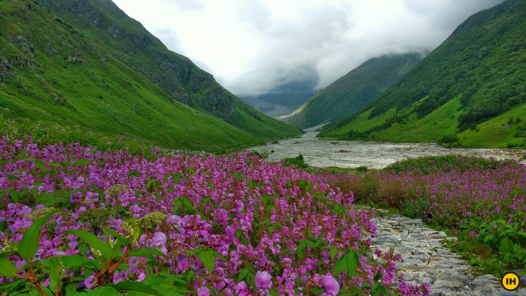
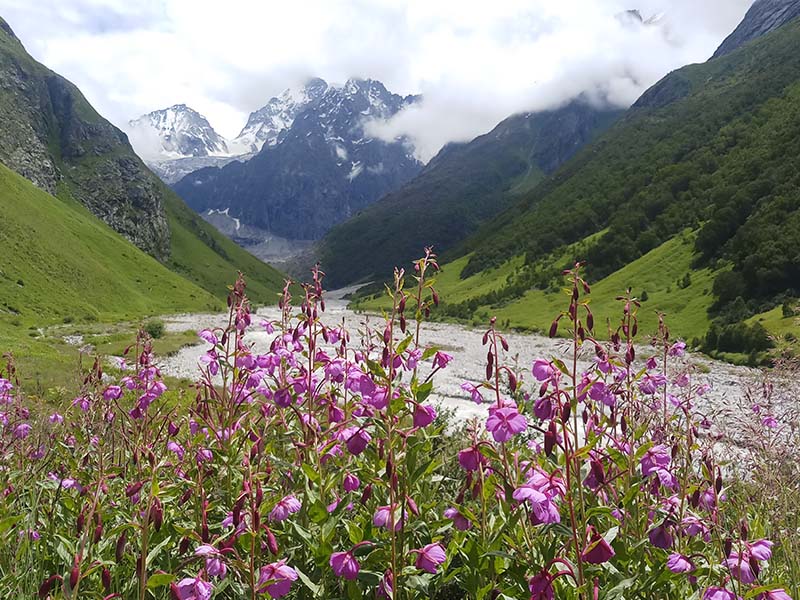
Valley of Flowers is an Indian National Park, located in North Chamoli, in the state of Uttarakhand and is known for its meadows of endemic alpine flowers and the variety of flora. It is a UNESCO world heritage site. This richly diverse area is also home to rare and endangered animals, including the Asiatic Black Bear, Snow Leopard,Musk Deer,Brown Bear,Blue Sheep and Red Fox. The Birds found in the park include Himalayan Monal Pheasant and many other high altitude birds. Valley of Flowers is one of the core zones of the Nanda Devi Biosphere reserve.
Location
The Valley of Flowers is nestled in the upper expanses of Bhyundar Ganga near Joshimath in Garhwal region. To reach the valley one has to reach Joshimath then the nearby Govindghat, trek all the way to a small village named Ghangaria in an approximate 14 km ascent, where there are several trekking routes to the valley. This route is the most popular is followed by many trekking groups. One can also hire a porter, mule or helicopter to reach Ghangaria. The trek from Govindghat to Ghangaria is common to the Sikh Temple at Hemkund and one is likely to find many Sikh pilgrims on the route. The Trek happens during the monsoon season and Ghangaria is closed off for the rest of the year.
Govindghat
Flora
Flowers that carpet the meandering meadows of Valley of Flowers include Orchids, Poppies, Primilas, Marigold, Daisies, Geranium, Petunia, Sediams, Lilies, Calendula, Himalayan Bell Flower, Zinnia and several others. Sub-Alpine forests of birch and rhododendron cover the valley’s area. The park has many species of medicinal plants including Dactylorhiza hatagirea, Picrorhiza kurrooa, Aconitum violaceum, Polygonatum multiflorum and Fritillaria roylei.
Fauna
There are many sub-alpine animals found in the valley. The Red Giant flying Squirrel, Himalayan Black Bear, Red Fox, Himalayan Weasel, Himalayan Goral, Himalayan Musk Deer, Himalayan Tahr and even Snow Leopards are some of the examples of the diversity of the valley’s Fauna.
The three main Himalayan rivers are the Indus, the Ganga and the Brahmaputra. The river Ganga starts from the glacier called Gangothri Glacier, which is in Uttarakhand. At its birthplace, it is known as the Bhagirathi. the Brahmaputra also originates from a glacier, the Angsi glacier in Tibet. Indus originates from the Tibetan plateau near Lake Manasarovar and enters India in Ladakh.
THE GANGA
The mighty Ganga isn’t confined to one country. Its valleys stretch across India and Bangladesh. In fact its basin covers parts of China and Nepal too. Born in the lofty peaks of Himalayas, in the Gangotri glacier, it begins its journey as Bhagirathi. The Bhagirathi rushes down to meet the Mandakini, and then the Alaknanda at Dev Prayag. From then on, the river is known as Ganga. After cutting through the Himalayas, the Ganga breaks out of the foothills at Haridwar, and flows across the vast Gangetic plain. Midway in its course, near Allahabad, it is joined by one of its chief tributaries, the Yamuna river. The Ganga is one of the greatest rivers. The 2525 km long journey finally ends at Bay of Bengal. Thus it is called a river without boundaries.
Tributaries of the Ganga
Rivers have headstreams, tributaries and distributaries. A headstream is a stream that is a source of a river. The Ganga’s headstreams are the Alaknanda, DhauliGanga, Nandakini, Pindar, Mandakini, and Bhagirathi rivers. A tributary is a freshwater stream that joins a larger river. Most large rivers are formed from many tributaries and the Ganga has more than a dozen. Among them are the Ghagara, Yamuna, Koshi, Ramganga, Gomti, Gandaki, Burhi Gandak, Mahananda, Tamsa, Son, Punpun. the Ghaghara is the largest tributary of the river Ganga followed by Yamuna and Koshi. Though Yamuna is a separate river system in itself it is a tributary of the Ganga. A distributary is a branch of rivers that flows away from it. The Hooghly is a distributary of the Ganga that provides water for irrigation for west Bengal. It leaves Ganga just before the river enters the Bangladesh.
Rivers that join the Ganga
The river Ganga actually begins at Dev Prayag, the meeting place of two of its headstreams- the Bhagirathi and Alaknanda. After merging from the mountains of Rishikesh, the Ganga is joined by Ramganga. Later, it joins the Allahabad. The Hindus believe that the mythical river Saraswati too joins here. Hence the name Triveni Sangam, means the meeting place of three rivers. Next the Ganga flows east to meet the river Tamsa, later on, the river Gomti joins it. The next river to join the Ganga is the Ghaghara. Further downstream, the river Son joins the Ganga from the south, the river Koshi from the north. By the time the Ganga reaches the bay of Bengal, its waters have mingled with those of several other rivers, making it mystically representative of a soul of India itself.
Why is the Ganga important to Bangladesh?
The Ganga’s river basin is one of the most fertile and densely populated in the world. It covers an area of1000000 sq.km. For most 150 km, the Ganga forms the boundary between India and Bangladesh. When it enters Bangladesh, it is known as the Padma. The upper Padma flows southeastward to receive the mighty Brahmaputra river. The Brahmaputra is known as the Jamuna river in Bangladesh. The Padma joins the Meghna river, before it empties into the bay of Bengal. The Padma river is known for the frequent erosion of its banks, and sandbars that continually emerge in its course. The river is a busy waterway, and fishing is an important industry along its banks. A number of fast developing urban centres have also come up along its banks.
Yamuna
The river Yamuna is the most famous and greatest tributary of Ganga. One of the country’s most sacred rivers, its birthplace is the Yamunotri glacier, high up in the Himalayas in Uttarakhand. It flows through the foothills of the Himalayas into the Indo-Gangetic plain, flowing through Uttar Pradesh, Himachal Pradesh, Haryana, Rajasthan, Madhya Pradesh and Delhi. After 1376 km, the Yamuna meets the Ganga at Allahabad. Their confluence is well known. The important tributaries of the Yamuna river are Tons, Chambal, Hindon, Betwa and Ken. Other small tributaries of the Yamuna river include the Giri, Sind, Uttangan, Sengar and the rind. Thus, though the Yamuna is a tributary of the Ganga, it has many tributaries of its own as well. Therefore, the Yamuna is considered to be a river system in itself.
Ghaghara
The Ghaghara is the largest tributary of the Ganga. It is a river that crosses many countries in the journey. Born in Himalayas in Tibet, it flows southeast through Nepal. Later it splits into two branches that rejoin south of Indian border. The Ghaghara flows through Uttar Pradesh and Bihar, and then joins the Ganga. Its major tributaries – the Kuvana, the Rapti and the little Gandak rivers – all flow into the Ghaghara from the mountains to the north. The river’s flow is influenced by both the glacial melt and the monsoon together with the Ganges and its tributaries, the Ghaghara has helped to form the vast, fertile, alluvial plain of northern Uttar Pradesh.
Gomti
The river Gomti, a tributary of the Ganga, has great mythological significance. Most Hindus believe that a ritual dip in its waters will purify a person from all sins. According to legend, the river the daughter of sage Vasishta, who brought the river from heaven to earth. The river is also associated with the epic Ramayana. Lord Rama is believed to have taken a dip in the river on the advice of sage Vasishta. Lakshmana, the younger brother of lord Rama, is believed to have Lakshman Teela – part of present day Lucknow on the banks of river Gomti. Some even trace the name of Lucknow city to Lakshmana. The Gomti rises in northern Uttar Pradesh, and flows through the state, draining an area of 18750 sq. km. It is joined by one of its own tributaries before flowing into Ganga.
Gandak
The river Gandak is formed by the union of two rivers that have their own source in the Himalayas in Nepal. These rivers are the Kali and the Trisuli, and once they merge, the river is known as the Narayani in Nepal. The river then flows southwards into India. It is joined at the Indo – Nepalese border by two other rivers from Nepal – the Panchnad and Sohna. Once it enters India, the river is known as the Gandak. After winding its way through 765 km, it merges with the Ganga opposite the Patna. The Gandak is one of the major rivers in Nepal and India. It is distinguished for the deep gorge across which it flows, and for a large hydroelectric facility in Nepal. This river also provides water for a major irrigation and hydroelectric power facility at the Indo Nepal border at Valmikinagar.
Koshi
The Koshi river also called the Kosi – is an important tributary of the Ganga. It flows through Tibet and Nepal, before entering India from the Himalayas. The river is joined by major tributaries, approximately 48 km north of the Indo Nepal border, breaking into more than 12 distinct channels. These channels shift during flooding and so, the river shifts course frequently. The river basin is surrounded by the ridges separating it from the Brahmaputra in the north, the Gandaki in the west, the Mahananda in the east, and by the Ganga in the south. The river, along with its tributaries, drains a total area of 69300 sq.km up to its confluence with the Ganga in India.
Tamsa
The Tamsa river flows through Madhya Pradesh and Uttar Pradesh. A tributary of the Ganga, its origin is at Tamakund in Kaimur range. The Tamsa is 264 km long. It is famous for the many waterfalls through which it tumbles during its journey to meet the Ganga. The river has great significance for Hindus for their belief that lord Rama spent his first night during 14 years of forest exile on the banks of Tamsa. There is also a belief that the rare and elusive Fwindoju fish lives in this river. The ashrams of the sage Valmiki and Bharatwaj are also believed to have been located on the banks of the Tamsa.
Son
The Son, a tributary of the Ganga, is one of the largest rivers in India. It starts near Amarkantak in Madhya Pradesh and has a total length of 784 km. The Son’s main tributaries are the Rihand and the North Koel. It flows through Uttar Pradesh, Jharkhand, and Bihar to join the Ganga just above Patna. When fed by the monsoons, it becomes a roaring force. However, during the summer, it dries up in places, leaving large pools of water along its course. The Indrapuri barrage is located on the Son. It is one of the longest dams of India and it irrigates vast areas of agricultural land.
On 7 February 2021 Uttarakhand’s Chamoli district experienced a disaster in the form of an avalanche when a small portion of the Nanda Devi glacier broke off. The sudden deluge caused considerable damage to NTPC’s Tapovan-Vishnugad hydel project and the Rishi Ganga Hydel Project. At least 72 people were confirmed to have been killed in the disaster. But this is not a new phenomenon and every year there are many reports of sudden deluge all across the Himalayan region.
The Himalayas has maintained the climate of the Indian subcontinent. Himalayas act as a barrier by diverting the monsoons to pour the rain in the fertile northern pains rather than to drift away to further north. Similarly, the mountain range also blocks the cold northern winds to reach the Indian subcontinent. The Himalayas all the way from Afghanistan to Myanmar with 110 peaks over 24,000 feet. They are also very rich in biodiversity and are the source of numerous perennial rivers and water bodies. Rivers like Indus, Ganges, and Brahmaputra that originate in the Himalayas are the lifelines of millions of people in the subcontinent.
But in recent years, the Himalayan region has seen a drastic transformation with increasing population and deforestation. The Himalayas are still a very young mountain range and this means the region is not as stable as older mountain ranges. This is also the reason for the high number of earthquakes. There are many exploitative projects and resource extractions initiatives have are going throughout the region. The increasing influx of tourists in the Ladakh region which is increasing the pressure in the already sensitive region or the limestone extraction near Mussoorie which has transformed the surrounding lush mountain region barren and unstable are just some of the instances. The cities located in the periphery of the Himalayas have started are also facing the same degradation problems in the plain region. Due to ever-increasing population growth, the size of cities is also increasing and this means overflowing garbage and drains. Unplanned growth of new settlements and uncontrolled tourism has only exacerbated this issue.
There is a need for safeguards on a national level that would help in preserving the fragile ecology of this region. First, it needs to be ensured that there is sustainable urbanization in the mountain habitats by town planning and adoption of architectural norms. Due to the sensitivity in this region, it is imperative that we have to control the growth of new settlements in the region and the existing settlements should be developed with all the basic urban facilities. Solid waste management is another area that needs to be the focus. Plastic bags use should be banned in all the towns and villages in the Himalayan region. Some states like Himachal Pradesh and Sikkim have enforced this rule but there are still many other states that have not fully implemented this rule. Pilgrimage is an important part of the tourism sector in the Himalayan region. Sustainable pilgrimage needs to be promoted and the inflow of pilgrims has to be determined according to the ecological capacity of that site. Roads are an essential node for the connectivity and development of a region but the construction of the roads and highways needs to take into account the sensitivity and fragility of the region as well. Environmental impact assessment should be compulsory before the construction of roads. Finally, environmental awareness needs to be propagated so that every individual can be empathetic and mindful of the dangers of environmental degradation. A coordinated effort will be essential between local cultures, local people, unions, and state governments to make this happen.


You must be logged in to post a comment.