Discover Cities is a fully open access, peer-reviewed journal that supports multidisciplinary research and policy developments across the field of urban science. The journal aims to be a resource for researchers, policy makers and the general public for recent advances in urban research, and the range of interdisciplinary studies that focus on cities and urban life. As a fully open access journal, we ensure that our research is highly discoverable and instantly available globally to everyone. The journal particularly welcomes work that aims to address the United Nations Sustainable Development Goals, especially Sustainable Cities and Communities; Industry, Innovation and Infrastructure; and Responsible Consumption and Production.
Topics
Topics welcomed at Discover Cities include but are not limited to the following:
Smart Cities:
Big data processing and analytics
Machine learning, and artificial intelligence applications
Mobile and wireless sensor networks; location-based services
Internet of Things (IoT); 5G and satellite-based communications
Cloud and edge computing; smart city governance
Digital twin of urban areas and systems
Urban Energy and Sustainability:
Renewable energy sources; energy consumption and carbon emissions
Smart grids and energy management; urban heat island mitigation
Energy transition and decentralization
Energy storage; water-energy nexus; energy communities; zero-energy building (nZEB)
Urban Planning, Design and Transport:
Urban design, development, regeneration and revitalization
Public transportation; pedestrian infrastructure; cycling infrastructure; shared mobility services
Urban public transportation and traffic management
Urban Constructions:
Assessment and retrofitting of existing constructions
Sustainable constructions
Innovative construction materials and techniques
Lifecycle assessment of buildings and building stocks
Urban Climate and Impacts:
Impact of climate on safety and life quality in cities
Extreme climatic events and effects
Effects of climate changes on the urban environment; adaption and mitigation
Built Environment:
Green architecture and building design; urban infrastructure;
Indoor environment
Building information modeling (BIM)
Urban Water:
Urban water infrastructure and management
Urban drainage; urban catchment hydrology and modeling
Urban water storage and contamination
Urban wastewater collection, treatment and recycling
Urban Agriculture and Forestry:
Urban farming; community gardens; rooftop farms
Vertical farming
Planting, maintaining, protecting of urban trees
Urban Economics & Policy:
Urban infrastructure investment and financing; Incentives for renewable energy adoption; energy-efficient building codes; urban housing markets and affordability
Urban poverty, inequality, and social welfare policy
Urban tourism
Urban Health and Well-being:
Healthcare services and facilities in urban areas
Urban health disparities and inequities
Urban environment and its effects on public health
Content types Discover Cities welcomes a variety of article types – please see our submission guidelines for details. The journal also publishes guest-edited Topical Collections of relevance to all aspects of urban science. For more information, please follow up with our journal publishing contact.
The Street Space Index (SSI) is a concept used primarily in urban planning and transportation studies. It is a measure that assesses the efficiency, accessibility, and utilization of street spaces in cities. The index evaluates how well the street environment accommodates different functions like walking, cycling, driving, and public transport. The goal is to help cities improve the design and use of their streets for more sustainable and livable urban spaces.
Multimodal Transport Integration: The SSI often takes into account various transportation modes—cars, buses, bicycles, pedestrians, etc.—and measures how well these modes coexist and are prioritized in the street design.
Space Allocation: It looks at how much space is dedicated to each mode of transportation and public space (e.g., sidewalks, bike lanes, lanes for cars, parking spots). A high-quality street space prioritizes pedestrians and cyclists over cars, enhancing safety and reducing congestion.
Accessibility and Connectivity: It considers how easily people can access public transport, walkways, or bike paths, and how well-connected the street is to other key areas of the city.
Public Space and Amenities: The SSI may also evaluate the presence of public amenities such as benches, trees, lighting, and street furniture that contribute to the street’s overall livability.
Environmental Impact: The environmental sustainability of street space is also a consideration. This includes assessing factors like green spaces, water drainage, and the presence of nature, as well as the promotion of low-carbon transport options.
Purpose of the Street Space Index:
Urban Planning: The SSI helps city planners identify areas where streets are underutilized or poorly designed. This information can guide interventions to make streets more efficient and inclusive for all users.
Sustainability: It aids in designing streets that promote sustainable transport modes like cycling or public transport and reduce dependency on private cars.
Quality of Life: By improving the design and functionality of street spaces, cities can enhance residents’ overall quality of life, making neighborhoods more pedestrian-friendly and less car-dominated.
In essence, the Street Space Index provides a quantitative and qualitative evaluation of how streets function and how they could be improved to meet the needs of urban communities.
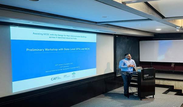
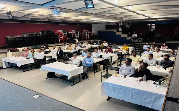
The National Industrial Corridor Development Corporation Limited (NICDC), under the administrative control of the Department for Promotion of Industry and Internal Trade (DPIIT), Ministry of Commerce and Industry, Government of India, in collaboration with the CEPT Advisory Foundation (CAF) of the Centre for Environmental Planning and Technology (CEPT) University, organised a workshop to discuss the sustainable design of administrative buildings for 12 new greenfield industrial smart cities recently approved by the Government of India. This first-of-its-kind workshop, held on October 24, 2024, at the CEPT University campus in Ahmedabad, Gujarat, focused on highlighting sustainable design concepts such as biophilic architecture, integrated and inclusive planning, energy efficiency, and climatic bio-massing.
It has been envisioned that administrative buildings in these futuristic smart cities will embody these advanced principles to create uniquely designed structures that contribute to eco-friendly urban landscapes.The workshop was held to inspire Special Purpose Vehicles (SPVs) and state officials to participate in discussions on emerging technologies and sustainable practices on both national and global levels.
Participants engaged in two detailed sessions during the workshop. In the initial session, the emphasis was placed on the value of good design and its role in creating appealing, functional workspaces. Distinguished architects demonstrated exemplary projects to showcase the advantages of innovative designs, while open discussions were held on the latest design trends and implementation challenges. This session was led by renowned professionals, including Ms. Aparna Khemani from Gensler, Mr. Bedanta Saikia from Edifice, and Mr. Ambrish Arora from Studio Lotus.
In the second part of the workshop, the CAF team outlined a robust and transparent process for procuring architectural services. This presentation emphasized the importance of balancing quality and cost in commissioning competent designers through a reliable and thorough process. This session was facilitated by Mr. Prasad Jasti from Jacobs and Mr. Avanish Pendarkar, Center Head, CEPT Urban Planning and Design Foundation – CoE.
CEO and MD, NICDC, Shri Rajat Kumar Saini, IAS, stressed the significance of developing unique, iconic administrative buildings in the industrial smart cities being established under the National Industrial Corridor Development Programme. The aim of these industrial corridors is to create dynamic zones that stimulate industrial growth, improve logistics, and foster eco-friendly environments. Shri Saini expressed the NICDC’s vision of collaborating with CEPT University and CAF to develop resilient cities equipped to meet the needs of future generations.
CAF Director, Mr. Darshan Parikh, highlighted the importance of this collaboration with NICDC and SPVs, emphasising that CAF is committed to supporting NICDC in realising the vision of iconic buildings across designated locations. Mr. Parikh added, “Together, we aim to work collaboratively to bring the best design competencies for the development of these iconic administrative buildings”.
The workshop concluded with state officials gaining a deeper understanding of the nuances involved in designing and planning context-specific, innovative administrative buildings. This initiative represents a step toward the goal of Viksit Bharat, showcasing the pivotal role that architecture, culture, design, planning, technology, research play in building a robust and sustainable future.
NICDC, formerly known as the Delhi Mumbai Industrial Corridor Development Corporation, is responsible for developing greenfield industrial smart cities with manufacturing as the primary economic driver, as part of the National Industrial Corridor Development Programme.
CEPT Advisory Foundation (CAF) is a section 8 (non-profit) company that focuses on advisory projects, constituted in November 2023. CAF offers services across nine thematic centres, including urban planning, transport, infrastructure, and water supply and sanitation. Its portfolio includes over 200 projects, ranging from development and strategic plans to feasibility studies and development control regulations.
As an urban planner, you know the importance of legibility and comprehensibility in communicating plans for the built environment. Developing an understanding of the tools and techniques of urban design is a crucial benefit to the implementation of effective plans.
Urban Planners are often required use urban planning software which bridges the various disciplines involved in city planning. While not always the case, the softwares and tools used within the urban planning can be quite expensive. Especially when you are self employed. Fortunately, there are free urban planning software alternatives available, which does well in completing the necessary tasks. However, unfortunately some of the paid software do not have alternative free and open source software.
We have attempted to summarise the key urban planning software and tools used today, both free and paid. This list has been made in an effort to make it easy to understand the software that exists and is used today. Although, the list is currently not fully comprehensive it gives an overview. The list will moreover be updated once in a while to reflect software not listed here.
We hope this list is useful and provides some help in finding urban planning software and tools that can support your work. \
Whether you’re a professional in the urban planning field or an urban planning student, learning basic design principles doesn’t require a graphic design degree. Thankfully, there are a number of free software tools available to take your plans to the next level, here are some of the urban planning tools that every planners need to know:
GNU Image Manipulation Program, commonly known as GIMP, is a raster-based image manipulation software. If you’re familiar with Adobe Photoshop, you will find GIMP to be an effective (and free!) alternative with similar capabilities. In the context of urban design, GIMP is used to edit images, add text to images, and overlay graphic content on maps. Additionally, GIMP offers some great free educational resources and tutorials.
SketchUp is an indispensable tool to urban planners and urban designers alike. Unique in its ability to quickly and accurately render 3-dimensional forms, Sketchup provides users with an effective tool to visualize buildings, neighborhoods, and even cities. There are some limitations to the freeware version as opposed to SketchUp Pro, but there are workarounds you can learn in the Urban Design for Planners: Software Tools. What’s more, SketchUp integrates easily with Google Earth (read on to learn more!).
Inkscape is vector-based, open graphic manipulation tool often used as a counterpart to GIMP. For the urban designer, Inkscape is used to draw and manipulate shapes and lines on maps. Comparable to Adobe Illustrator, Inkscape offers a user-friendly alternative for planners and designers.
QGIS is a free, open source Geographic Information System with powerful capabilities. Compatible with Esri (the industry standard maker of ArcGIS), QGIS is perfect for the planner looking to expand their design capabilities. Use QGIS to view multiple layers of mapped data relative to one another, group locations or elements with sets of criteria, determine distance calculations, examine proximities, and quickly create figure ground maps. QGIS makes it simple to quickly get up to speed with the program with an extremely active support community.
Google Earth is a crucial tool that lends itself to a variety of professional applications. Particularly useful to urban planners and urban designers alike is the ability to explore cities from an axonometric view (from the perspective of a low flying plane). Other settings provide the ability to experience a 3D perspective, accurately measure distance, and integrate with GIMP and SketchUp. Beyond these practical aspects, the potential to explore cities and landscapes around the world makes Google Earth a ground-breaking resource.
6. ESRI ArcGIS is the most widely used GIS software in the world. It allows The ArcGIS software have allowed planning agencies to carry out both traditional and previously impossible tasks more efficiently and easier. With the various functions the GIS programs offer, urban planners can create and assess different development scenarios and test the potential impacts they will have on future land use, demographics and employment options. Consequently, ArcGIS has created a spatial tool that provides more informed planning decisions.
7. ArcGIS CityEngine is another 3D modelling software. It is used by urban planners, urban designers and architects to create a large city without the need to model each building separately. The software allows you to measure areas, distances and paths, and compare various development proposals and analyse design solutions.
8. ArcGIS Urban is another ESRI application focused on the urban planning and design professions. The ArcGIS Urban software provides an 3D experience allowing for better understanding of potential land use and development. Thereby decision-making is better formed by visualising and understanding how development projects will fit into the local surroundings.
9. Modelur is a simple and inexpensive SketchUp extension that is somewhat similar to CityEngine. While Modelur is lacking rendering options and extensive functionality as included in CityEngine, it provides a powerful 3D tool to quickly create conceptual urban massing. It calculates your design’s urban planning parameters in realtime, such as Floor Area Ratio (FAR), Gross Floor Area (GFA), Built-up Area (BUA), Site Coverage, recommended parking lots and green area. Therefore you can easily adjust your design to be aligned with the requirements for the site in question. Furthermore, the software tool provides well informed decisions.
Modelur offers free student licenses, but you need to provide proof of university enrollment.
10. Streetmix is an online open source street design tool. It provides a user-friendly and fun way to create fast proposals for street and public space improvements. The tool was created for city planners, public and private companies, pedestrian and bike advocates to make street-making accessible for everyone.
Ministry of Housing and Urban Affairs (MoHUA) announced the opening of Urban Geospatial Data Stories Challenge to foster adoption of geospatial technologies & to promote innovation in India’s urban ecosystem. The challenge has been organized with select Smart Cities that will be publishing high quality GIS datasets.More than 1000 geospatial datasets have been made available to the registered participants from national geospatial agencies, private sector enterprises, scientific and academic institutions, businesses, consumer services & start-ups to analyse this data and create insightful data stories.
Leading up to the ‘Azadi Ka Amrit Mahotsav- Smart Cities: Smart Urbanization’ conference scheduled to be held in Surat, during February 2022, the Urban Geospatial Data Stories Challenge is part of a series of pre-event initiatives being undertaken by MoHUA to foster adoption of geospatial technologies & to promote innovation in India’s urban ecosystem. The challenge will commence for the registered participants on 1st January, 2022 and conclude by end of January 2022.
The Challenge has been designed to promote Geospatial Policy and to make India a Geospatial enabled nation. Sharing and integration of wide range of data will empower citizens and enterprises to create, assess, and use geospatial data and information for empowering people and making urban services and applications more effective. Built on the concept of ‘open innovation’ & ‘open data sharing’, the hackathon is likely to benefit stakeholders across all cities in India. Assimilation of innovative ideas & solutions from a wide array of geo spatial experts covering academia, private sector, emerging technologies, and government would help in solving some of the most common problems faced by the citizens of any city and replicating the successful ideas in other cities.
800 participants have registered till date and more than 10 Agencies have partnered for mentoring and evaluation, making this challenge a collaborative effort towards making India a Geospatial enabled nation. The Challenge details, including datasets and guidelines for participation are available online at https://urbanhack.niua.org/
Azadi Ka Amrit Mahotsav
Azadi Ka Amrit Mahotsav is an initiative of the Government of India to celebrate and commemorate 75 years of progressive India and the glorious history of its people, culture and achievements. This Mahotsav is dedicated to the people of India who have not only been instrumental in bringing India thus far in its evolutionary journey, but also hold within them the power and potential to enable Prime Minister Modi’s vision of activating India 2.0, fuelled by the spirit of Atmanirbhar Bharat.
Azadi ka Amrit Mahotsav is an embodiment of all that is progressive about India’s socio-cultural, political, and economic identity. The official journey of “Azadi ka Amrit Mahotsav” commenced on 12th March 2021 which starts a 75-week countdown to our 75th anniversary of Independence.
“Floating Neighborhood” is a water-based solution for the problem for Holland’s housing needs. This neighborhood floats, freezes, tilts on the water of Lake Eimer. The goal is to “make a circular, resilient, floating neighborhood”. The floating houses have similar architecture to that of the land homes and each house is connected to the floor of Lake Eimer. The building elements of the houses are: wood, plastic and glass. The architecture of the neighborhood is based on water environment and each house have individual water jetties for getting connected with land. Running below the jetties, cables and pipes generate gas, electricity, water, cable, and provide a sewage drainage system for each floating home. The community of the water dwellers have the facility where when one resident is short on electrical power, another neighbor can offer some of theirs if they’ve got any leftover current. The Municipal Authority along with other innovators, planners and architects developed a draft for sustainability master plan for the floating development with maximum priority on sustainability.
Floating House
The main aim of “Floating Neighborhood” is to build sustainable neighborhood capable of addressing the challenges of an aquatic environment and harness the unique synergies it offers to residents. The neighborhood has adopted many approaches for solving environmental issues and rising sea level.
Adopted Approaches:
Sustainability of Floating Neighborhoods
Sustainable Solutions: The neighborhood relies on carbon intensive gas heating, well-insulated homes and passive solar heating through designs which make maximum utilization of natural sunlight, along with pumps which harvest warmth from the canal water even in winter. Solar boilers provide hot water, and water-recycling showers are equipped with technologies that recover heat that would otherwise go down the drain.
Harvesting waste water: The wastewater is transported to a nearby floating biorefinery which recovers nutrients and energy from the organic waste streams. Houses have vacuum toilets which are linked with decentralized sanitation facility and use anaerobic digester for producing energy using biogas, phosphorous and nitrates.
Usage of Sustainable Building Materials: The neighborhood uses sustainable building materials only which are light in weight and buoyant (bamboo is mostly preferred). The neighborhood has a community center which serves as a hub of neighborhood wide sustainability initiatives.
Smart Microgrid on Water: With the help of smart microgrid system on water, the residents have special permission that provides them the ownership of their own grid as well as energy sourcing and billing. Each house as installed large solar PV array and heat which with battery storage systems. The households have connections with energy management system which intelligently coordinates supply and demand of power within the community and allows the residents to trade energy with each other.
Replicable Blueprint for Green Building: The homes have green roofs where the residents can grow foods and plants. They can also collect rainwater and use it for different purposes. The rainwater can also be used for flushing the ultra-efficient toilets. The homes have solar hot water collector which connects to fixtures like recirculating shower, which cleans water in a water loop and saves both water and energy.
“The village is the cell of the national body and the cell-life must be healthy and developed for the national body to be healthy and developed.” – well alluded by SRI AUROBINDO.
India as it is said is the “land of villages.” The heart of our nation resides in the rural areas. As quoted by the father of our nation, Mahatma Gandhi, “India lives in her seven hundred thousand villages.” Although the term “Rural development” has been widely used, what constitutes it seems to have changed significantly. So, the question is what exactly is rural development. Rural development means improving the living conditions of the people living in rural areas. There are many definitions to it. The fact is that today more than half of the Indian population lives in rural areas and most of them depends upon agriculture as their primary source of income. Agriculture is an integral part of many world economies, especially the developing ones, and hence plays a significant role in the rural development. The strength and prosperity of our nation depends upon the strength and prosperity of rural areas. Therefore, it is important to free the rural India from poverty.
Our government is trying its best to bring rapid growth and development in the villages. We derive major contributions to GDP from rural workers. Upwelling schemes for rural electrification, open defecation free villages, skill development, Prime Minister rural housing mission, Prime Minister Gram Sadak Yojana, Deen Dayal Upadhyaya Grameen Kaushalya Yojana, National Rural Livelihood Mission, National Rural Employment Guarantee Act, Sampoorna Grameen Rozgar Yojana, Sarv Siksha Abhiyan, Sansad Adarsh Gram Yojana, National Social Assistance Programme etc., has modified the doddering face of Indian villages.
Empowering rural economy through digitalization schemes, regeneration of traditional industries schemes, entrepreneurship schemes, water conservation schemes, MGNREGS, has further added to the rural development and has brought direct benefit transfer. Achieving hygiene and sanitation through government initiatives like SWACHH BHARAT MISSION has further added to the list.
According to the World Bank, “Rural development as a strategy designed to improve the economic and social life of a specific group of people – The rural (people) poor. It involves extending the benefits of development to the poorer among those who seek a livelihood in rural areas. The group includes small-scale farmers, tenants and the landless.” Rural development is a strategy that encompasses all the aspects and factors to achieve an overall spectrum of development and growth. This development is needed to benefit the poor and weaker sections of the society. Rural development seeks to transform all the sectors of rural economy – the primary sector, the secondary sector and the tertiary sector. It is concerned with the improvement of the standard of living of the rural people through the provision of health and medical facilities, employment opportunities including vocational training, educational facilities, etc. It brings about significant improvement in the socio-economic conditions of the scheduled castes, scheduled tribes, the landless agricultural labourers and the marginal and small farmers.
The village land of India is adorned with lush green land, protected livestock and unexplored pool of species which needs special attention of the government. The recent extent of India from the Regional Comprehensive Economic Partnership (RCEP) did mark the promise of self-sustained indigenous production of India. The decision was to safeguard the interests of industries like agriculture and dairy.
Rural development should include social, economic and overall development of a rural area. It should be an all- round project. Employment creation is the main component of rural development. Therefore, to generate employment opportunities in villages, there is a need to strengthen agriculture sector and also set up other industries. A digital platform should be built for active labourers to check the process of employment generation. Integrated and organic farming methods should be promoted. Economic models like Gig’s – economy must be brought in action to counter seasonal as well as disguised unemployment from rural economy. Better planning must be done by the government, to boost up local economy of a village. Better roads connectivity should be put in the major plan of action. Basic amenities should be made available.
“Education is the most powerful weapon which you can use to change the world”, well said by Nelson Mandela. Six Indian states account for about 70per cent of all illiterates in India. India currently has the largest population of illiterate adults in the world with 287 million people, with major proportion in the rural India. While India’s literacy rate rose from 48 per cent in 1991 to 63 per cent in 2006, “population growth cancelled the gains so there was no change in the number of illiterate adults”, says the UNESCO report.
Thus, education is the most important tool which can pave the way for the development of every other factors. The government has been trying to come up with schemes to strengthen education and integrated skill development of youth of rural India. Primary education has been made free and compulsory for the rural people so that the maximum number of the villages may be literate. Schemes like Beti Bachao Beti Padhao, has been proved effective. Women in rural India are still devoid of their ‘fare-share’ in the field of agriculture and labour. Strengthening of service sector has emerged as a boon for women. The problem of the ownership of the land should be resolved. The cottage industries should be established to further accelerate the growth. The villages should be in sync with the urban areas.
Another matter of concern is the crime rate which has increased in rural areas and specially against the marginalized sections of society. The death rates in rural areas due to domestic violence has also not seen any change. Banning of liquor consumption in states like Bihar has provided to be an effective step. People should be made aware and educated about the rights and wrongs. Proper healthcare facilities should also be provided with adequate number of doctors and nurses. Other robust steps should be adopted towards rural development.
It is often felt that the migration of people from rural to urban, in search of employment or better lifestyle, is putting severe pressure on urban amenities. The low wage migrants are thus left with no other option than to live in unhygienic condition. There is a need to make rural economy stronger and create employment opportunities in rural India. This will help in reducing the disparity in per capita income of rural and urban which has always remained high. A significant growth is required in rural area. Non farming activities should also be encouraged.
The development of rural India is of utmost importance for the development of the country. If India needs to become the next superpower in the world, it needs to tap into the potential of rural India. Given its size and population, no business house can afford to neglect the consumer spending power of rural India. India has many heroes that rural population should look up, like M.S. Swaminathan, the father of the green revolution in India, Varghese Kurien, the father of the white revolution in India. The progress of a nation depends upon the progress of its villages. We can say that the rural areas are the backbone of a nation.
Our rural areas have undergone major changes since independence. We should try to keep in mind the Sustainable Development Goals (SDGs) while trying to achieve the rural development goal. We need to join our hands with the government in embellishing its goal of the development of rural India.
Eduindex News tries to bring in focus organisations working for the betterment of the society and institutions providing quality contents and services to scholars.
Planning
Planning is the professional practice and an academic study focused on the future of built environments and connected natural environments—from the smallest towns to the largest cities and everything in between.
Planning: A professional practice and an academic study focused on the future of built environments and connected natural environments—from the smallest towns to the largest cities and everything in between.
Planetizen: The independent resource for people passionate about planning and related fields.
Planetizen
Planetizen is a fiercely independent platform that creates, curates, and amplifies stories and resources to inform planning and people passionate about planning.
Planetizen published its first story, by Anthony Downs, on August 1, 2000. The first Planetizen server ran on a used desktop computer connected to a telephone line in Chris’s house, and the site published 3-4 stories a day.
Within months, thousands were reading, and Planetizen expanded to cover news throughout California. By 2003, Planetizen contributors were submitting news from across the country, capturing the growing interest in the Internet and the need for an online community interested in planning.
Today, Planetizen reaches 90% of the U.S. urban planning community through news, editorial, job postings, online courses, books, and product sales. But one thing hasn’t changed: We are always looking for new ways to advance the field and work for healthier, more prosperous communities.
the mission of Planetizen Press is to provide innovative resources for students and professionals in the field.
Planetizen is the go-to news and information site for the urban planning, design, and development community. With a steady stream of fresh, relevant stories every day, our readers check in regularly to get the latest news on transportation, architecture, infrastructure, housing, economic development, and urban design. Our readers follow our influential bloggers and read original features from leaders in the field.
Publications The Planetizen Press catalog currently includes a variety of titles available at the Planetizen Store.
Submissions Planetizen Press accepts manuscripts for consideration from authors and opinion leaders. We favor manuscripts that are near completion on the subjects Planetizen covers on a regular basis:
Urban and regional planning and land use
Transportation and transit
Environmental issues
Energy and infrastructure
Historic preservation
Landscape architecture
Urban planning technology
Planning-related humor
We are open to ideas ranging from extended academic papers to popular non-fiction, like The Tipping Point. Our goal is to encourage debate and spread knowledge of the concepts and goals of urban planning. However, we are primarily interested in near-finished manuscripts. We are not seeking to develop books with authors from scratch.
Hope readers will be enrich themselves by visiting such resourceful forum. If you thing your organisation is working for the benefits of the scholars and community at large then let us know so that we can highlight their resource to our thousands of readers worldwide. For writing guest post and for informing about new and useful resources, write a mail to news@eduindex.org
We will try to give space in our News Portal free of charge. Keep reading and keep enriching yourself and keep helping others in getting good resources like Planetizen.
Eduindex News tries to bring in focus organisations working for the betterment of the society and institutions providing quality contents and services to scholars.
We found that Planning Tank has a mission to create Happy, Healthy & Sustainable Human Settlements by means of education & awareness. They are active and providing quality educational resources for students, academicians & professionals covering their diverse needs. Scholars who are looking for articles to read on different topics of Urban Planning and the following sub aspects:
They keep on updating the latest information to the website and improving the existing information. The information provided is meant to cater to the needs of students, professionals, the general public, planning enthusiast alike. Apart from Urban Planning we frequently cover information related to:
Real Estate
Latest happening affecting human settlements
Job opportunity
Urban & Land Economics
Memes
Organizations & agencies dealing with Planning
Hope readers will be enrich themselves by visiting such resourceful forum. If you thing your organisation is working for the benefits of the scholars and community at large then let us know so that we can highlight their resource to our thousands of readers worldwide. For writing guest post and for informing about new and useful resources, write a mail to news@eduindex.org
We will try to give space in our News Portal free of charge. Keep reading and keep enriching yourself and keep helping others in getting good resources like Planning Tank.
“Glory to Allah, who created in pairs all things that the earth produces, as well as their own(human) kind and (other) things of which they have no knowledge.”
-The Holy Quran [36:36]
No element on the life sustaining earth exists without its complement. For example, the complement of zero is one; solids and voids; light and dark; if one did not exist, the other would lose its meaning. This refers to both in terms of the one who sustains as well as the energies sustaining them. The balance among the elements of the entire universe is maintained through the various visible as well as invisible energies which in turn exist in pairs. The energy could be classified as the ones within the human who sustain the energies of the earth and the other being the natural forces of the universe that aids the universal equilibrium which further keeps the physical and psychic activity in balance. The harmony of the earth is controlled by the physical as well as the metaphysical energy forces of the cosmic energy. The energy takes part in influencing all the occurrences on the earth be it at architecturally large scale element like a city or a small scale architectural structure as a home. Both would be classified into the microcosmic level of the energy.
“Space is nothing, yet we have a kind of vague faith in it.”
-Robert Smithson
The existence of energy occurs in the place of nothingness. Voids hold the highest sources of energy. The architectural design is nothing but a technique of designing voids to show a flow of spaces making a way for the flow of energy among the various spatial arrangements. Most of the people in the Indian Society prefer Vastu Vidya to be incorporated while designing a space. The major reason being the energies that is considered to be flowing through the designed spaces and to create the balance between the concrete mass and the natural elements. Humans occupy the voids yet they fail to understand the meaning of the unseen energy forces that is felt through the experiences they encounter while inhabiting that particular personalized void that is the physical manifestation of the memories and imagination of their own. The metaphysical aspect of architecture lies within the fact that it influences the user experiences of their inhabited voids in the line of time. It connects the past to present and brings about a psychological and emotional connection.
An environology master, David Koh, stated, “When people built the house, the energy inside the house is static. Once the people live in, the energy inside the house is dynamic. People may affect the building, and the building may affect the people. And it’s not positive thinking that the people need, but it’s energy that makes people think positively.” The energy flowing through the various spaces creates an imbalance due to the dynamism of the humans living in. This in turn, creates a flux within the dialects of energy within the physical, emotional and psychic connectivity of the people. Architecture is a living tapestry and a constantly changing phenomena. The connection of the energy within the human body and outside, impacts not only buildings but other elements too that together builds the abstract and hypothetical whole. The spatial fabrication of the concrete masses and the multiplicity of the same in diverse alignments as a whole builds the city fabric. A city is a spatial and temporal dimensions of architecture on a vast scale. The physicality that a city comprises is, districts, landmarks, streets, edges and nodes. The streets become the prominent defining thread of the city, connecting the different entities through its networks. They show a directional shift in motion of spaces with respect to different frames of reference exploring more than what is comprehended by the senses with the metaphysical lens to look behind the abstraction.
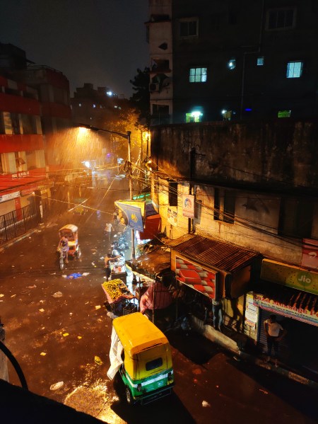
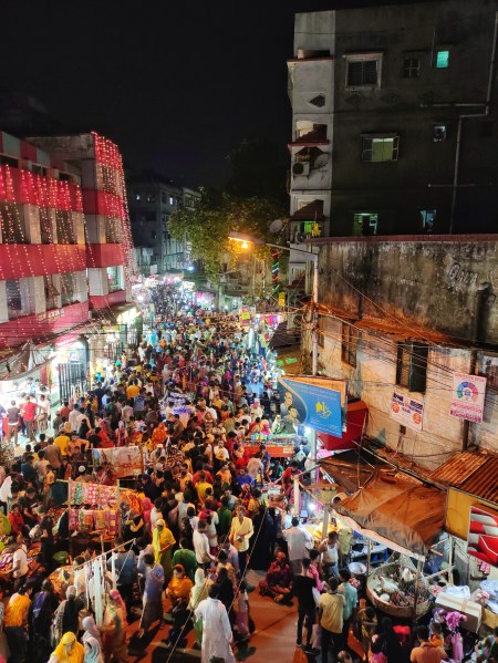
To represent the extraordinary within the ordinary, the light is put forth to a street in Kolkata, Topsia, recognized by the number ‘90’, has not yet been identified as one of the most alive streets of the city of joy yet they have the metaphysical fundamentalism. The street is particularly a connectivity to one of the Muslim populated locality of the place. The majority of the population living in the locality belongs to the middle class strata of society. They adapt themselves to the concept of ‘less is more’3 and seek the intangible aspects of the spaces that they use. Considering the theories relating to the energy sources, streets becomes the most dynamic element that could be considered as the life of the whole city. They deal with more than the vehicular and pedestrian movement. The streets deal with the dialects of dynamics of metaphysical consequences.
Figure 1: Layout of Streets of Kolkata; source: author.
Within and outside the realms of architecture, streets pave the way at the microcosmic level for the energy distribution network similarly to the way it functions for the crowd and vehicular activity. The metaphysical lens from different frames of reference gives an opportunity to analyze the impact of the metaphysical link and how it is evoked with the crowd in context to the existing surrounding. Different users feel a variety of different emotions in consideration to one particular space.
Figure 2: The Street ‘90’ on 12th June, 2019; source: author.
A resident of the place when asked about her experiences with the place said, “We have been staying here for about 15-18 years now. It has an essence of familiarity and home. The existing buildings, the shopkeepers, the vendors, and when I say vendors I really mean it. They are accurate with their location of stalls and wouldn’t trade it with anyone. Ive seen a lot of changes in the place. The building in red and white was built after demolition of an old 3-storey building for commercial purpose yet the upper floors still remain untouched after being built for so many years. The chaos is the essence of this place and without it, this street will lose its essence and identity.”
Considering the quantitative aspect of the street, it is about ten meters in width, with two meters of it occupied by the street vendors. An analysis of the street was done in three different phases of the day. When the morning struck, the silence is disturbed only by the daily activities of parents dropping off their half-dozed children to schools either by private or public convenience, which here is the auto rickshaws, who typically place themselves along the edge of the building as shown in Figure 2. Slowly and gradually as the time transcends the vegetable and fruit vendors take the edge of the street as their potential business spot. The traffic becomes evident by the noon with children coming back from school, having there go at the Sharbet waalas. As soon as the sun goes down, the street has an overwhelming response by the users creating itself in a chaotic mess of disoriented vehicles and people trying to make way to get out. Simultaneously, the sequence of functioning of the streets inflects thrrough its natural course. The female crowd encircles the ‘puchka waale bhaiya’, drooling over the smell of the tamarind water. A few steps towards the east would bring us to a smellscape of a multi-cuisine food corner with a large hot plate with parathas being fried, a traditional clay barbeque for the kebabs being cooked upon the coals, another man assorting the shelves with momos, fried crispy chicken and another struggling with delivering the order to the respective customers superimposing each other tones in a competitive streak to get their order first. The edges of the streets are defined by the utilities of all kind such as a pharmacy, general stores, grocery shops, food kiosks and corners, markets within a radius of a hundred meters, a shopping complex built few years back, occupied only the ground floor of the building structure. A fruit vendor defined the street as, “It is a metaphor of how our life is, always moving and moving in the forward direction. Despite the chaos we love our life so do we love this place.”
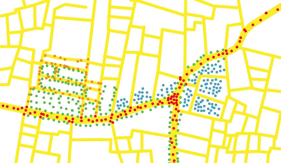
Figure 3: The Feeling Mapping of the Street (red-chaos, green- rejuvenation, orange-action, blue-contentment); source: author
The rhythm of the basic functioning of the street is inflected during the festivities, such as the two Eids and Muharram. The zeal within the crowd becomes evident and the streets stop serving as a vehicular access instead it becomes a hub of utilities as shown in Figure 4.
Figure 4: The Street ‘90’ on 4th June, 2019 (On the Eve of Eid); source: author
In terms of architectural analysis, the flaws couldn’t remain unseen, but what the architects couldn’t see is the intrinsic experiences that the users have with the place. The elegance of the street is a culture of contentment and containment. It depicts the unification of the users belonging to all strata of the society interacting with each other whatever the purpose may be. The dynamics of the streets and the humans represent a whole of the community be it the rich or the poor. In a simple world, the whole of the world can be explored. The local architectural vocabulary of the streets shows motions and emotions of all colours. It depicts joy as well as sorrow. The chaos and the peace, all the comedies and tragedies. The energy drained is rejuvenated with the constant flow of energy on the street. The essence of the chaos in itself shows the intrinsic connection between the built and the unbuilt. The street evokes the intangible aspects of the userrs. The user activity is the result of the concentrated energy source at the micro cosmic level connecting humans with the space at a deeper level. Configuration of the whole of the city is determined by the streets that becomes the highest sources of energy flowing throughout. The built is to exist what the unbuilt is to life. The boundaries defined by the concrete is a personalized space to exist in harmony, but to co-exist, an undefined yet the key that holds the city together. A street has a potential to turn itself into anything it wants. The street is an induced public space. The street has evolved through the line of time of urbanization inflecting the course of its motion. Due to the increasing number of concrete massing, the spatial contraction of the streets are taking place in localities like Topsia in Kolkata whereas due to the urbanization, the expansion of streets also take place with putting an end to the life of the city creating it in a block of monotony and regularity only used as an access not as a space for creating an interaction between the built and the unbuilt, the known and the unknown. Spatial expansion and contraction taking place to accommodate structures. Street is one part to the whole that encapsulates the built and the user. People have a tendency to experience voids hence, they hold human sentiments. We are dehumanizing the streets by making it lose its existence by the loss of depiction of culture and tradition. It is a lost element with the thoughts drowned in hues of grey unaware of how to survive in the chaos. The task of an architect is to blend imagination with practicality by balancing ideas and reviving the true nature of the streets in context to human activities.
REFERENCES
1. The Holy Quran
2. Mustofa, 2011. According to Dr. R Tatang Santanu Adikara, the Head of Bioenergy Research Centre in Surabaya, human gets energy from two sources: inside the human body and outside the human body.
3. Metaphysical Approach for Design Functionality in Malay-Islamic Architecture, article in procedia-social and behavioral sciences-aug 2015
The life after the pandemic situation will not be normal again as this pandemic situation is also not normal.
Knowingly or unknowingly the virus developed in China (according to news) created the biggest impact in the health and economic sector of the world. Nobody knows how much time will it take to come out completely from this pandemic situation. China with the most power in terms of technology and population might have a master plan to be executed in the name of Novel Corona virus by supplying the goods of medical department and further other essential commodities which might be needed by the people in the near future to the world and soon they will earn billions of dollar by supplying it to the world. So, again now world will depend more on China than before.
We as a responsible citizen of India, need to stop the master plan of China as in the near future it will harm us very very badly. Let us understand by an example, India is surrounded by countries like Pakistan, Bangladesh, Sri lanka, Nepal this all countries have taken huge amount of money from China like wise Pakistan took huge money from China to develop a road passing from the mountain, so now Pakistan is in debt to pay the money and in return China can do anything to gain the money back. Pakistan took more money from China than from IMF, and has to pay around 19 billion US$, which will be extremely hard for Pakistan. In the same way Sri lanka owes 1.4 billion US$ which is left over from from 99 years and now China will ask for payback or will capture the Sri lanka. Bangladesh debt for 64.9 billion US$. India is also in debt of paying to China, but China will not capture India first it will first capture our surrounding countries and than head towards India. So, we need to become very attentive towards each step of China and understand their activity, we also need to stop buying Chinese goods to save our country and instead go for Made In India goods. JAY HIND…
A checklist of some of the issues that must be considered in urban planning, when developing or implementing a policy or design:
Urban sprawl & inefficient use of land causes housing affordability problems, transport problems, and uses up a finite resource.
Transport: In most cases roads dominate, and the development does not support public transport and is unfriendly for walking and cycling.
Design for human scale, rather than cars and commerce. Design should inspire community and create a pleasant living environment.
Community or neighborhood identity adds to the feeling of place and cohesiveness of the community. This is helped by access to most facilities within the local area; a strong local economy (including a local currency or bartering system?) The dominant 20th-century model results in isolation, lack of familiarity with neighbors (which contributes to crime) and many more trips out of the neighborhood (esp by car).
Single use vs mixed use developments. Since the rise of the car, Recent decades have favored single use; mixed use may enable more needs to be met locally.
Environment: water & waste.
Environment: energy usage.
Affordability and accessibility. The social impact of housing costs.
Regional development – decentralization, revitalization of country towns. How, and ask: Why is it needed, why have people left?
To plan or not to plan?
Overarching vision and plan? Or a few simple principles to encourage sustainability and quality of life? Note that suburban sprawl was created with regulations, and traditional neighborhoods which grew into the most vibrant and desirable parts of cities had much less regulation, and would certainly not be permitted today.
Need for participation by local communities, and ultimate say in their own communities.
Existing communities: gradual & staged improvements. How to create community? How to achieve appropriate density and affordable housing, when residents natural tendency is to fight change, especially change that might negatively affect their house prices.


You must be logged in to post a comment.