Vichar Nyas Foundation


The planning system is meant to reflect the general wishes of the local community and there is a need on the local authority to consult widely during the formulation of a local plan and in the operation of the development. The fact that the council is made up of elected members ensures a certain level of representation, but wider public consultation is required. When a planning application is submitted the local authority publishes details in the local newspaper and, in some circumstances, a notice is displayed adjacent to the site. In cases of special sensitivity, individual households in an affected area might be asked for their opinions or there may be a small public exhibition.
However, in most cases, if members of the public wish to find out what is proposed they have to visit the planning department, request the material that has been submitted and examine it on the premises. They can then write to the planning committee if they have any objections. No matter what the scale of proposal, development control can be thought of as a process of negotiation: at its simplest, between the applicant and the local authority, with only rudimentary involvement by the public.
Although any given participation process does not automatically ensure success, it can be claimed that the process will minimize failure. It is a source of wisdom and information about local conditions, needs and attitudes, and therefore improves the effectiveness of decision making. It is a means of defending the interests of groups of people and of individuals, and a tool for studying their needs, which are often ignored and dominated by large organizations, institutions and their bureaucracies. With the goal of achieving agreement about what the future should bring.
The planning that accompanies the design of any participation program should first include a determination of participation goals and objectives. Participation goals will differ from time to time and from issue to issue. Participation is likely to be perceived differently depending on the type of issue, people involved and political setting in which it takes place. If differences in expectations and perception are not identified at the outset, and realistic goals are not made clear, the expectations of those involved in the participation program will likely not be met, and people will become disenchanted. To address participation effectively, the task should conceptualize what the objective is for involving citizens. For example, is the participation intended to;
Once planners have identified the overall goals and objectives for the participation process, Planning for participation requires the following steps;
A wide range of techniques are available to designers and planners. Some of these techniques have become standard for use in participatory processes, such as interactive group decision making techniques that take place in workshops. At the same time, designers and planners have effectively used field techniques, such as questionnaires, interviewing, focus groups, and group mapping, to acquire information. In general, many of the techniques facilitate citizens awareness of environmental situations and help activate creative thinking. The techniques can be classified as awareness methods, group interaction methods and indirect methods.
Planning Standards are formulated by the Town and Country Planning Department normally in the form of codes or regulations pertaining to space requirement, site specification, height, land use and other criteria required by the local authority for development of land or property These standards are applied during the planning/design stage of a project/preparation of layout. These standards are applied during the planning Normally in the form of codes/design stage of a project/preparation of layout.
With the idea of having a uniform standard for reference and adoption by town planners, architects and engineers in India, the Institute of Town Planners, the School of Planning and Architecture and the Town and Country Planning Organization, New Delhi, tried to evolve certain planning standards. Planning organizations, like the Delhi Development Authority, the Bangalore Metropolitan Planning Board and the Calcutta Metropolitan Planning Organization have also adopted some standards in the preparation of master plans for the respective metropolitan cities.
When these standards are compared, it is observed that there is disparity between them and also between the standards adopted in India and those in other countries. Hence, an attempt is made here to evolve workable standards for reference and adoption by persons concerned with urban and regional planning in India. The list is not exhaustive and there is large scope for improving the standards, taking into consideration the latest techniques and theories. The role of architects and engineers in this task is also very important, as they have rich experience in evolving such standards in their respective fields of study. It is hoped that the start made by the Institute of town planners and other organizations would be continued and town planners in India would adopt uniform standards in their profession.
The proposed standards will be useful for ready reference by practicing town planners, architects, engineers, students and planning organizations including local bodies in their planning work. They will be of great help to those responsible for making policy programmes and recommendations on urban and regional planning and in developing town planning techniques on the ‘systems engineering’ method. In the absence of uniform standards, the authenticity of the standards adopted by any town planner in the country will be open to question. Hence, such standards, apart from being useful in the technical work, save the town planner from adverse comments and unhealthy criticisms.
Space planning is a complex process with many factors to consider. The principles of space planning involve satisfying a defined criteria on a priority basis – as a result, space planning is frequently about compromise. That being said, there is often more than one solution to planning out the space requirements of a building.
City or Town is a place of urban living. Urban means an environment in which natural surroundings have been dominated by manmade or artificial surroundings, which man made for himself, or his working, living and recreation. As per the census of India, a place becomes urban if it has more than 5000 population, more than 75% of which are engaged in non –agricultural occupation and the density is more than1000 persons per sq.km.
Urbanization is the physical growth of rural or natural land into urban areas as a result of population immigration to an existing urban area. Urbanization refers to the population shift from rural to urban residency, the gradual increase in the proportion of people living in urban areas, and the ways in which each society adapts to this change.
The Causes of Urban Growth
Push Factors
· Lack of educational facilities
· Lack of job opportunities
· Lack of health facilities
· Lack of electricity and sewerage system
· Land lord system
· Inequality
· Low living standards
· Old traditions
Pull Factors
· Better and higher educational facilities
· Better and more of job opportunities
· Better health facilities
· Availability of electricity and sewerage system
· Better living standards
In 1960, the global urban population was 34% of the total; however, by 2014 the urban population accounted for 54% of the total and continues to grow. By 2050 the proportion living in urban areas is expected to reach 66%. Fig. 1.5 shows the change in the rural and urban populations of the world from 1950 through to projected figures up to the year 2050.
Urbanism started in the caves themselves, where people gathered for protection against the elements or for the defence against rival tribes. These places of communal living gave way to the village. The village was a by-product of development of agriculture in areas of adequate water supply and fertile soil. The village was also a sanctuary for the altar of their deity, a meeting place for assembly and a centre for trade. This environment became increasingly populated and resulted in urbanisation. With the development of diversified economy not totally dependent of food production attracted people into labour pool, providing employment in a variety of forms. This in turn brought about the enlargement of village or hamlets into towns and cities.

Urban and rural population of the world, 1950–2050
Population residing in urban areas in India, according to 1901 census, was 11.4%. This count increased to 28.53% according to 2001 census, and crossing 30% as per 2011 census, standing at 31.16%. In 2017, the numbers increased to 34%, according to The World Bank. The data shows that Goa is the most urbanised state with 62.17% of the population living in urban areas. But if one goes by geographical area and total population, Tamil Nadu is the most urbanised state. In Kerala, 47.72% of people live in urban areas and in Maharashtra 45.23%.
Factors that influence in the development and growth of urban areas
· Population density
· Density of physical development
· Possession of formal plan
· Proportion of inhabitants engaging in non agricultural occupation
· Functional characters
· Services
· Political or legal, administrative
· Life style
Causes of urbanization
· Economic development
· Industrialization
· Job opportunities
· Availability of easy transportation
· Agglomeration economics
· Political, cultural and social influences
Problems of Urbanization
· Pressure on resources and social services Eg. Water, transport, health and education
· More unemployment
· Increased crime rate, especially since the typical migrant may be young, unskilled or inexperienced
· Development of slums (ghettos) due to inadequate housing. This will add to the problem of pollution
· Traffic congestion
· Competition on limited resources
· Noise pollution
· Epidemics
· High levels of stress
· Poverty
· Air quality worsens
Solution to problems of urbanization
· Limit the size of cities by setting boundaries and controlling population size
· Put a stop to using agricultural lands for non-agricultural purposes such as housing
· Develop the rural areas by providing recreation, education, health care and other social services
· Develop basic infrastructure in the rural areas eg. roads, water and electricity
· Encourage rural population to participate in community activities and use community facilities
· Create jobs in rural areas by building more factories to employ more people
JNNURM (Jawaharlal Nehru National Urban Renewal Mission) is the first massive urban development programme in India and has established the foundation for large-scale central assistance to the urban sector. It was launched as a reform-driven and fast-track programme to catalyze planned development of identified cities. The programme has been operating in mission mode by facilitating large scale investments in the urban sector and policy and institutional reforms, leading to sustainable socio-economic growth in cities. The mission has sought to achieve this by integrating the development of infrastructure services and accelerating the flow of investment into urban infrastructure; through planned development, redevelopment and renewal of cities, inner-city areas, peri-urban areas, outgrowths, urban corridors and through universal service delivery for the urban poor. A number of urban projects were sanctioned under JNNURM during 2005–2014, and central assistance of approximately 48,000 crore INR was committed during this period through the mission. During 2014–15, the central government launched four new schemes to expedite urban infrastructure and service provision and replace JNNURM. These schemes are the Atal Mission for Rejuvenation and Urban Transformation (AMRUT), focusing on water supply and sewerage improvement; Smart Cities Mission (SCM), aimed at developing smart solutions for selected urban areas; Swachh Bharat Mission (SBM), focused on waste management and sanitation; and Heritage City Development and Augmentation Yojana (HRIDAY), for addressing the development of heritage cities.
In India, the various states have passed town planning act to enforce town planning activity. The main source of all these town planning acts are the English Town Planning Act of 1909, the main provision in this act is that local authorities are given power to prepare and to enforce town planning schemes on open lands in the city and on its fringe.
For the purpose of looking after the planning and execution of new parts within metro-centres, various organizations such as DDA (Delhi Development Authority), CIDCO (City and Industrial Development Corporation), CMPO (Calcutta Metropolitan Planning Organization), HUDCO (Housing and Urban Development Corporation), etc., are set up by the government.In addition to local authorities, the State Government is empowered to declare urban development areas and to set up urban development authorities for such areas. Such authorities are given the following powers.
Socio – Economic Aspects of Town Planning
The town planning is desirable if its adoption leads to better utilization of the resources of the community. Hence, for any given size, the best planned town is one where the aggregate land values are at a maximum. Thus, economically, the best town plan will lead to the highest aggregate land values. While adopting the land values condition, the following factors are to be considered for assessing the economic worth of town planning.
The economic advantages offered by urban way of life are enormous. But at the same time, urban growth is not smooth and there are many difficulties that prevent the town from making maximum contribution to national economy. Some of the economic disadvantage can be mentioned as difficulties in securing housing accommodation, congestion of facilities, etc. In a similar way, the drawbacks from various disciplines can be enumerated as follows.

Nuclear and Radiological Emergency
The growth in the application of nuclear science and technology in the fields of power generation, medicine, industry, agriculture, research and defence has led to an increase in the risk of occurrence of Nuclear and Radiological emergencies.
India has traditionally been vulnerable to natural disasters on account of its unique geo climatic conditions and it has, of late, like all other countries in the world, become equally vulnerable to various man-made disasters.
Nuclear and Radiological Emergency can arise in a nuclear facility at plant level leading to plant/ site or offsite emergency depending upon the extent of its impact on the surroundings. It can also take place while using radiation sources, either at Hospitals, Industries, Agriculture or Research Institutions due to loss or misplacement or due to faulty handling. The other events that can lead to Nuclear or Radiological Emergency in the public domain, include, accident of a vehicle carrying radioactive/nuclear material, due of an orphan source i.e. the source which is not under regulatory control or due to usage of radiation source/radioactive material in Malevolant activities.
Any radiation incident resulting in or having a potential to result in exposure and/or contamination of the workers or the public in excess of the respective permissible limits can lead to a nuclear/radiological emergency.
Sad memories of the use of nuclear weapons dropped on Hiroshima and Nagasaki, and the wide publicity given to the reactor accidents at Three Mile Island (TMI) in USA and Chernobyl in erstwhile USSR, have strongly influenced the public perception of any nuclear or radiological emergency to be most often linked, erroneously though, to only these events. However, one must be prepared to face nuclear/radiological emergencies of lower magnitudes and ensure that the impact of such an emergency (which,for a given magnitude, is likely to be much greater today because of higher population densities coupled with an enhanced urban infrastructure due to economic prosperity) is always kept under control. It may be noted that better infrastructure can be helpful during such incidences in terms of enhance communication, transport and medical support.
For improving the quality of life in society, India has embarked upon a large programme of using nuclear energy for generation of electricity. As on date, India has 20 power reactors and three research reactors in operation along with five power reactors under construction. It is also planned to explore setting up Thorium based reactors to meet its ever increasing energy needs. The country is also at the verge of making operational the first 500MW prototype Fast Breeder Reactor (PFBR) after a prolonged experience of operation of FBTR (Fast Breeder Test Reactor). Further, the country utilises adioisotopes in a variety of applications in the non-power sector, viz., in the field of industry, agriculture, medicine, research, etc. Due to the inherent safety culture, the best safety practices and standards followed in these applications and effective regulation by the Atomic Energy Regulatory Board, the radiation dose to which the persons working in nuclear/radiation facilities are exposed to, is well within the permissible limits and the risk of its impact on the public domain is very low.
However, nuclear emergencies can still arise due to factors beyond the control of the operating agencies; e.g., human error, system failure, sabotage, earthquake, cyclone, flood, etc. Such failures, even though of very low probability, may lead to an on-site or off-site emergency. To combat this, a number of system upgrades have been planned to mitigate/prevent such emergencies. However, proper emergency preparedness plans must be in place so that there is minimum avoidable loss of life, livelihood, property and impact on the environment.
Preparedness at Nuclear Facilities
The probability of a major accident at nuclear facilities leading to the release of large quantities of radioactivity into the environment is always ensured to be negligibly small. However, even in the event of a major release into the environment, the prompt and effective implementation of countermeasures can reduce the radiological consequences for the public and the environment.
Preparedness for Nuclear/Radiological Emergencies
The handling of nuclear emergencies requires coordination among different service groups of the nuclear facility. In the event of potential radiological consequences in the public domain, all the authorities at the three levels, i.e., district, state and central, will play a vital role and assist the offsite officials in effectively responding to and keeping the public informed on the precautions to be taken.
Major Responsibilities of Nuclear Power Plant Operators
This includes the arrangements required to promptly classify an emergency, mitigate the emergency, notify and recommend protective actions off the site consistent with international guidelines, protect those on site, obtain off-site assistance, conduct environmental monitoring of the affected area and assist off-site officials in keeping the public informed.
Major Responsibilities of Off-Site Officials
This includes the arrangements required to promptly implement protective actions and countermeasures in the affected area.
Emergency Preparedness for Nuclear Power Plants
Since the proper implementation of countermeasures can significantly reduce the consequences of an emergency situation, it is mandatory for all nuclear facilities that there must be a comprehensive emergency preparedness plan. Prior to the issuance of a license for the operation of a nuclear facility, the AERB ensures that the facility has the Emergency Response Manuals for the three main types of emergencies, viz., plant, on-site and off-site, and that the plans are in place to handle these types of emergencies. The operators of nuclear facilities must make an assessment of the type and quantum of release of radioactivity under various accident conditions and the extent to which it can spread into the environment.
Plant Emergency
When the radiological consequences of an abnormal situation are expected to remain confined to the plant boundary or a section of the plant, it is described as a plant emergency. Nuclear facilities in the country already have the following provisions for the detection, classification, notification and mitigation of any emergency situation:
On-Site Emergencies
An accidental release of radioactivity or the potential of release of activity extending beyond the plant, but confined to the site boundary, constitutes a site emergency condition. In addition to all the provisions applicable in a plant emergency, the following additional provisions are ensured:
Off-Site Emergencies
On recognising the potential for an uncontrolled release of radioactivity into the public domain, the concerned district authorities are alerted to be on standby for emergency response operations. In addition to all the provisions applicable in plant emergency and site emergency, the following additional provisions are to be ensured for handling a nuclear emergency in the public domain:
For handling of an off-site emergency condition in an NPP, there is an off-site emergency committee headed by the district magistrate of the concerned district and supported by the district subcommittee, which include chiefs of all public service departments relevant to emergency management in the district and also the Head of the Site Emergency Committee of the nuclear facility for technical advice. This committee takes decisions pertaining to the handling of a nuclear emergency outside the site boundary and ensures implementation of countermeasures such as sheltering, prophylaxis and evacuation and resettlement, including maintenance of law and order and civil amenities. All the activities pertaining to the handling of an off-site emergency are guided and coordinated from a pre-designated emergency response centre located outside the boundary of the nuclear facility. The information and broadcasting department of the district, in association with an authorised information officer, ensures the smooth flow of information to the media to avoid panic and spreading of rumours.

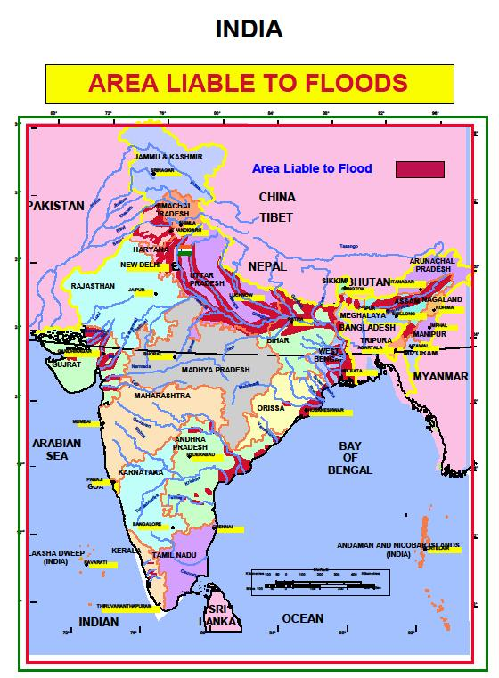
India is highly vulnerable to floods. Out of the total geographical area of 329 million hectares (mha), more than 40 mha is flood prone. Floods are a recurrent phenomenon, which cause huge loss of lives and damage to livelihood systems, property, infrastructure and public utilities. It is a cause for concern that flood related damages show an increasing trend. The average annual flood damage in the last 10 years period from 1996 to 2005 was Rs. 4745 crore as compared to Rs. 1805 crore, the corresponding average for the previous 53 years. This can be attributed to many reasons including a steep increase in population, rapid urbanization growing developmental and economic activities in flood plains coupled with global warming.
An average every year, 75 lakh hectares of land is affected, 1600 lives are lost and the damage caused to crops, houses and public utilities is Rs.1805 crores due to floods. The maximum number of lives (11,316) was lost in the year 1977. The frequency of major floods is more than once in five years.
Floods have also occurred in areas, which were earlier not considered flood prone. An effort has been made in these Guidelines to cover the entire gamut of Flood Management. Eighty per cent of the precipitation takes place in the monsoon months from June to September. The rivers a bring heavy sediment load from catchments. These, coupled with inadequate carrying capacity of rivers are responsible for causing floods, drainage congestion and erosion of river-banks. Cyclones, cyclonic circulations and cloud bursts cause flash floods and lead to huge losses. It is a fact that some of the rivers causing damage in India originate in neighboring countries; adding another complex dimension to the problem. Continuing and large-scale loss of lives and damage to public and private property due to floods indicate that we are still to develop an effective response to floods. NDMA’s Executive Summary Guidelines have been prepared to enable the various implementing and stakeholder agencies to effectively address the critical areas for minimising flood damage.

Emergency Kit
Urban Floods
Urban flooding is significantly different from rural flooding as urbanization leads to developed catchments, which increases the flood peaks from 1.8 to 8 times and flood volumes by up to 6 times. Consequently, flooding occurs very quickly due to faster flow times (in a matter of minutes). Urban areas are densely populated and people living in vulnerable areas suffer due to flooding, sometimes resulting in loss of life. It is not only the event of flooding but the secondary effect of exposure to infection also has its toll in terms of human suffering, loss of livelihood and, in extreme cases, loss of life.
Urban areas are also centres of economic activities with vital infrastructure which needs to be protected 24×7. In most of the cities, damage to vital infrastructure has a bearing not only for the state and the country but it could even have global implications. Major cities in India have witnessed loss of life and property, disruption in transport and power and incidence of epidemics. Therefore, management of urban flooding has to be accorded top priority.
Increasing trend of urban flooding is a universal phenomenon and poses a great challenge to urban planners the world over. Problems associated with urban floods range from relatively localized incidents to major incidents, resulting in cities being inundated from hours to several days. Therefore, the impact can also be widespread, including temporary relocation of people, damage to civic amenities, deterioration of water quality and risk of epidemics.
What to Do After Floods
Emergency Kit
Prepare a safety kit which should include a torch, sheets/ blankets, waterproof clothing, battery-operated radio, bottled water, first-aid kit, medication, personal valuables and personal documentation.
Guidelines
As a part of its mandate, the National Disaster Management Authority (NDMA) has made efforts to prepare the National Guidelines on Management of Urban Flooding. Even though urban flooding has been experienced over decades in India but sufficient attention was not given to plan specific efforts to deal with it. In the past, any strategy on flood disaster management largely focused on riverine floods affecting large extents of rural areas. Mumbai floods of July 2005 turned out to be an eye-opener. Realizing that the causes of urban flooding are different and so also are the strategies to deal with them, NDMA has for the first time decided to address urban flooding as a separate disaster, delinking it from floods.
URBAN FLOOD RISK IN INDIA
There has been an increasing trend of urban flood disasters in India over the past several years whereby major cities in India have been severely affected. The most notable amongst them are Hyderabad in 2000, Ahmedabad in 2001, Delhi in 2002 and 2003, Chennai in 2004, Mumbai in 2005, Surat in 2006, Kolkata in 2007, Jamshedpur in 2008, Delhi in 2009 and Guwahati and Delhi in 2010.
A special feature in India is that we have heavy rainfall during monsoons. There are other weather systems also that bring in a lot of rain. Storm surges can also affect coastal cities/ towns. Sudden release or failure to release water from dams can also have severe impact. In addition, the urban heat island effect has resulted in an increase in rainfall over urban areas. Global climate change is resulting in changed weather patterns and increased episodes of high intensity rainfall events occurring in shorter periods of time. Then the threat of sea-level rise is also looming large, threatening all the coastal cities. Cities/towns located on the coast, on river banks, upstream/ downstream of dams, inland cities and in hilly areas can all be affected.
ISSUES IN URBAN FLOODING
Among the important cities of India, the average annual rainfall varies from 2932 mm in Goa and 2401 mm in Mumbai on the higher side, to 669 mm in Jaipur on the lower side. The rainfall pattern and temporal duration is almost similar in all these cities, which receive the maximum rainfall from the south-west monsoons. The average rainfall for the month of July in Mumbai is 868 mm and this far exceeds the annual average rainfall of 611 mm in London.
Stormwater drainage systems in the past were designed for rainfall intensity of 12 – 20 mm. These capacities have been getting very easily overwhelmed whenever rainfall of higher intensity has been experienced. Further, the systems very often do not work to the designed capacities because of very poor maintenance. Encroachments are also a major problem in many cities and towns. Natural streams and watercourses have formed over thousands of years due to the forces of flowing water in the respective watersheds. Habitations started growing into towns and cities alongside rivers and watercourses. As a result of this, the flow of water has increased in proportion to the urbanization of the watersheds. Ideally, the natural drains should have been widened (similar to road widening for increased traffic) to accommodate the higher flows of stormwater. But on the contrary, there have been large scale encroachments on the natural drains and the river flood plains. Consequently the capacity of the natural drains has decreased, resulting in flooding. Improper disposal of solid waste, including domestic, commercial and industrial waste and dumping of construction debris into the drains also contributes significantly to reducing their capacities. It is imperative to take better operations and maintenance actions.
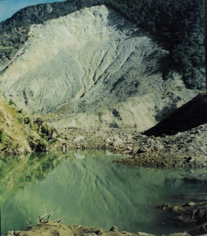
India has the highest mountain chain on earth, the Himalayas, which are formed due to collision of Indian and Eurasian plate, the northward movement of the Indian plate towards China causes continuous stress on the rocks rendering them friable, weak and prone to landslides and earthquakes. The slow motion of the Indian crust, about 5 cm/year accumulates stress to which natural disasters are attributed. Some landslides make unique, and unparalleled catastrophes. Landslides and avalanches are among the major hydro-geological hazards that affect large parts of India besides the Himalayas, the Northeastern hill ranges, the Western Ghats, the Nilgiris, the Eastern Ghats and the Vindhyans, in that order, covering about 15 % of the landmass. The Himalayas alone count for landslides of every fame, name and description- big and small, quick and creeping, ancient and new. The Northeastern region is badly affected by landslide problems of a bewildering variety. Landslides in the Darjeeling district of West Bengal as also those in Sikkim, Mizoram, Tripura, Meghalaya, Assam, Nagaland and Arunachal Pradesh pose chronic problems, causing recurring economic losses worth billions of rupees. A different variety of landslides, characterized by a lateritic cap, pose constant threat to the Western Ghats in the South, along the steep slopes overlooking the Konkan coast besides Nilgiris, which is highly landslide prone.
Some spectacular events of tragedies are reported as Varnavat landslide, Uttarkashi District, Malpha landslide Pithoragarh district, Okhimath landslide in Chamoli district, UK and Paglajhora in Darjeeling district as well as Sikkim, Aizawl sports complex, Mizoram.These are some of the more recent examples of landslides. The problem therefore needs to be tackled for mitigation and management for which hazard zones have to be identified and specific slides to be stabilized and managed in addition to monitoring and early warning systems to be placed at selected sites.

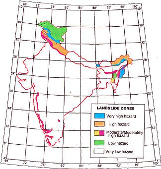
A general landslide hazard map of India shown here marks the areas of different hazard zones in various states of India; one may note that Himalayas of Northwest and Northeast India and the Western Ghats are two regions of high vulnerability and are landslide prone.

NDMA guidelines are being followed for Landslide Hazard Zonation (LHZ) maps at 1: 50,000 scale and progressively larger scales for specific areas. National Remote Sensing Center (NRSC),Department of Science and Technology (DST), Council of Scientific and Industrial Research (CSIR), Indian Institute of India (IITs), Universities have done tremendous work in this regard. The NRSC Atlas on selected corridors of Uttarakhand and Himachal Pradesh has been a very useful Atlas (Please see NRSC work on Landslides). DST has funded more than 30 projects spread over India by various academic institutions the reports of which can be requested from DST (NRDMA).
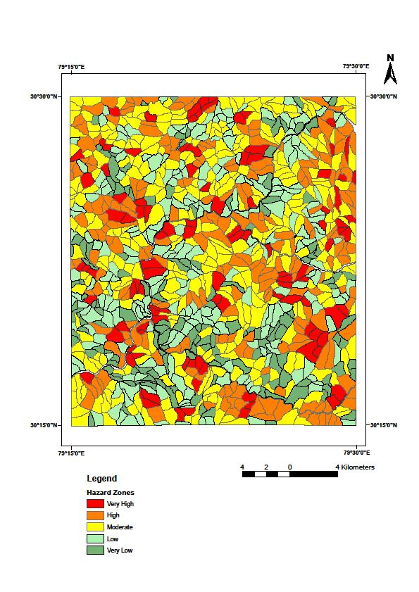
An example of LHZ map at 1: 50,000 scale from a part of Himalayas in Chamoli district (Pachauri, 1992) shown here is based upon several geological, geotechnical parameters. Such maps are being refined and relooked for higher level of verification and acceptability for public use. Approximately 15 % of the Indian landmass has to be covered by such maps at 1: 50,000 scale or higher to classify slopes in various levels of hazards. Geographical Information System (GIS) and Remote Sensing applications are being used through NRSC under a special group of GIS for LHZ at NDMA through database collection from all concerned departments and being stored through good offices of GIS and other agencies, CSIR labs, DST etc as a parallel theme on landslide mitigation.

Emergency Kit
Recover and build
Remain calm and be alert and awake, listen to warnings of heavy and prolonged period of rainfall from weather station, if your home is located below a debris covered area move away to safer place, listen to sounds of rock fall, moving debris and cracking of trees, or cracks in ground or any movement. Keep a battery operated ready for the night.
Call and help rescue teams, keep drinking water containers, first aid kit and essential medicines and avoid entering damaged houses.
Watch for flooding if close to river, help others who need help especially elderly people, children and women, seek advice from local authorities for rebuilding damaged houses, roads etc.
Report any damage of roads, power and telephone lines to concerned authorities.
A Heat Wave is a period of abnormally high temperatures, more than the normal maximum temperature that occurs during the summer season in the North-Western parts of India. Heat Waves typically occur between March and June, and in some rare cases even extend till July. The extreme temperatures and resultant atmospheric conditions adversely affect people living in these regions as they cause physiological stress, sometimes resulting in death.
The Indian Meteorological Department (IMD) has given the following criteria for Heat Waves :
Higher daily peak temperatures and longer, more intense heat waves are becomingly increasingly frequent globally due to climate change. India too is feeling the impact of climate change in terms of increased instances of heat waves which are more intense in nature with each passing year, and have a devastating impact on human health thereby increasing the number of heat wave casualties.
Health Impacts of Heat Waves
The health impacts of Heat Waves typically involve dehydration, heat cramps, heat exhaustion and/or heat stroke. The signs and symptoms are as follows:
Recover and Build
If you think someone is suffering from the heat:
Emergency Kit
You must be logged in to post a comment.