
An Amoral Nation

“Who are you voting for and why?” asked one TV reporter seeking the pulse of prospective voters in a pivotal state. Not a single person responded by citing political or ethical principles. The Romney voters didn’t point to the prospects of protecting individual rights, free markets, or the virtues of self-reliance. The Obama supporters were silent on redistribution, socialism, and the evils of capitalism. The average voter shows a complete lack of cognizance of principles–any principles. They expressed one overriding concern: who will give me “more stuff?”

It wasn’t always overt. Many talked about “sincerity” while others fretted that the candidates are “hard to believe.” A whole host of other character traits were bandied about in assessing which candidate can be trusted. But trusted to do what? In each case our fellow citizens weren’t concerned about the health of the republic–which only principles can insure. They merely wanted to know who will give them “more stuff” now.

There was a completely amoral tone that the permeated the conversations. And it reflects the campaign of both candidates. Obama is clear: he lists all the “free stuff” he’ll give you while making it clear you won’t have to pay for it. He’d fund it from the top 1-2 percent of high earners. You don’t have to work and earn it–as virtue would require. You’ll get someone else’s hard earned wealth–as expediency allows. Mere expediency is the antithesis of principle. If we can get away with expropriating others wealth for now, let’s do it. If they “go Galt” tomorrow … well, tomorrow will be another day.

What does Mr. Romney offer in return? In the second debate he assures us that the “top 5 percent will continue to pay 60 percent, as they do today. I’m not looking to cut taxes for wealthy people. I am looking to cut taxes for middle-income people.” You’ll still get the government goods and services but you won’t have to pay for it. We’ll still get the rich to foot the bill. No principle is cited and none can be detected. Why, then, would we expect to see the voter apply principles to make an informed choice? When it comes to the expedient of getting “free stuff” paid by the rich, who is more believable?

The choice of principle versus mere expediency is exemplified by the President’s addition of $5 trillion to the debt. If our nation was founded on the virtues of industry and frugality (as Ben Franklin would express it), then what could be more profligate than uncontrolled spending funded by overwhelming debt? Mere expediency allows one to weigh the pleasures of today–which are concrete–while downplaying the costs of tomorrow–which are not in sight. To quote our President, “We don’t have to worry about it short term.”

Prudence is another virtue prized by our founding fathers. Living beyond one’s means is recklessness. Excessive borrowing allows one the expedient of funding government services in the short run while deferring payments to the future. The President admits it: “Right now interest rates are low because people still consider the United States the safest and greatest country on earth, rightfully so, but it is a problem long term and even medium-term.” Actually, it’s the Fed that is artificially lowering rates but regardless of the cause we have what is known as a “teaser rate” that will someday reset higher similar to the reckless subprime lending that allowed borrowers to get low monthly payments with “teaser rates.” Let’s remember what profligate borrowing did to the private sector as we ponder what’s in store for the federal government. But “we don’t have to worry about it short term.”

Romney gets credit for making this a moral issue in the first debate. “I’m glad you raised that, and it’s a — it’s a critical issue. I think it’s not just an economic issue, I think it’s a moral issue. I think it’s, frankly, not moral for my generation to keep spending massively more than we take in, knowing those burdens are going to be passed on to the next generation and they’re going to be paying the interest and the principal all their lives. And the amount of debt we’re adding, at a trillion a year, is simply not moral.”

Bravo! Principles are long-term in nature. And Romney returned to enduring principles towards the end of his first debate when he said: “The Constitution and the Declaration of Independence. The role of government is to promote and protect the principles of those documents.” He discussed “life, liberty, and the pursuit of happiness” but these principles weren’t deployed through out his first debate as arbiters of policy; and they were totally absent from the second debate.  It was Obama, in the second debate, who said “I believe that the free enterprise system is the greatest engine of prosperity the world’s ever known. I believe in self-reliance and individual initiative and risk takers being rewarded.” Yet every policy he advocates takes us down the road to socialism. Principles are not slogans. They aren’t boilerplate rhetoric inserted to pay homage to our past. They must be deployed in the present. Each policy must be brought forth and judged in light of the principles. They must be the arbiter of one’s policy decision as one asks is this consistent with our fundamental principles or does this contradict our principles? Neither candidate employed principles in their analysis during the second debate.

If we are talking about the principle of self-reliance we must continually ask “who earn this?” and “who does this rightfully belong?” Instead the candidates only discuss “who gets more?” at the expense of the rich or future taxpayers. A virtuous person cares how they get their wealth. An honorable person aspires to earn it. Even those temporarily down on their luck can and usually maintain their aspirations to be productive members of society. 

A candidate can prove they respect the principle of “self-reliance” if they defend the property rights of every individual who rightfully produced and earned his wealth. Obama contradicts this principle and Romney shies way from it. A candidate can prove they respect the inalienable right to life, liberty, and property, when they insure that every individual can freely act to further his life, run his business, spend his earnings, and live according to his deepest spiritual values. Obama believes in paternalistic government as he has increased “regulations” to the point of strangling the economy. It’s not clear what Romney believes anymore in this regard.

The questioners in the Hofstra debate, as those asked by the man in the street, show that people want “more stuff” whether they’ve earned it or not. If Obama was smiling during the second debate, it was because he knows he was in his element. Unless Romney explicitly names and challenges the crass amoral expediency implicit in “give me more free stuff now,” he doesn’t deserve to win. It is only the dying embers of the torch of liberty in the hearts of our fellow citizens that can save us next month. If we win that reprieve, we must revitalize our culture and re-establish the moral foundation on which our nation was built. No matter who wins, the fight doesn’t end on November 6th. It just begins. 

Remembering as others forget

After reading articles on a dozen conservative websites, it appears that only one had something to say about the movement and religion that was the root cause of the attacks on 9/11. Here is the article by Brigitte Gabriel. Back in 2004 I doubted that conservatives could face the nature of a religious enemy. With a few exceptions that has become true.

The left suspended its usual criticism of religion because of the foreign nature of Islam and the multicultural imperative to praise foreign cultures while denigrating our own. For awhile there were exceptions. Four months after the attack, Daniel Benjamin and Steven Simon, in their book, The Age of Sacred Terror, argued that 9/11 terrorist attacks were purely religious:

But neither President’s necessary and useful political speech should obscure the realities of September 11: the motivation for the attack was neither political calculation, strategic advantage, nor wanton bloodlust. It was to humiliate and slaughter those who defied the hegemony of God; it was to please Him by reasserting His primacy. It was an act of cosmic war. … Only by understanding the religious nature of the attacks of September 11 can we make any sense of their unprecedented scale and their intended effects. 

They clearly repudiated the central thesis of their book when they criticized Sebastian Gorka for the exact same idea saying that “religious doctrine is not their sole or even primary driver.” They were hoping to remain influential in academia and Washington.

The Islamic revivalist movement reached a climax in the creation of the Islamic State. This vivid example of pure Islam in practice was an embarrassment to Islamic apologists everywhere. Even the New York Times couldn’t help but report that ISIS was a salafi creation built on Saudi inspired Wahhabi Islam. Reporters are often the first writers of history. Sadly that history is now lost. History forgotten will be history relived.

Regional Planning

 Region means a tract of land; any area; a portion of earth’s surface. Regional planning deals with the efficient placement of land use activities, infrastructure and settlement growth across a larger area of land than an individual city or town. Regional planning is a sub-field of urban planning as it relates land use practices on a broader scale. Regional planning deals with the planning of areas which constitutes both urban and rural areas. Urban planning, city planning or town planning concerns a city or a delimited urban area which covers a city or town, however a regional plan can have number of urban areas.


A ‘region’ in planning terms can be administrative or at least partially functional and is likely to include a network of settlements and character area. A region scheme usually covers more than one local government area. The content of the scheme may vary for each region, but they generally set out broad land use zones or policy areas and identify land required for regional purposes. Regions require various land uses; protection of farm land, cities, industrial space, transportation hubs and infrastructure, military bases and wilderness. 

Integrating a much wider areas for overall growth of region is the purpose served by regional planning, planning for integration of rural area and the overall balanced development of the region. Fulfilling the needs of a backward region and providing higher order services for relatively developed areas. Strategies are formulated carefully to keep the goods and resources available to all the places as per their requirements.

Regional planning encompasses even larger area when compared to city planning, number of cities might be covered when considering a region but rural area remains at the core for which planning is to be done. Along with rural areas many lower level towns in addition to the villages witnessing transformation to towns also adds up to area for which regional plans is made. Regional plans can cut across the boundaries of different states.

Regional planning also helps in reducing the conflicts and competition for resources between cities in a region. Developing small towns or satellite towns helps in relieving the stress from higher order town thus increasing efficiency. Regional plans takes into account the economic, spatial and environmental goals and tries to address national level issues. Integrated development and critical analysis of functional linkages is one of the key to achieve the desired growth.

Unlike city planning where land use plans are prepared regional planning lays emphasis on policy for the region. Policies are them elaborated and objectives are formed which differ from area to area within the region. Regional plans are a must when cities start to influence development even in far places which might end up in under-utilization and wastage of resources without proper planning.
Polices have a larger and longer impact on the overall growth of region and might conflict with the land use plan or plan prepared for a specific city. Allocation of funds for different activities and different areas can also be taken up by the regional planning board/authority. Government intervention such as implementing a new scheme or policy for a region can also boost the growth perspectives and aide the policy prepared by regional board.

Reduced disparities help directly and indirectly by reducing forced migration, reducing trip lengths, providing better and more job opportunities in nearby areas, having the required services instead of letting them emerging randomly. A Special Economic Zone (SEZ) are also established to support the growth of a region and attract investments.

Regional plans take into account the existing condition of an area and all the surrounding areas. The urban area or the core area might have its own development plan in place for its growth and in such cases the existing plan is also taken into account. The existing plan helps in understanding the vision and growth of the existing urban areas and helps in formulating better policies for the surrounding area. Regional plan might help the existing urban area by decongesting it by catering to the need of satellite cities or developing nearby regions for industrial units.

City Planning & Regional Planning
City planning focuses on the land use plans, spatial growth and policies which are at local level (affecting that particular city or town), whereas in case of regional planning the emphasis on the policies is more. Those policies becomes the guidelines for the urban areas and their existing plans are modified accordingly. This helps in meeting the larger requirement of the whole region.

Additionally, regional plans cover more of national level policies and issues and strengthens integrated development. City planning looks as a limited area when compared to a regional plan. Regional plan covers rural areas and undeveloped areas too which are usually not covered in town plans. The categories, chapters, topics and aspects covered in both plans also differs because of the different needs and the existing developments. Village area, forests, undeveloped land and waste land might be completely missing from a city plans whereas it forms an important part of regional plan.

Importance & Need of Regional Plan
A city or any area might grow in size and hamper the development on its surrounding area. Over the decades it starts competing with the surrounding areas and this results in imbalance. It creates economic as well as functional misbalance in areas. Increases migration, decreases efficiency, results in undue waste of resources and might also find it difficult to meet its needs. To prevent such imbalance regional plans are very much required.

It helps in reducing disparities, promoting growth, promoting sustainable development, economic growth of collective region based on its potential. Also, issue of migration is also solved to an great extent because the required facilities are more evenly distributed rather than being concentrated in a specific urban area. These plans ensures a much better connectivity within the region and takes care of future growth.

Implementation of Regional Plans
Since regional plans covers various types of settlements they require multiple agencies working together for its implementation. This can be done in various manner, either forming a new development authority/regional board or giving this responsibility to an existing development authority. This newly formed body or the new department in existing development authority then works actively with various other departments. This is required because regional planners need to have a broad overview of the whole region. The plan formed needs to meet the requirement of whole region and at same time should also cater to the existing requirements.
Allocation of funds is another important aspect of regional planning as the funds are collected and received from various sources. There are various sources since the area covered under a regional plan is a part of various states and different administrative areas. Thus funding might be collectively from state government, central government, special allocation of funds and partially by its own means.

Objectives of Regional Planning
  • Economic growth
  • Attaining economic equality and social justice
  • Achieving full employment
  • Attaining economic self-reliance
  • Modernization of various sectors
  • Redressing imbalances in the economy
Principles of Regional Planning 
  • Resist development in flood plains or along earthquake faults. These areas may be utilized as parks or unimproved farmland.
  • Designate transportation corridors using hubs and spokes and considering major new infrastructure.
  • Some thought into the various settlements in the region may play, for example some may be administrative with others based upon manufacturing or transport.
  • Consider designating essential nuisance land uses locations, including waste disposal.
  • Designate green belt land or similar to resist settlement amalgamation and protect the environment.
  • Set regional level policy and zoning which encourages a mix of housing values and communities.
  • Consider building codes, zoning laws and policies that encourage the best use of the land.

City Region

 City regions are the products of relationship among various orders of cities and their surrounding areas. A city has its ‘dependents’ which are linked with it by virtue of their dwellers’ requirements fulfilled by the city’s various service-institutions. Dependent centres of a city are generally smaller in size and they do not possess those specialized services which are only available at the neighbouring city of higher order than the dependent centres.


Structure of City Region 
The city region is an area around the city over which the city exercises a dominant influence in relation to other neighbouring cities of equal importance. This simplified definition of the city region raises a number of conceptual problems which need further elaboration. Thus, the structure of a city region consists of a series of areas of influence and areas of dominance, apart from sets of smaller city regions which nest within it. It is pertinent at this stage to examine three basic notions in relation to the structure of the city region: (i) the concept of area of city influence, (ii) the concept of area of city dominance, and (iii) the concept of the city region.

i) Area of City Influence
No city is independent. An independent city cannot exist. A city may be administrative, industrial, agricultural, and cultural or of any type; it must have its connections with the outside world. Similarly, areas outside a city are also not independent. They too somehow have to give and take and are not independent. The fact is that there exists mutual relationship between a settlement and area surrounding it. Sometimes, the relationship is concomitantly not restricted locally or regionally but it has its far and wide spheres of influence.
The areas of city influence are contiguous areas around a city from where people commute to the city to obtain certain goods or services. A cinema hall in a city may attract patrons from several villages around the city. The continuous area encompassing all these villages is the area of influence of the city with respect to entertainment through the cinema. Likewise, various institutions in the city such hospitals, colleges, schools and so on have their corresponding areas of influence. The areas of influence for different services and goods may cover smaller or larger areas around the city and their shapes may also differ. Thus it is possible to visualize a large number of service areas around a city.

ii) Area of City Dominance 
In any landscape one would expect to find a number of cities of the same or similar importance, and the areas in between these cities are often served by more than one city. In other words, the areas of influence of neighbouring cities tend to overlap; thus generating a zone of competition in between .In the middle of the zone of competition one can define a boundary which separates the areas of dominance of the competing cities. Within this boundary, the city exercises a dominant influence – its influence there is greater than the influence of any other city. The area of dominance of a city is an exclusive area and is, therefore, of great significance in terms of territorial or regional divisions. Further, the dominant area in reality is dominant not only with respect to one or two services, but with respect to all services of equal importance. Thus, the area of dominance is a multifunctional area, while the area of influence is essentially a uni-functional area.
A city tends to exert a dominant influence over a small area in its immediate neighbourhood by virtue of the provision of specialized services. It must be borne in mind that there are several areas of dominance because a city possesses more than one service to provide around it. In case of India, majority of cities have no clear specialization in any one economic activity, but in reality they have diversification of several economic functions and services. This has resulted into several areas of dominance around a city. Each of the areas of dominance has its own hierarchical level. The largest of these areas of dominance forms the limit of influence of the city known as ‘city region’; while the smaller ones are known as areas of dominance
Each city generally forms the core of a larger area, and dominates the area by virtue of several service areas within it. The dominant area is actually the city’s spheres of influence. The area of dominance of ‘spheres of influence’ consists a number of single feature nodal regions within it. City’s area of dominance tends to wane gradually with the distance outwards from the city core. Finally, the dominance disappears at a point where the influence of some competing urban centre reaches.

Area of city influence and competition

iii) City Region 
The areas of city influence and dominance are further complicated by the existence of a hierarchy of cities and urban places which give rise to sets of areas of influence and dominance, one within the other. The city region may be defined as the area of dominance of a city corresponding to its hierarchical level. However, the same city also performs functions of a lower hierarchical order. As a result, each city may have more than one area of dominance.
In fact, several areas of dominance fall within the city region in a concentric form. Similarly, for each hierarchical level we have a set of areas of influence representing each service or function. City-regions are becoming increasingly central to modern life and all the more so because globalization has reactivated their significance as bases of all forms of productive activity, no matter whether in manufacturing or services, in high-technology or low technology sectors. 

City Regions in India
Major city regions 
  • Maharashtra – Gujarat sector
  • Delhi nucleus
  • Kolkata – Howrah node
  • Chennai – Bangalore sector
Minor level city regions 
  • Hyderabad – Vishakhapatnam
  • Kanpur – Lucknow
  • Jaipur
  • Nagpur
  • Patna
  • Kochi – Madurai sector
  • Coimbatore
  • Vijayawada
  • Ambala – Amritsar – Jullunder
  • Chandigarh
  • Agra

Rural-urban Fringe (RUF)


The rural–urban fringe, also known as the outskirts, rurban, peri-urban or the urban hinterland, can be described as the “landscape interface between town and country” This is found at the edge of a town or city and is where town meets country.

Rural-Urban fringe is an important concept in settlement geography. The rural-urban fringe is the boundary zone outside the urban area proper where rural and urban land uses intermix. It is the area where the city meets the countryside. It is an area of transition from agricultural and other rural land uses to urban use. Located well within the urban sphere of influence, the fringe is characterized by a wide variety of land use including dormitory settlements housing middle-income commuters who work in the central urban area. Over time the characteristics of the fringe change from largely rural to largely urban. Suburbanisation takes place at the municipal boundary of rural-urban fringe.
Increasing demand for land in the rural-urban fringe area because:
  • Land is cheaper – as the accessibility of the rural–urban fringe is lower than that of the inner city areas and most of the people have to travel to the inner city for work, fewer people are willing to live in the RUF. Thus the land prices are lower.
  • There is less traffic congestion and pollution – as the area is a new development in the outskirts, and the population living in the area is lesser than the inner city, the traffic congestion and pollution levels are lesser.
  • There is easier access and a better road infrastructure – as it is a newer development with a lot of space available.
  • There is a more pleasant environment with more open space – the amount of open space decreases with time as the extent of development increases, and so does the friendly environment.
Beneficial development in the rural-urban fringe area:
The rural-urban fringe is characterized by a mixture of land uses, most of which require large areas of land.
  • Housing developments as urban sprawl continue
  • Science and business parks
  • Hypermarkets and superstores
  • Retail parks and out of town shopping centers
  • Office developments
  • Hotels and conference centers
  • Airport expansion
Problems caused by developing the rural-urban fringe:
  • Large areas of the countryside may be lost
  • Buildings may be out of character with existing rural buildings. Thus the loss of aesthetic sense
  • Villages may become suburbanized
  • Traffic is likely to increase (both cars and lorries)
  • There may be an increase in pollution (noise and air)

Uses of Rural urban Fringe and its Impacts

Uses

Positive Aspects

Negative Aspects

Agriculture

Many well-managed farms and small holdings

Farms often suffer litter, trespass, and vandalism; some land is derelict in the hope of planning permission

Development

Some well-cited, carefully landscaped developments such as business and science parks

Some developments, such as out of town shopping areas cause heavy traffic flow and pollution. Unregulated businesses such as scrap metal and caravan storage. Airport expansion

Urban Services

Some areas such as reservoirs or cemeteries, may be attractive.

Mineral workings, sewage works, landfill sites, etc. can be unattractive and polluting

Transport

New cycle ways and footpaths can improve access to countryside

Motorways destroy countryside and promote new development, particularly near junctions.

Recreation and sport

Country parks, sports fields and golf courses can lead to conservation.

Some activities such as stock car racing and scrambling to erode ecosystems and create localized litter and pollution

Landscape and nature conservation

Many SSSI (Sites of Special Scientific Interest) and AONB (Areas of Natural Beauty)

Much degraded land, Eg. land ruined by fly-tipping; many SSSIs under threat

Think India Quarterly

Think India Quarterly is the journal of ideas published by Vichar Nyas Foundation. From the outset it has received enthusiastic support and encouragement from leading intellectual, artistes, scientists and eminent personalities in public life. Commemorative and special issues of this journal have become collector’s item. It has completed 12 stimulating years of regular publication and has carved a niche for itself among discerning readers at home and abroad.

Vichar Nyas Foundation

Think India Journal for Education 

1 in 11 children go to work when they should be in school. When it is hard to afford necessities like food, shelter, and clothing; education becomes a luxury that the poor give up. Illiteracy then leads to further poverty. Donate for child education in India, support them with fees, school supplies, footwear, transport and opportunities to showcase their talents.
Girl Child
Close to 53% of girls in the age group of 5 to 9 years are illiterate. More than 50% of girls fail to enroll in school; those that do are likely to drop out by the age of 12. Sponsor the education of girl children. Support them with necessities like tuition fees, school supplies, footwear, and transport. Educated girls become empowered women who empower societies.
Primary Education
20 Million children in India do not go to school. Millions of children are still denied their right to education because of poverty. Donate for the education of poor children and support them with necessities like tuition fees, school supplies, footwear, transport, etc. Help them build a future that will make them escape poverty passed from generation to generation.
Mid-day Meals
38% of children in India are stunted. Inadequate nutrition is the leading cause of stunted growth. For India’s poor children, the mid-day meal at school is their only proper meal in a day! Feed our children and their hopes by donating mid-day meals to our starving children, so they don’t have to learn on a hungry stomach.
Extreme Need
Those in extreme need are usually socially excluded and face a lack of basic necessitates for reasons like living in underserved areas or social stigma of being affected with an incurable illness. Donate to those in extreme need and help them with resources like food, medical care, livelihood resources, sanitation, education, etc. to enable them to lead a normal life.
Under Funded
Donate to underfunded programs that are doing great work to provide the poor with necessities like food, shelter, education, senior care, and healthcare. These nonprofits are struggling to continue to help people as they are not receiving the necessary support. Help them with their efforts with your donations.

What is Importance of Participation

 The planning system is meant to reflect the general wishes of the local community and there is a need on the local authority to consult widely during the formulation of a local plan and in the operation of the development. The fact that the council is made up of elected members ensures a certain level of representation, but wider public consultation is required. When a planning application is submitted the local authority publishes details in the local newspaper and, in some circumstances, a notice is displayed adjacent to the site. In cases of special sensitivity, individual households in an affected area might be asked for their opinions or there may be a small public exhibition. 

However, in most cases, if members of the public wish to find out what is proposed they have to visit the planning department, request the material that has been submitted and examine it on the premises. They can then write to the planning committee if they have any objections. No matter what the scale of proposal, development control can be thought of as a process of negotiation: at its simplest, between the applicant and the local authority, with only rudimentary involvement by the public. 

Characteristics of Participation 

Although any given participation process does not automatically ensure success, it can be claimed that the process will minimize failure. It is a source of wisdom and information about local conditions, needs and attitudes, and therefore improves the effectiveness of decision making. It is a means of defending the interests of groups of people and of individuals, and a tool for studying their needs, which are often ignored and dominated by large organizations, institutions and their bureaucracies. With the goal of achieving agreement about what the future should bring. 

Determination of Goals and Objectives 

The planning that accompanies the design of any participation program should first include a determination of participation goals and objectives. Participation goals will differ from time to time and from issue to issue. Participation is likely to be perceived differently depending on the type of issue, people involved and political setting in which it takes place. If differences in expectations and perception are not identified at the outset, and realistic goals are not made clear, the expectations of those involved in the participation program will likely not be met, and people will become disenchanted. To address participation effectively, the task should conceptualize what the objective is for involving citizens. For example, is the participation intended to; 

  • Generate ideas 
  • Identify attitudes 
  • Disseminate information 
  • Resolve some identified conflict 
  • Measure opinions 
  • Review a proposal 
  • Provide a forum to express general feelings 

Planning for Participation 

Once planners have identified the overall goals and objectives for the participation process, Planning for participation requires the following steps; 

  1. Identify the individuals or groups that should be involved in the participation actively being planned 
  2. Decide where in the process the participants should be involved, from development to implementation to evaluation 
  3. Articulate the participation objectives in relation to all participants who will be involved 
  4. Identify and match alternative participation methods to objectives in terms of the resources available 
  5. Select an appropriate method to be used to achieve specific objectives 
  6. Implement chosen participation activities
  7. Evaluate the implemented methods to see to what extent they achieved the desired goals and objectives 
All Individuals and interest groups should come together in an open forum. In this setting, people can openly express their opinions, make necessary compromises, and arrive at decisions acceptable to all concerned. By involving as many interests as possible, the product is strengthened by the wealth of the input. In turn, learning more about itself strengthens the citizens group. The Process is continuous and ever changing. The product is not the end of the process. It must be managed, re-evaluated, and adapted to changing needs. Those most directly involved with the product; the users, are best to assume those tasks. The professionals role is to facilitate the citizen groups ability to reach decisions through an easily understood process. Most often this will take the form of making people aware of the alternatives. This role also includes helping people develop their resources in ways that will benefit themselves and others. 

A wide range of techniques are available to designers and planners. Some of these techniques have become standard for use in participatory processes, such as interactive group decision making techniques that take place in workshops. At the same time, designers and planners have effectively used field techniques, such as questionnaires, interviewing, focus groups, and group mapping, to acquire information. In general, many of the techniques facilitate citizens awareness of environmental situations and help activate creative thinking. The techniques can be classified as awareness methods, group interaction methods and indirect methods.

Spatial Standards for Planning

 Planning Standards are formulated by the Town and Country Planning Department normally in the form of codes or regulations pertaining to space requirement, site specification, height, land use and other criteria required by the local authority for development of land or property These standards are applied during the planning/design stage of a project/preparation of layout. These standards are applied during the planning Normally in the form of codes/design stage of a project/preparation of layout. 

With the idea of having a uniform standard for reference and adoption by town planners, architects and engineers in India, the Institute of Town Planners, the School of Planning and Architecture and the Town and Country Planning Organization, New Delhi, tried to evolve certain planning standards. Planning organizations, like the Delhi Development Authority, the Bangalore Metropolitan Planning Board and the Calcutta Metropolitan Planning Organization have also adopted some standards in the preparation of master plans for the respective metropolitan cities. 

When these standards are compared, it is observed that there is disparity between them and also between the standards adopted in India and those in other countries. Hence, an attempt is made here to evolve workable standards for reference and adoption by persons concerned with urban and regional planning in India. The list is not exhaustive and there is large scope for improving the standards, taking into consideration the latest techniques and theories. The role of architects and engineers in this task is also very important, as they have rich experience in evolving such standards in their respective fields of study. It is hoped that the start made by the Institute of town planners and other organizations would be continued and town planners in India would adopt uniform standards in their profession. 

The proposed standards will be useful for ready reference by practicing town planners, architects, engineers, students and planning organizations including local bodies in their planning work. They will be of great help to those responsible for making policy programmes and recommendations on urban and regional planning and in developing town planning techniques on the ‘systems engineering’ method. In the absence of uniform standards, the authenticity of the standards adopted by any town planner in the country will be open to question. Hence, such standards, apart from being useful in the technical work, save the town planner from adverse comments and unhealthy criticisms. 

Space planning is a complex process with many factors to consider. The principles of space planning involve satisfying a defined criteria on a priority basis – as a result, space planning is frequently about compromise. That being said, there is often more than one solution to planning out the space requirements of a building.

Basic principles 

  1. Residential – Good ventilation, health safety and comfort 
  2. Parking lot – Adequate allocation appropriate lot size 
  3. Public facilities – Catchment area, ensure facilities are provided for the public, equal distribution 
  4. Roads – Hierarchy are followed according to the type of road, ensure efficient transportation system development control, planning standard 
  5. Infrastructure – Adequate provision for sewerage treatment, electricity and water supply, provision depends on forecast of population 
  6. Recreational area – Adequate provision of recreational areas, accessible to all level of society, equal distribution of recreational area 

Urbanization & Urban Development


City or Town is a place of urban living. Urban means an environment in which natural surroundings  have been dominated by manmade or artificial  surroundings, which man made for himself, or his working, living and recreation. As per the census of  India, a place becomes urban if it has more than 5000 population, more than 75% of which are engaged in non –agricultural occupation and the density is more than1000 persons per sq.km.

Urbanization is the physical growth of rural or natural land into urban areas as a result of population immigration to an existing urban area. Urbanization refers to the population shift from rural to urban residency, the gradual increase in the proportion of people living in urban areas, and the ways in which each society adapts to this change. 

The Causes of Urban Growth

Push Factors

· Lack of educational facilities

· Lack of job opportunities 

· Lack of health facilities 

· Lack of electricity and sewerage system 

· Land lord system 

· Inequality

· Low living standards

· Old traditions

Pull Factors 

·  Better and higher educational facilities 

·  Better and more of job opportunities 

·  Better health facilities 

·  Availability of electricity and sewerage system 

·  Better living standards

Global Trends in Urbanization

In 1960, the global urban population was 34% of the total; however, by 2014 the urban population accounted for 54% of the total and continues to grow. By 2050 the proportion living in urban areas is expected to reach 66%. Fig. 1.5 shows the change in the rural and urban populations of the world from 1950 through to projected figures up to the year 2050.

Urbanism started in the caves themselves, where people gathered for protection against the elements or for the defence against rival tribes. These places of communal living gave way  to  the village. The village was a by-product of development of agriculture in areas of adequate water supply and fertile soil. The village was also a sanctuary for the altar of their deity, a meeting place for assembly and a centre for trade. This environment became increasingly populated  and resulted in urbanisation. With the development of diversified economy not totally dependent of food production attracted people into labour pool, providing employment  in a variety of forms. This in turn brought about the enlargement of village or hamlets into towns  and cities.


                        Urban and rural population of the world, 1950–2050

Population residing in urban areas in India, according to 1901 census, was 11.4%. This count increased to 28.53% according to 2001 census, and crossing 30% as per 2011 census, standing at 31.16%. In 2017, the numbers increased to 34%, according to The World Bank. The data shows that Goa is the most urbanised state with 62.17% of the population living in urban areas. But if one goes by geographical area and total population, Tamil Nadu is the most urbanised state. In Kerala, 47.72% of people live in urban areas and in Maharashtra 45.23%.

Factors that influence in the development and growth of urban areas

·  Population density

·  Density of physical development

·  Possession of formal plan

·  Proportion of inhabitants engaging in  non agricultural occupation

·  Functional characters

·  Services

·  Political or legal, administrative 

·  Life style  

Causes of urbanization

·  Economic development  

·  Industrialization

·  Job opportunities

·  Availability of easy transportation

·  Agglomeration economics

·  Political, cultural and social influences

Problems of Urbanization 

· Pressure on resources and social services Eg. Water, transport, health and education

· More unemployment

· Increased crime rate, especially since the typical migrant may be young, unskilled or inexperienced

· Development of slums (ghettos) due to inadequate housing. This will add to the problem of pollution

· Traffic congestion

· Competition on limited resources

· Noise pollution

· Epidemics

· High levels of stress

· Poverty

· Air quality worsens

Solution to problems of urbanization

·  Limit the size of cities by setting boundaries and controlling population size

·  Put a stop to using agricultural lands for non-agricultural purposes such as housing

·  Develop the rural areas by providing recreation, education, health care and other social services

·  Develop basic infrastructure in the rural areas eg. roads, water and electricity

·  Encourage rural population to participate in community activities and use community facilities

·  Create jobs in rural areas by building more factories to employ more people

JNNURM (Jawaharlal Nehru National Urban Renewal Mission) is the first massive urban development programme in India and has established the foundation for large-scale central assistance to the urban sector. It was launched as a reform-driven and fast-track programme to catalyze planned development of identified cities. The programme has been operating in mission mode by facilitating large scale investments in the urban sector and policy and institutional reforms, leading to sustainable socio-economic growth in cities. The mission has sought to achieve this by integrating the development of infrastructure services and accelerating the flow of investment into urban infrastructure; through planned development, redevelopment and renewal of cities, inner-city areas, peri-urban areas, outgrowths, urban corridors and through universal service delivery for the urban poor. A number of urban projects were sanctioned under JNNURM during 2005–2014, and central assistance of approximately 48,000 crore INR was committed during this period through the mission. During 2014–15, the central government launched four new schemes to expedite urban infrastructure and service provision and replace JNNURM. These schemes are the Atal Mission for Rejuvenation and Urban Transformation (AMRUT), focusing on water supply and sewerage improvement; Smart Cities Mission (SCM), aimed at developing smart solutions for selected urban areas; Swachh Bharat Mission (SBM), focused on waste management and sanitation; and Heritage City Development and Augmentation Yojana (HRIDAY), for addressing the development of heritage cities.

Modern Town Planning in India

 In India, the various states have passed town planning act to enforce town planning activity. The main source of all these town planning acts are the English Town Planning Act of 1909, the main provision in this act is that local authorities are given power to prepare and to enforce town planning schemes on open lands in the city and on its fringe.

For the purpose of looking after the planning and execution of new parts within metro-centres, various organizations such as DDA (Delhi Development Authority), CIDCO (City and Industrial Development Corporation), CMPO (Calcutta Metropolitan Planning Organization), HUDCO (Housing and Urban Development Corporation), etc., are set up by the government.In addition to local authorities, the State Government is empowered to declare urban development areas and to set up urban development authorities for such areas. Such authorities are given the following powers.

  • To prepare development plans for the urban areas.
  • To prepare town planning schemes.
  • To carry out surveys in the urban development area.
  • To guide, direct and assist the local authority in urban development.
  • To control development activities according to the plan.
  • To execute work in connection with supply of water, disposal of sewage.
  • To enter into contracts and agreements with local authority and organizations.

Socio – Economic Aspects of Town Planning

The town planning is desirable if its adoption leads to better utilization of the resources of the community. Hence, for any given size, the best planned town is one where the aggregate land values are at a maximum. Thus, economically, the best town plan will lead to the highest aggregate land values. While adopting the land values condition, the following factors are to be considered for assessing the economic worth of town planning.

  • Change in quantity of resource
  • Demand for goods and services
  • Production techniques
  • Redistribution of land values

The economic advantages offered by urban way of life are enormous. But at the same time, urban growth is not smooth and there are many difficulties that prevent the town from making maximum contribution to national economy. Some of the economic disadvantage can be mentioned as difficulties in securing housing accommodation, congestion of facilities, etc. In a similar way, the drawbacks from various disciplines can be enumerated as follows.

  • The local government is concerned with the expansion of urban area, and its administration, etc.
  • The medical officer is concerned with the effects of dirt, smoke, etc. on the health of urban dwellers.
  • The psychologist is concerned with the effects of noise and strain leading to greater insanity and psychological pressure.
  • The sociologist is concerned with the formation of slums, inadequate recreational facilities, increase in theft and crime, etc.

King\’s College London

Image result for King\'s College London

King\’s College London is one of the top 25 universities in the world (2016/17 QS World University Rankings) and among the oldest in England. King\’s has more than 27,600 students (of whom nearly 10,500 are graduate students) from some 150 countries worldwide, and some 6,800 staff.
King\’s has an outstanding reputation for world-class teaching and cutting-edge research. In the 2014 Research Excellence Framework (REF) King’s was ranked 6th nationally in the ‘power’ ranking, which takes into account both the quality and quantity of research activity, and 7th for quality according to Times Higher Education rankings. Eighty-four per cent of research at King’s was deemed ‘world-leading’ or ‘internationally excellent’ (3* and 4*). The university is in the top seven UK universities for research earnings and has an overall annual income of more than £684 million.
King\’s has a particularly distinguished reputation in the humanities, law, the sciences (including a wide range of health areas such as psychiatry, medicine, nursing and dentistry) and social sciences including international affairs. It has played a major role in many of the advances that have shaped modern life, such as the discovery of the structure of DNA and research that led to the development of radio, television, mobile phones and radar.
King\’s College London and Guy\’s and St Thomas\’, King\’s College Hospital and South London and Maudsley NHS Foundation Trusts are part of King\’s Health Partners. King\’s Health Partners Academic Health Sciences Centre (AHSC) is a pioneering global collaboration between one of the world\’s leading research-led universities and three of London\’s most successful NHS Foundation Trusts, including leading teaching hospitals and comprehensive mental health services. For more information, visit: www.kingshealthpartners.org.
King’s £600 million campaign, World questions|KING’s answers, has delivered huge global impact in areas where King’s has particular expertise. Philanthropic support has funded new research to save young lives at Evelina London Children’s Hospital; established the King’s Dickson Poon School of Law as a worldwide leader in transnational law; built a new Cancer Centre at Guy’s Hospital; allowed unique collaboration between leading neuroscientists to fast-track new treatments for Alzheimer’s, Parkinson’s, motor neurone disease, depression and schizophrenia at the new Maurice Wohl Clinical Neuroscience Institute; created the Cicely Saunders Institute: the first academic institution in the world dedicated to palliative care, and supported the King’s Sierra Leone Partnership in the Ebola crisis. Donations provide over 300 of the most promising students with scholarships and bursaries each year.More information about the campaign is available at www.kcl.ac.uk/kingsanswers.

Nuclear and Radiological Emergency

 Nuclear and Radiological Emergency

The growth in the application of nuclear science and technology in the fields of power generation, medicine, industry, agriculture, research and defence has led to an increase in the risk of occurrence of Nuclear and Radiological emergencies. 

India has traditionally been vulnerable to natural disasters on account of its unique geo climatic conditions and it has, of late, like all other countries in the world, become equally vulnerable to various man-made disasters. 

Nuclear and Radiological Emergency can arise in a nuclear facility at plant level leading to plant/ site or offsite emergency depending upon the extent of its impact on the surroundings. It can also take place while using radiation sources, either at Hospitals, Industries, Agriculture or Research Institutions due to loss or misplacement or due to faulty handling. The other events that can lead to Nuclear or Radiological Emergency in the public domain, include, accident of a vehicle carrying radioactive/nuclear material, due of an orphan source i.e. the source which is not under regulatory control or due to usage of radiation source/radioactive material in Malevolant activities.

Any radiation incident resulting in or having a potential to result in exposure and/or contamination of the workers or the public in excess of the respective permissible limits can lead to a nuclear/radiological emergency. 

Sad memories of the use of nuclear weapons dropped on Hiroshima and Nagasaki, and the wide publicity given to the reactor accidents at Three Mile Island (TMI) in USA and Chernobyl in erstwhile USSR, have strongly influenced the public perception of any nuclear or radiological emergency to be most often linked, erroneously though, to only these events. However, one must be prepared to face nuclear/radiological emergencies of lower magnitudes and ensure that the impact of such an emergency (which,for a given magnitude, is likely to be much greater today because of higher population densities coupled with an enhanced urban infrastructure due to economic prosperity) is always kept under control. It may be noted that better infrastructure can be helpful during such incidences in terms of enhance communication, transport and medical support. 

For improving the quality of life in society, India has embarked upon a large programme of using nuclear energy for generation of electricity. As on date, India has 20 power reactors and three research reactors in operation along with five power reactors under construction. It is also planned to explore setting up Thorium based reactors to meet its ever increasing energy needs. The country is  also at the verge of making operational the first 500MW prototype Fast Breeder Reactor (PFBR)  after a prolonged experience of operation of FBTR (Fast Breeder Test Reactor). Further, the country utilises  adioisotopes in a variety of applications in the non-power sector, viz., in the field of industry, agriculture, medicine, research, etc. Due to the inherent safety culture, the best safety practices and standards followed in these applications and effective regulation by the Atomic Energy Regulatory Board, the radiation dose to which the persons working in nuclear/radiation facilities are exposed to, is well within the permissible limits and the risk of its impact on the public domain is very low. 

However, nuclear emergencies can still arise due to factors beyond the control of the operating agencies; e.g., human error, system failure, sabotage, earthquake, cyclone, flood, etc. Such failures, even though of very low probability, may lead to an on-site or off-site emergency. To combat this, a number of system upgrades have been planned to mitigate/prevent such emergencies. However, proper emergency preparedness plans must be in place so that there is minimum avoidable loss of life, livelihood, property and impact on the environment.

Preparedness at Nuclear Facilities

The probability of a major accident at nuclear facilities leading to the release of large quantities of radioactivity into the environment is always ensured to be negligibly small. However, even in the event of a major release into the environment, the prompt and effective implementation of countermeasures can reduce the radiological consequences for the public and the environment.

Preparedness for Nuclear/Radiological Emergencies

The handling of nuclear emergencies requires coordination among different service groups of the nuclear facility. In the event of potential radiological consequences in the public domain, all the authorities at the three levels, i.e., district, state and central, will play a vital role and assist the offsite officials in effectively responding to and keeping the public informed on the precautions to be taken.

Major Responsibilities of Nuclear Power Plant Operators

This includes the arrangements required to promptly classify an emergency, mitigate the emergency, notify and recommend protective actions off the site consistent with international guidelines, protect those on site, obtain off-site assistance, conduct environmental monitoring of the affected area and assist off-site officials in keeping the public informed.

Major Responsibilities of Off-Site Officials

This includes the arrangements required to promptly implement protective actions and countermeasures in the affected area.

Emergency Preparedness for Nuclear Power Plants

Since the proper implementation of countermeasures can significantly reduce the consequences of an emergency situation, it is mandatory for all nuclear facilities that there must be a comprehensive emergency preparedness plan. Prior to the issuance of a license for the operation of a nuclear facility, the AERB ensures that the facility has the Emergency Response Manuals for the three main types of emergencies, viz., plant, on-site and off-site, and that the plans are in place to handle these types of emergencies. The operators of nuclear facilities must make an assessment of the type and quantum of release of radioactivity under various accident conditions and the extent to which it can spread into the environment.

Plant Emergency

When the radiological consequences of an abnormal situation are expected to remain confined to the plant boundary or a section of the plant, it is described as a plant emergency. Nuclear facilities in the country already have the following provisions for the detection, classification, notification and mitigation of any emergency situation:

  • Emergency operating procedures for the assessment of an emergency condition and its mitigation.
  • Pre-identification of any facility-specific, abnormal situation for classification of a plant and site emergency.
  • Facility-specific, approved nuclear emergency response plans specifying the jobs of all the functionaries who have been assigned roles during the emergency.
  • Alerting the plant personnel by sounding the emergency siren and making an emergency announcement.
  • Adequate means for communicating a notification to the emergency response organisations at the facility, the district and state authorities, CMG of DAE and the central government authorities.
  • Identified assembly locations for plant personnel and casual visitors for their accounting, and assessment of persons trapped in the radiological areas.
  • Formation of rescue teams and activation of a treatment area and decontamination centre.
  • Radiation survey around the plant and outside the plant and site boundaries.
  • Assessment of wind speed, wind direction and the affected sector around the nuclear facility.
  • Whenever required, the nuclear facility is able to mobilise the services of the ambulance and paramedical staff at its site.
  • Equipment and materials for handling a nuclear emergency are kept at a designated place of the nuclear facility and ERC (Emergency Response Centre).

On-Site Emergencies

An accidental release of radioactivity or the potential of release of activity extending beyond the plant, but confined to the site boundary, constitutes a site emergency condition. In addition to all the provisions applicable in a plant emergency, the following additional provisions are ensured:

  • Extensive radiological survey for an assessment of the radiological conditions within the site boundary of the nuclear facility.
  • Suitable prophylaxis to be made available at all assembly areas for administration to plant personnel, in case the situation demands.
  • Identification of temporary shelters within the facility/site for shifting plant personnel, in case required.
  • Provision of a fleet of vehicles for evacuation of plant personnel from the site to a safer place.
  • Provision of fixed and portable contamination monitors to check contaminated personnel/vehicles leaving the site.
  • On sensing the potential of release of radioactivity which can transgress into the public domain, the concerned district authorities are alerted to be on standby for emergency operations in the public domain.
  • Radiological monitoring of the environment in the EPZ (16 km radius around the plant).

Off-Site Emergencies

On recognising the potential for an uncontrolled release of radioactivity into the public domain, the concerned district authorities are alerted to be on standby for emergency response operations. In addition to all the provisions applicable in plant emergency and site emergency, the following additional provisions are to be ensured for handling a nuclear emergency in the public domain:

  • Pre-identification of plant conditions which can lead to an emergency in the public domain.
  • An assessment of the radiological status at the site boundary and in the public domain.

For handling of an off-site emergency condition in an NPP, there is an off-site emergency committee headed by the district magistrate of the concerned district and supported by the district subcommittee, which include chiefs of all public service departments relevant to emergency management in the district and also the Head of the Site Emergency Committee of the nuclear facility for technical advice. This committee takes decisions pertaining to the handling of a nuclear emergency outside the site boundary and ensures implementation of countermeasures such as sheltering, prophylaxis and evacuation and resettlement, including maintenance of law and order and civil amenities. All the activities pertaining to the handling of an off-site emergency are guided and coordinated from a pre-designated emergency response centre located outside the boundary of the nuclear facility. The information and broadcasting department of the district, in association with an authorised information officer, ensures the smooth flow of information to the media to avoid panic and spreading of rumours.

What is Flood

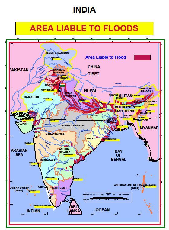
 India is highly vulnerable to floods. Out of the total geographical area of 329 million hectares (mha), more than 40 mha is flood prone. Floods are a recurrent phenomenon, which cause huge loss of lives and damage to livelihood systems, property, infrastructure and public utilities. It is a cause for concern that flood related damages show an increasing trend. The average annual flood damage in the last 10 years period from 1996 to 2005 was Rs. 4745 crore as compared to Rs. 1805 crore, the corresponding average for the previous 53 years. This can be attributed to many reasons including a steep increase in population, rapid urbanization growing developmental and economic activities in flood plains coupled with global warming.

An average every year, 75 lakh hectares of land is affected, 1600 lives are lost and the damage caused to crops, houses and public utilities is Rs.1805 crores due to floods. The maximum number of lives (11,316) was lost in the year 1977. The frequency of major floods is more than once in five years.

Floods have also occurred in areas, which were earlier not considered flood prone. An effort has been made in these Guidelines to cover the entire gamut of Flood Management. Eighty per cent of the precipitation takes place in the monsoon months from June to September. The rivers a bring heavy sediment load from catchments. These, coupled with inadequate carrying capacity of rivers are responsible for causing floods, drainage congestion and erosion of river-banks. Cyclones, cyclonic circulations and cloud bursts cause flash floods and lead to huge losses. It is a fact that some of the rivers causing damage in India originate in neighboring countries; adding another complex dimension to the problem. Continuing and large-scale loss of lives and damage to public and private property due to floods indicate that we are still to develop an effective response to floods. NDMA’s Executive Summary Guidelines have been prepared to enable the various implementing and stakeholder agencies to effectively address the critical areas for minimising flood damage.

Floods


Emergency Kit

  • Battery operated torch
  • Extra batteries
  • Battery operated radio
  • First aid kit and essential medicines
  • Emergency food (dry items) and water (packed and sealed)
  • Candles and matches in a waterproof container
  • Knife
  • Chlorine tablets or powdered water 
  • Important documents (Ration card, Voter ID card, Aadhar Card etc.)
  • Cash, Aadhar Card and Ration Card
  • Thick ropes and cords
  • Shoes